First of all, kudos to the National Hurricane Center for generating this map so quickly ahead of a storm that hasn’t really developed yet.
A potentially dangerous storm is forming in the northwestern Caribbean and could rapidly strengthen into a major hurricane as it moves into the Gulf of Mexico later this week. By Thursday, the storm could bring life-threatening storm surge, heavy rains, and damaging winds to parts of the Gulf Coast. To monitor this rapidly evolving situation, a Hurricane Hunter aircraft has been deployed to gather critical data from inside the storm.
Here is everything you need to know: timing, potential impacts, and why Hurricane Hunters are essential for storm forecasting.
What is Happening Right Now?
A large area of low pressure produces disorganized showers and thunderstorms over the northwestern Caribbean Sea. Although the system is poorly organized, it is expected to strengthen into a tropical storm in 24 hours. As it moves north through the Gulf of Mexico, it could develop into a major hurricane (Category 3 or higher), threatening areas from the Florida Panhandle to any of the Florida peninsula among other states.
Hurricane Hunters Are on The Job!
As this system develops, real-time data is critical to understanding how strong it could become and where it is headed. That is where the Hurricane Hunter aircraft comes in. These highly specialized planes, flown by the Air Force Reserve, are sent into the heart of developing storms to measure key factors like wind speed, air pressure, and storm structure.
Why is this important? The storm is still disorganized, and computer models can only predict based on limited satellite data. By flying into the storm, the Hurricane Hunters provide real-time measurements, which help meteorologists create more accurate forecasts.
The Hurricane Hunter aircraft is scheduled to investigate the storm this afternoon (Monday, September 23, 2024). This data will be crucial for the National Hurricane Center (NHC) as it updates its forecasts.
With the storm likely to strengthen quickly, the data collected could confirm the rapid development into a hurricane and offer better insight into its exact path.
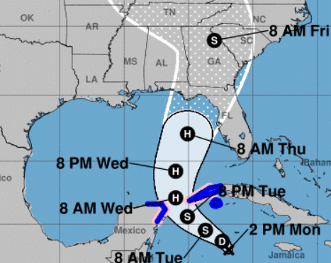
In general terms, here is how to interpret the map.
The Cone of Uncertainty: The white-shaded area on the map shows the possible paths of the storm’s center. Remember that even outside the cone, the impacts (intense winds, rain, and storm surge) could still affect your area, especially on the east side of the storm.
Time Points: Labels like “8 AM Thursday” show when and where the storm is expected to be at that time. For example, the storm may be near the Florida Panhandle or Western Florida by Thursday morning as a major hurricane.
Intensity Symbols (H, S, D): H means Hurricane, S means Tropical Storm, and D on the map represents a Tropical Depression. It is forecast to be a hurricane over the Gulf of Mexico by Wednesday, and it could become a Category 3 or higher hurricane by Thursday.
Warnings and Watches: Tropical Storm Warnings and Hurricane Watches have been issued for parts of western Cuba and the northeastern Yucatan Peninsula. People in these areas should expect tropical storm conditions with the possibility of hurricane-force winds soon.
Storm Timeline and Locations at Risk
Today through Tuesday: The storm is moving through the northwestern Caribbean, producing heavy rain and gusty winds. On Tuesday night, it could be near hurricane strength as it approaches the Yucatan Channel.
Wednesday and Thursday: As the system moves through the Gulf of Mexico, it is expected to strengthen significantly. By Thursday, the storm could land as a major hurricane, bringing dangerous conditions to the northeastern Gulf Coast—including the Florida Panhandle and western Florida.
What You Should Do Now
Residents along the Gulf Coast, especially in the Florida Panhandle and the western Florida coast, should monitor this storm closely. Here are some steps to take now:
Stay Informed: Follow updates from the National Hurricane Center. Hurricane Hunter data will soon provide more details on the storm’s strength and path, so stay tuned for new information.
Prepare for Hurricane Conditions:
– Ensure you have a hurricane preparedness kit containing food, water, medications, flashlights, and batteries.
– Know your evacuation routes in case of a storm surge or significant flooding.
– Secure outdoor items like patio furniture and bring in any loose objects that intense winds could throw.
Please Do not Wait Until the Last Minute: As the storm strengthens, its impacts could be far-reaching. Even if you are outside the direct path, the storm’s effects can extend hundreds of miles from the center, especially on the eastern side. Be prepared for heavy rain, flooding, and damaging winds.
This is a rapidly evolving storm system, and with the help of Hurricane Hunter aircraft, the National Hurricane Center is closely monitoring its development. The potential for rapid strengthening into a major hurricane means that residents in the Gulf Coast should take this storm seriously and prepare accordingly.