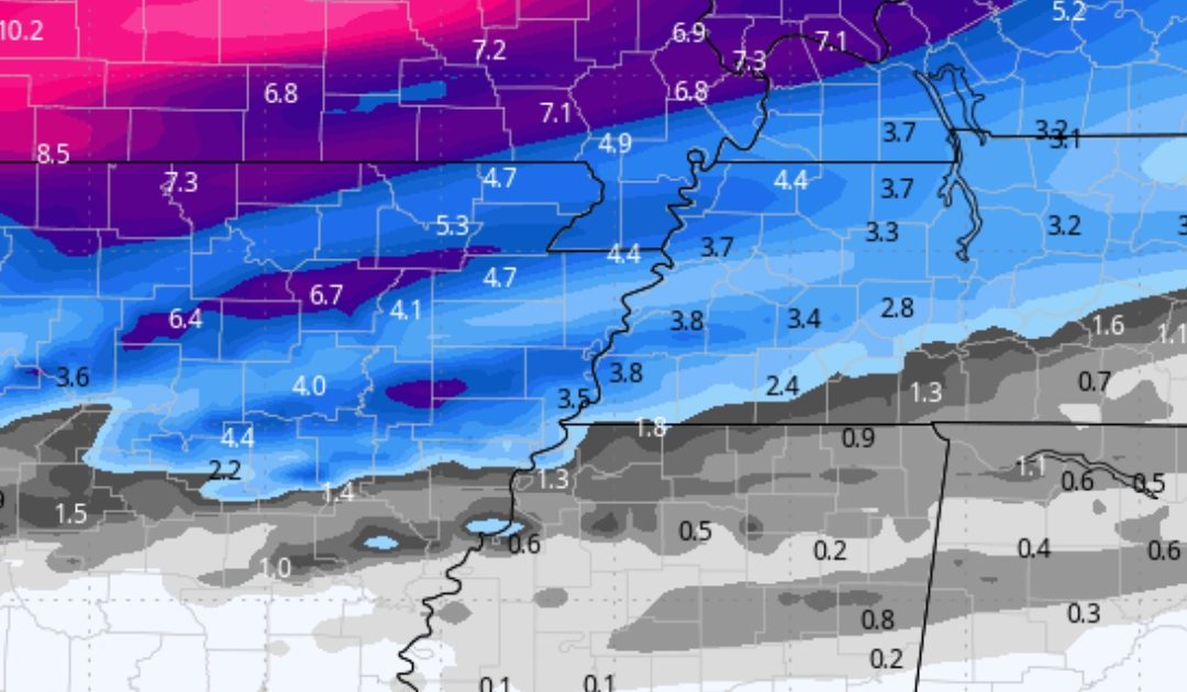
The image I am using here is the European model. It tends to do better in significant winter events. So, what is the latest on this storm? I want to stress that there are still several question marks with this system and new developments will likely be later this afternoon.
Fresh Computers Models are Out, and Here is What You Need to Know in a Simplified Way to Understand
A powerful winter storm is set to impact Arkansas, Tennessee, Missouri, Kentucky, Indiana, and northern Mississippi beginning Tuesday and lasting through Wednesday. The National Weather Service has issued Winter Storm Warnings and Watches, signaling the potential for heavy snow, icy roads, and dangerously cold temperatures over the next few days.
If you ever need an expert meteorologist witness for weather-related litigation you can click here
What’s Happening?
This storm is driven by a strong Arctic cold front sweeping through the region, bringing significant snowfall and bitterly cold air. Some areas could see 3 to 5 inches of snow, with parts of Missouri and Arkansas receiving even higher totals. Wind chills could drop below zero later this week.
Who Will Be Affected?
- Northern Arkansas, West Tennessee, and Southeast Missouri, in addition to North Mississippi, although with lighter amounts and considerably more uncertainty– 3 to 5 inches of snow expected, leading to dangerous travel conditions.
- Areas south of I-40 – Uncertain mix of snow, sleet, and freezing rain, which could lead to icy roads and difficult driving.
- Southern Missouri & Northern Arkansas – 4 to 7 inches of snow possible, with strong winds causing drifting and visibility issues.
- Northern Mississippi – Less snow accumulation expected, but still hazardous amounts of ice and lighter snow, making roads slick and travel dangerous.
Timeline – When to Expect the Worst
- Tuesday Morning – Snow develops in Missouri and northern Arkansas, spreading southward.
- Tuesday Afternoon – Snow intensifies across Tennessee, Kentucky, and eastern Arkansas. Travel becomes hazardous.
- Tuesday Night – The heaviest snowfall occurs. Expect low visibility, slick roads, and strong winds.
- Wednesday Morning – Snow tapers off, but subfreezing temperatures will keep roads dangerous.
- Thursday Morning – Extreme cold moves in, with wind chills dropping below zero in some areas.
What This Means for You
- Travel Will Be Dangerous – Roads, especially bridges, will be icy and slick.
- Blowing & Drifting Snow – Wind gusts up to 30 mph could cause whiteout conditions.
- Record-Breaking Cold to Follow – Wind chills below zero will make outdoor conditions extremely dangerous.
How to Stay Safe
- Stay Off Roads If Possible – If travel is necessary, carry an emergency kit with blankets, food, and a flashlight.
- Prepare Your Home – Charge devices, check heating systems, and stock up on supplies.
- Dress in Layers – With dangerous wind chills expected, exposure to the cold for even a few minutes can be hazardous.
- Check on Family & Neighbors – Ensure that elderly individuals, children, and pets have a warm place to stay.
Final Thoughts From Me at This Point
This winter storm will significantly disrupt travel, school schedules, and daily routines. Now is the time to prepare before conditions deteriorate. Over the next few days, expect snow, ice, and extreme cold.
Stay updated, stay safe, and let us know how you’re preparing for this storm in the comments.