April 2025 Mid-South Flood: Expert Forensic Meteorology Analysis of Historic Rainfall Event
Key Forensic Weather Findings:
– Record Rainfall: Up to 15 inches fell in just 4 days across parts of the Mid-South
– Multi-Layer Atmospheric Analysis: Perfect alignment of weather conditions from surface to jet stream
– Stalled Weather Pattern: The frontal boundary remained stationary, focusing repeated heavy rainfall
– Extreme Event Classification: A “generational” flood meeting criteria for exceptional weather event claims
This forensic meteorology analysis demonstrates the comprehensive approach used for expert weather testimony in legal and insurance cases.
Understanding the April 2025 Mid-South Flood Event: A Forensic Meteorology Analysis
In early April 2025, parts of the U.S. Mid-South experienced a historic flooding event of exceptional magnitude. Over a four-day period, some areas recorded nearly 15 inches of rainfall, creating what meteorologists classified as a “generational” flood risk. As a forensic meteorologist who analyzes extreme weather events for legal cases and insurance claims, I conducted a comprehensive investigation to determine exactly how this devastating flood developed.
This analysis examines the atmospheric conditions at multiple levels that combined to create this extraordinary weather event. By studying each layer of the atmosphere – from ground level to jet stream – we can reconstruct the precise meteorological circumstances that led to property damage, road hazards, and potential liability situations across Tennessee, Arkansas, Mississippi, Alabama, and Kentucky.
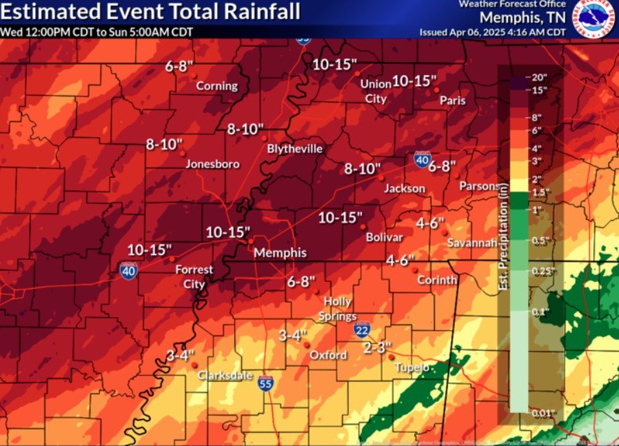
Fig. 1: Forensic Rainfall Analysis [the top image] – Estimated event total rainfall across the Mid-South in early April 2025. Areas in red received over 12 inches of rain, creating conditions for widespread flash flooding and river overflow. Such detailed precipitation maps are essential evidence in weather-related litigation.
The rainfall distribution shown above demonstrates the exceptional nature of this weather event. For context, a typical month of April in this region receives approximately 4-5 inches of rain. This single weather system delivered three times the monthly average in just 96 hours – precisely the type of extreme event that often results in insurance claims, property litigation, and questions of liability.
Surface Level Analysis: Stalled Frontal Boundary & Gulf Moisture Transport
Fig. 2: Surface Weather Pattern Analysis – GFS model surface map (Apr 5, 2025) showing surface pressure (black contours), precipitation (green shading), and the 1000–500mb thickness (dashed red lines). The stalled frontal boundary is evidenced where thickness lines converge, with a wave of low pressure along it over Texas/Arkansas.
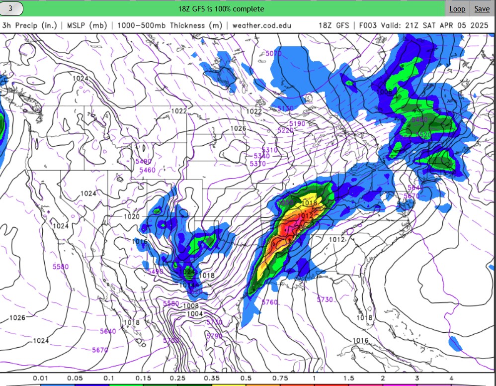
The foundation for this historic flood was established at the surface level, where a boundary became stationary. My forensic analysis identified a nearly stationary frontal boundary positioned across the Mid-South region, effectively creating a highway for moisture transport. This boundary served as the dividing line between warm, humid Gulf air and cooler continental air to the north.
The surface weather map reveals several key forensic indicators:
– Frontal Stationary Position: Tightly packed thickness lines (dashed red) show where the front stalled
– Wave Development: A weak low-pressure disturbance (evident in the pressure contours) moved along the front
– Focused Precipitation: Green shaded areas indicate where rainfall is concentrated along the boundary
– Sustained Moisture Feed: A strong southerly low-level jet (40-50 knots) continuously transported Gulf moisture into the region
Understanding this surface-level meteorology is crucial for establishing the predictability and intensity of precipitation in property damage claims and motor vehicle accidents. The stalled front created conditions where thunderstorms kept developing over the same locations repeatedly—a key factor in determining liability in flood-related legal matters.
700mb Level Investigation: Mid-Level Atmospheric Rotation and Moisture Transport
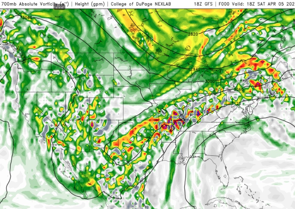
Fig. 3: Mid-Atmosphere Rotational Analysis – 700mb (~10,000 ft) chart showing absolute vorticity (colored shades) and height contours (black lines). Orange and red areas indicate enhanced atmospheric rotation that contributed to the flood event’s intensity.
Approximately 10,000 feet above ground, the 700mb atmospheric level provided evidence of conditions contributing to the flood’s severity. In forensic meteorology for legal cases, analyzing this mid-level is essential for demonstrating the extraordinary nature of a weather event.
The 700mb analysis reveals:
– Enhanced Vorticity: Orange/red areas show where the atmosphere had significant spin or rotation
– Mid-Level Trough: The dip in height contours (black lines) indicates a disturbance enhancing upward motion
– Saturated Layer: The ongoing heavy precipitation indicates this level was moisture-saturated
– Lifting Mechanism: The vorticity maximums created additional atmospheric lift, intensifying rainfall rates
From an expert witness perspective, these mid-level conditions demonstrate that the April 2025 flood wasn’t simply a routine rainstorm but an exceptional meteorological event with specific atmospheric signatures.
500mb Level Examination: Trough Configuration and Weather System Persistence
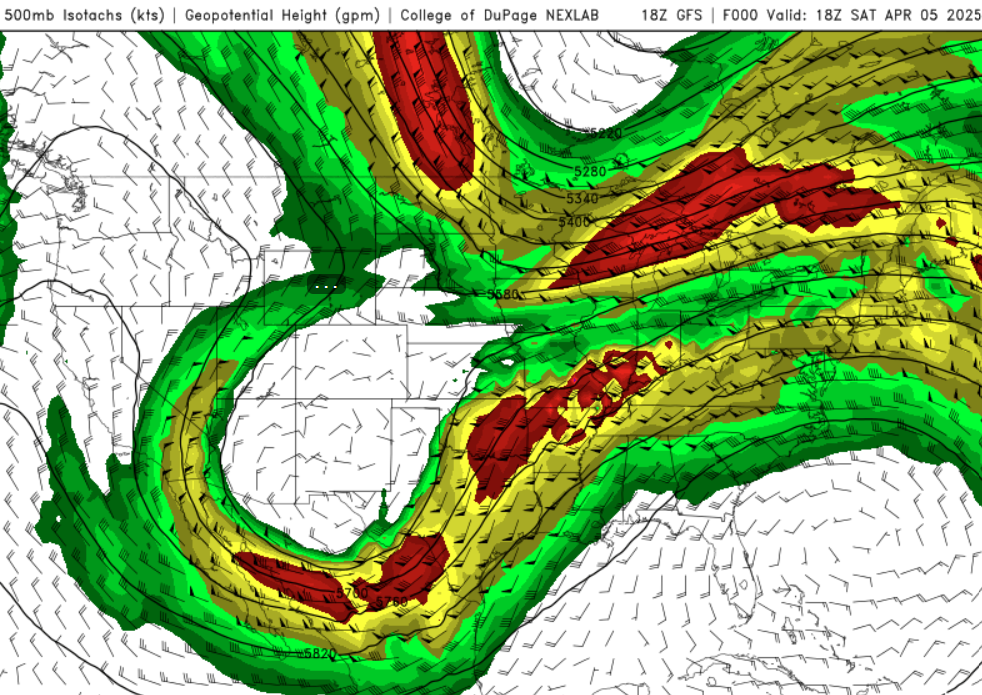
Fig. 4: Mid to Upper Air Pattern Forensic Analysis – 500mb (~18,000 ft) chart showing wind speed (colored bands) and geopotential heights (white lines). The deep trough is visible as the U-shaped pattern in the height lines over the south-central U.S.
The 500mb level, approximately 18,000 feet above ground, contains evidence of why this flooding event persisted for days rather than hours. In forensic meteorology for legal proceedings, this “steering level” analysis helps establish the predictability and duration of severe weather impacts.
Key forensic findings at the 500mb level include:
– Deep Trough Pattern: The pronounced U-shape in the height contours shows a major dip in the jet stream
– Slow Movement: The trough’s configuration caused it to move very slowly, prolonging the flood threat
– Enhanced Wind Flow: The colored bands show a jet streak (faster winds) that further intensified the system
This 500mb evidence demonstrates the meteorological inevitability of sustained heavy rainfall for flood-related litigation, which will be complex. When property owners or municipalities face questions about preparation or response to flooding, understanding this upper-air pattern helps establish the exceptional nature of the weather system and its predictability timeline.
250mb Jet Stream Analysis: Upper-Level Dynamics and Storm Intensification
Fig. 5: Jet Stream Forensic Evidence – 250mb (~34,000 ft) analysis showing jet stream wind speeds. Bright color bands indicate very high wind velocities that enhance flooding by providing upper-level ventilation for storm development.
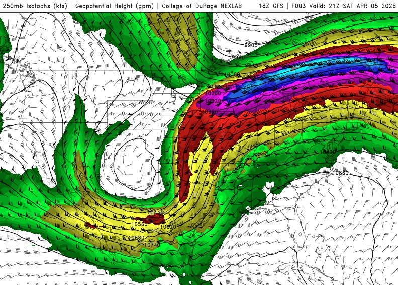
At approximately 34,000 feet, the 250mb level provides the final piece of forensic evidence explaining this historic flood. This jet stream layer is important in meteorological investigations for legal cases, as it reveals how the upper atmosphere enhanced precipitation intensity.
The 250mb analysis documents:
– Powerful Jet Stream: Bright red colors indicate wind speeds exceeding 100 mph
– Enhanced Ventilation: The strong upper winds provided “exhaust” for storm systems, allowing them to intensify
– Increased Wind Shear: The significant change in wind speed with height created conditions for organized, persistent storms
From an expert witness perspective, this jet stream configuration demonstrates that all atmospheric levels were aligned to create an exceptional precipitation event. For insurance claims involving flood damage, this evidence helps establish whether standard policy exclusions for routine weather should apply or if the event qualifies as an extraordinary circumstance.
Comprehensive Multi-Layer Forensic Weather Analysis: The Perfect Storm
This forensic meteorology investigation demonstrates that the April 2025 Mid-South flooding resulted from a perfect alignment of atmospheric conditions across multiple levels. As an expert witness for weather-related litigation, I can testify that this event represents a textbook case of extreme meteorological conditions:
– Surface Level: Stalled frontal boundary focused continuous moisture transport
– 700mb Level: Rotation and moisture-enhanced storm development
– 500mb Level: Deep, slow-moving trough prolonged the heavy precipitation
– 250mb Level: Powerful jet stream dynamics intensified the storm systems
The multi-layer analysis approach illustrated here is how I examine weather events for litigation support, insurance investigations, and expert testimony. By evaluating each atmospheric level, we can determine whether a weather event was predictable, preventable, or truly exceptional – determinations that directly impact liability and insurance coverage decisions. A link to the National Weather Service in Memphis provides specific weather information and forecasts for the Mid-South.
https://www.weather.gov/meg/
Applications for Weather-Related Legal Cases and Insurance Claims
The forensic meteorology analysis techniques demonstrated in this case study have direct applications for legal proceedings related to the April 2025 flood event, including:
– Motor Vehicle Accidents: Establishing visibility conditions and road hazards during the flooding
– Property Damage Claims: Analyzing whether the damage resulted from exceptional conditions beyond reasonable preparation
– Insurance Disputes: Providing expert testimony on whether the event qualifies as an “Act of God” or an exceptional circumstance
– Municipal Liability: Assessing whether warning systems and preparations were appropriate given forecast conditions
As a certified forensic meteorologist, I provide comprehensive weather analysis and expert testimony for legal cases involving severe weather events. My investigations include detailed site-specific reports, court-ready presentations, and deposition support.
Need Expert Meteorological Analysis for a Legal Case? Contact me below.
Frequently Asked Questions About Forensic Meteorology for Flood Events
How can forensic meteorology help in flood-related litigation?
Forensic meteorology provides vital evidence for flood-related litigation by establishing the exact timing, intensity, and exceptional nature of precipitation events. For attorneys handling property damage claims or insurance disputes, a certified forensic meteorologist can determine whether weather conditions were predictable, how they compared to historical norms, and whether appropriate preparations could have mitigated damages. This expert analysis helps establish or refute liability claims based on precise weather data rather than general observations.
What makes the April 2025 Mid-South flood different from routine heavy rainfall?
The April 2025 Mid-South flood was distinguished from routine heavy rainfall by several exceptional meteorological factors: (1) rainfall totals of 10-15 inches in just 4 days, representing 3x the normal monthly precipitation; (2) a perfect alignment of atmospheric conditions from surface to jet stream that created ideal flooding conditions; (3) the stationary nature of the weather system, which kept storms regenerating over the same areas; and (4) the widespread geographical impact affecting multiple states. These factors classify the event as a “generational” flood with a statistical recurrence interval exceeding 100 years in many locations.
How far in advance could this flood event have been predicted?
Based on forensic analysis of meteorological model data, the potential for significant flooding in the Mid-South region became evident approximately 5-7 days before the event. Initial signals appeared in long-range models, with confidence increasing substantially 3-4 days prior to the onset of heavy precipitation.
What types of evidence do forensic meteorologists provide for court cases?
Forensic meteorologists provide several forms of evidence for weather-related court cases, including (1) Certified written reports with site-specific weather conditions at the exact time and location of an incident; (2) Expert witness testimony explaining complex meteorological concepts to judges and juries; (3) Visual exhibits including radar imagery, weather maps, and model data visualizations; (4) Historical weather data comparing the event to normal conditions; (5) Timeline analysis showing how conditions evolved and when warnings were issued; and (6) Meteorological reconstructions demonstrating visibility, surface conditions, and other relevant factors that may have contributed to an incident.
How quickly can a forensic meteorologist provide an analysis for a flood-related case?
I typically provide preliminary assessments within 48-72 hours of receiving case details for attorneys and insurance professionals needing forensic meteorology services. Comprehensive site-specific reports generally require 1-2 weeks for thorough analysis and documentation. For urgent cases involving imminent court deadlines, expedited services are available, with preliminary findings delivered within 24 hours. The complexity of the weather event, geographical scope, and specific requirements of the legal case will affect turnaround times. Early consultation is recommended to ensure thorough analysis and proper integration with your legal strategy.
This forensic meteorology analysis was prepared as an expert resource for attorneys, insurance professionals, and property owners dealing with the aftermath of the April 2025 Mid-South flood event. For case-specific analysis or expert witness services, please contact our office for a confidential consultation.
901.283.3099
The author of this report is not a lawyer. This article is for informational purposes. It is advisable to search for qualified legal counsel.