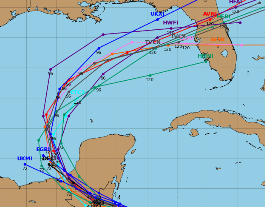
Spaghetti Plots Unveiled: The Secret to Tracking Tropical Storm Sara’s Next Move
When monitoring tropical storms like Tropical Storm Sara, one term you may encounter often is “spaghetti plots.” These colorful, sometimes chaotic-looking maps are a crucial tool for forecasters and a window into the possible future paths of tropical cyclones. Let’s dive into what they are, why they matter, and how they tie into Sara’s current situation.
What Are Spaghetti Plots?
Spaghetti plots represent multiple weather models’ predictions of a storm’s track. Each line—resembling strands of spaghetti—represents a single forecast model’s prediction. When bundled on a map, they show a range of possible paths a storm might take, helping meteorologists and emergency managers assess the most likely outcomes.
Here’s why they’re essential:
- They Show Model Agreement (or Disagreement): When the lines cluster tightly together, it indicates high confidence in the storm’s path. If they spread widely, uncertainty increases, signaling the need for broader preparation.
- They Highlight Influencing Factors: Spaghetti plots reveal the competing atmospheric forces that steer storms, like ridges, troughs, or wind shear.
- They Help Narrow Risks: By overlaying these paths, forecasters can prioritize areas most likely to face impacts, from rainfall to wind and storm surge.
How Do They Relate to Tropical Storm Sara?
In the latest update, Sara’s track is a textbook case of why spaghetti plots are invaluable. The National Hurricane Center (NHC) forecasts Sara to move westward, slowing as it approaches the Gulf of Honduras. However, as the mid-level ridge shifts northeast tomorrow, Sara’s motion will likely pick up speed, veering slightly to the west-northwest.
Spaghetti plots for Sara likely reveal:
- Tight clustering in the short term: Confidence is high that Sara will remain just offshore before impacting Belize.
- Broader spread beyond landfall: Once Sara interacts with land and weakens, model paths diverge as the system is expected to open into a trough in the Gulf of Mexico.
These plots help forecasters determine scenarios like:
- Will Sara intensify further offshore? (Key for predicting wind and surge impacts.)
- How far inland will heavy rain and flash flooding extend?
- Could remnants bring rain to other parts of the Gulf?
What Does This Mean for You?
Spaghetti plots are not just tools for meteorologists—they’re practical guides for everyone curious about Sara’s path. Understanding where models agree or differ, you can better prepare for potential outcomes, from flash flooding to tropical storm-force winds.
For Sara, here are the key takeaways:
- Flooding Is the Immediate Concern: Heavy rainfall will continue to cause life-threatening flash flooding and mudslides in northern Honduras and beyond.
- Track Adjustments Are Possible: While the forecast keeps Sara offshore before Belize landfall, small shifts in the center’s position could influence how strong it gets or where the heaviest impacts occur.
- Post-Landfall Impacts: Even as Sara weakens, her remnants will carry moisture into the Gulf of Mexico, potentially merging with a new system and influencing weather farther afield.
Sara and the Power of Forecast Tools
Tropical Storm Sara reminds us of the dynamic nature of weather and the importance of tools like spaghetti plots. These plots give us a glimpse into what’s possible, empowering communities to act cautiously and confidently.
Stay tuned to updates from trusted sources like the National Hurricane Center and keep an eye on those spaghetti strands—they might look like a tangled mess, but they’re helping untangle Sara’s story. Check out the National Hurricane’s website for additional information.