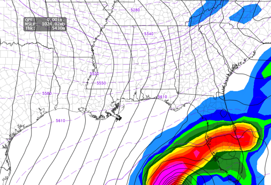
For context, the bottom right part of the image shows the storm with all the bright colors and that area is South Florida. Model runs today need to be carefully watched as I expect changes in the track.
The current weather disturbance deep in the Caribbean is something to watch I believe and potentially be concerned about.
The National Hurricane Center (NHC) is closely monitoring a broad area of low pressure, designated as AL99, situated over the central Caribbean Sea. This system is producing extensive showers and thunderstorms, with environmental conditions highly favorable for development. The NHC reports a 90% chance of tropical depression formation within the next 48 hours as the system moves slowly westward into the western Caribbean Sea. Further development is anticipated as it meanders over the western Caribbean through the weekend, with a projected northwestward turn by early next week. Residents across the western and northwestern Caribbean Sea are advised to monitor this system closely. Regardless of development, heavy rains are expected over Jamaica in the coming days.
Environmental Conditions Favoring Development
The Caribbean Sea and Gulf of Mexico currently exhibit sea surface temperatures conducive to tropical cyclone development. Additionally, atmospheric conditions, including low wind shear and ample moisture, support the potential strengthening of the system. These factors collectively create an environment that could facilitate the intensification of AL99 into a significant tropical cyclone.
Potential Impacts
While it’s premature to determine the exact path of AL99, current model guidance suggests a potential westward shift compared to earlier projections. The system’s trajectory will likely be influenced by an approaching cold front over the Eastern United States. If this cold air advances earlier than expected, it could steer the storm eastward and northeastward more quickly, increasing the risk to Florida. Conversely, a slower-moving front may allow the system to track further west, potentially impacting the Gulf Coast.
Potential hazards associated with this system include:
Heavy Rainfall: This leads to flash flooding in affected areas.
Strong Winds: Capable of causing structural damage and downing trees.
Storm Surge: Elevated sea levels pose risks to coastal communities.
Power Outages: Resulting from wind damage to infrastructure.
Historical Context: Hurricane Kate
Hurricane Kate occurred in November 1985. It reached its peak strength as a Category 3 hurricane with winds exceeding 115 mph while in the Gulf of Mexico. On November 21, 1985, Kate made landfall on the Florida Panhandle near Mexico Beach as a Category 2 hurricane with maximum sustained winds of 100 mph
Advancements in Forecasting: AI Integration
Recent advancements in meteorological forecasting have seen the integration of artificial intelligence (AI) models, enhancing the accuracy of hurricane predictions. The European Centre for Medium-Range Weather Forecasts (ECMWF) has developed an experimental AI-based forecasting system known as AIFS. This system utilizes machine learning techniques to analyze vast datasets, providing frequent model runs. During the current hurricane season, AIFS has demonstrated commendable performance, accurately predicting the paths of several tropical systems.
Here is a link to an article about this new model. Capturing uncertainty in forecasts based on AI | ECMWF
Commitment to Updates
Given the dynamic nature of tropical systems especially this late in the season, it’s critical to remain informed through reliable sources. I am committed to providing regular updates as new information becomes available, ensuring you have the latest data to make informed decisions.
Preparedness Recommendations
For residents in the potential impact zones, it’s advisable to:
Stay Informed: Regularly check updates from the NHC and local weather services.
Prepare Emergency Kits: Include essential supplies such as water, non-perishable food, medications, and important documents.
Review Evacuation Plans: Know your evacuation routes and have a plan in place.
Secure Property: Ensure that your home is fortified against potential wind damage.
By taking these steps, you can enhance your preparedness and safety in the event of a tropical cyclone impact.
A great resource to check out is the National Hurricane Center and you can find the link here. National Hurricane Center