The Snow is Expected to Begin as Early as Thursday Afternoon and Evening and Persist into Friday Night.
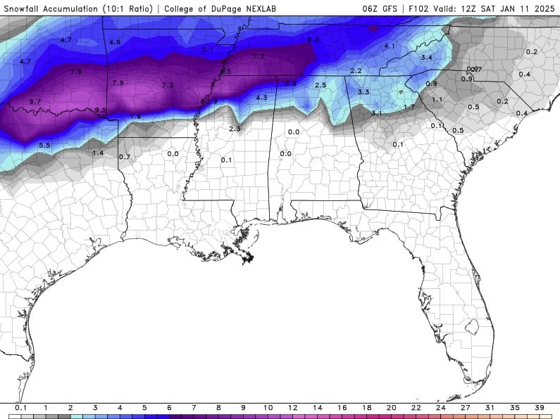
Snowfall Forecast
Shelby County, Tennessee (Memphis)
Current Forecast
- Snowfall Range: 4 to 7 inches
- Alert Level: Purple Zone (Heavy Snowfall)
- Primary Concerns: Hazardous travel, potential power outages, disruptions to daily activities
What Do the Colors on the Map Mean?
- Purple Areas
-
- Heaviest snowfall (6 to 10 inches or more)
- Major impacts expected
- Dangerous road conditions
- High risk of power outages
- Medium Blue Areas
-
- Moderate snowfall (3 to 6 inches)
- Slick roads
- Likely travel delays
- Light Blue Areas
-
- Light snowfall (1 to 3 inches)
- Minor disruptions
- Slippery conditions possible
- Gray Areas
-
- Very light snow or flurries (less than 1 inch)
- Minimal impacts expected
Regional Overview
Arkansas
Purple Zone (Heaviest Snowfall)
- Little Rock: 7 to 9 inches
- Jonesboro: 7 to 9 inches
- Conway: 8 to 9 inches
Tennessee
Purple Zone (Heaviest Snowfall)
- Shelby County (Memphis): 4 to 7 inches
- Jackson: 7 to 8 inches
- Dyersburg: 7 to 8 inches
- Clarksville: 6 to 7 inches
Mississippi
Purple Zone (Heaviest Snowfall)
- Hernando: 6 to 7 inches
- Southaven: 6 to 7 inches
Key Takeaways
Shelby County (Memphis)
Expect 4 to 7 inches of snow. This is enough to cause major disruptions and hazardous conditions.
Heaviest Snowfall Areas
Central Arkansas, northern Mississippi, and western/northern Tennessee, with totals up to 10 inches or more.
Impacts
- Travel: Roads will be dangerous or impassable in purple areas.
- Power: Power outages are possible in areas receiving heavy snow.
- Schools/Work: Expect closures or delays in the hardest-hit regions.