A fascinating weather pattern is developing across the United States on Monday, creating a stark contrast between drenched and dry regions. The weather map tells quite a story, with a distinct dividing line running through the heart of the country. As a 27-year weather expert, I’ve seen crazier, but this pattern is certainly not boring.
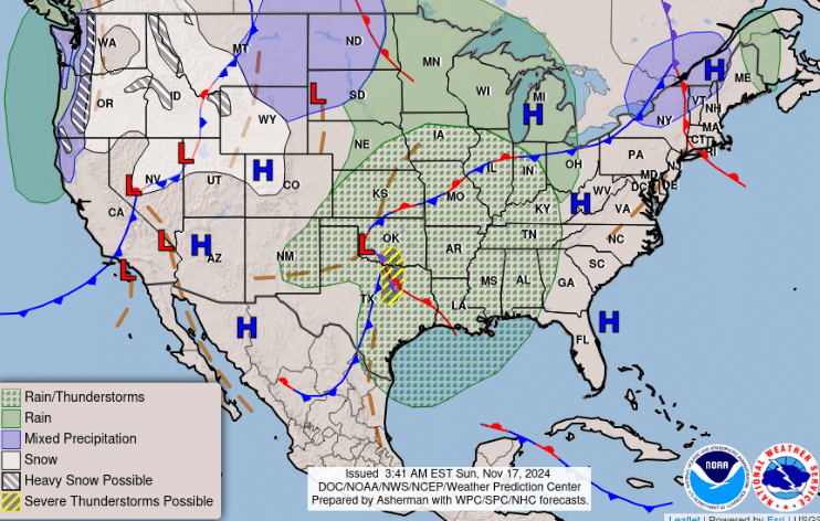
The Central Plains and parts of the Southeast are experiencing significant rain and thunderstorm activity. This wet weather system stretches from Nebraska down through Texas and across to parts of the Gulf Coast states. If you’re in these regions, you’ll want to keep an umbrella handy!
Meanwhile, the Western states and Northeast are experiencing markedly different conditions. High-pressure systems keep things dry and stable in several areas, particularly in the Southwest and along the East Coast.
What’s particularly interesting is how sharply defined these weather boundaries are. It’s almost as if Mother Nature drew a line down the middle of the country, creating two distinct weather zones.
For those traveling this week:
- Central Plains: Pack rain gear and be prepared for potential thunderstorms
- Southeast: Expect wet conditions and possible severe weather
- West and Northeast: Generally dry and stable conditions
- Watch for mixed precipitation in northern regions
Keep in mind that weather patterns can shift quickly, so stay tuned to your local weather updates for the most current information. This unusual split pattern reminds us just how diverse and dynamic American weather can be! If you are flying into or through these regions, allow extra time to get to the airport. For those driving in the troubled areas, slow it down. Safety first.
To keep up with weather maps daily you can bookmark this site.
If you need expert weather advice don’t hesitate to reach out to John Bryant.