Tropical cyclones have a life cycle, much like a living organism—a beginning, a ferocious peak, and eventually, a slow and beautiful unraveling. Tropical Storm Sara has been on an interesting journey through the dissipating stages of a once-healthy tropical system. The use of satellite imagery tells a story of transition, of change, and ultimately of the forces that return these atmospheric giants to calm.
This particular tropical system, Tropical Storm ‘SARA’—began in the depths of the Atlantic, where warm waters bred a system eager to grow. For days, SARA marched westward, its cloud bands swirling in a textbook spiral. Satellite imagery painted a nice view: bright white convective towers pierced the atmosphere, and symmetrical outflow gave SARA the appearance of a beautifully painted tropical system ready to explode.
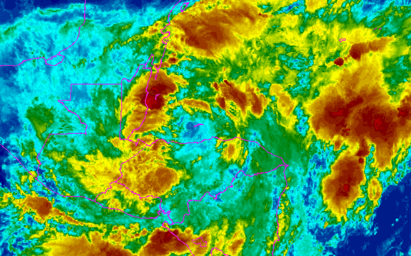
But like all tropical systems, SARA had a finite amount of energy. The signs of its decay began slowly, almost imperceptibly at first. It started with subtle changes—a slight tilting of its core, visible on infrared imagery as warm colors crept closer to the center, indicating the loss of a strong updraft. The once eye-popping convection was less organized, and bright whites on the visible images faded to duller grays and blues on the infrared images. The story that the satellite imagery told was one of exhaustion. Interaction with land will begin taking its toll, disrupting the symmetry of SARA’s circulation.
Water vapor imagery gave me a forensic clue into SARA’s struggles. Dry air, often seen in a sickly yellow or tan hue, began to wrap into the western half of the storm, choking off the moisture SARA needed to sustain its thunderstorms. The once vibrant colors painted on our screens, emblematic of powerful deep convection, began to dull. The storm looked ragged, like an exhausted marathon runner nearing the finish line.
SARA’s core began to collapse. No more did satellite imagery depict a powerful rotating cyclone. Instead, all that is left is a disheveled swirl of lower-level clouds, drifting without purpose. Visible imagery, as the morning sun rose, showed that SARA was now just a shell of its former self. It resembled a torn-up piece of cotton candy, with fractured cloud bands and no distinct center—a once mighty looking storm ready to rapidly intensify over the warm waters of the Gulf and points South.
Forensic meteorologists take an interest in these dissipation phases because they teach us about the delicate balance that sustains tropical cyclones. Satellite imagery allows us to dissect this end-of-life process in rich detail—the slow erosion of convection, the dry air encroachment, and the structural unraveling that spells the end for these systems.
And so, SARA is taking her final breath, not with a dramatic Category 5 landfall but still with a destructive punch South of the United States, and with a dissolution that the satellites captured, frame by frame. It’s a humbling reminder that even in an environment that feeds these titanic forces, nature’s counterbalances always have the final say.
For those watching from above, the demise of a tropical system like SARA is more than just a scientific observation; it’s a poignant chapter in the ever-turning narrative of the atmosphere. It’s the earth breathing, it’s the ocean talking, and, ultimately, it’s the atmosphere finding balance once again.
Satellite imagery helps us understand these giants from birth to death and helps us better prepare, predict, and respect the incredible power of our vast atmosphere.