
A Potential Very Strong Storm Threatens the Gulf Coast and Eastern U.S. – Track Shifts East in Latest Models
A potentially dangerous hurricane could approach the Gulf Coast, and the latest updates from two weather models—the European and GFS—show significant shifts in the storm’s track. Both models now suggest that the storm will land further east than previous runs, potentially impacting the Florida Panhandle on Thursday afternoon. This shift has serious implications for residents along the Gulf Coast, inland areas, and the East Coast, which could also face significant weather-related challenges.
If you are anywhere along the Gulf Coast, from Louisiana to Florida, or in inland areas stretching from Georgia to the Carolinas, you must pay close attention to this evolving situation. Here is what the latest weather models tell us and what you should do to prepare.
The models have shifted on their tracks, which is expected this many days out.
Meteorologists use dozens of models to predict hurricane paths: the European Model and the Global Forecast System (GFS) model are two of those. Both models have shown a noticeable eastward shift in the storm’s track over the past couple of days.
European Model (First Image)
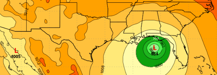
The European model shows a powerful hurricane making landfall near the western Florida Panhandle. The storm’s central pressure is estimated at 978 mb, which indicates a strong hurricane capable of causing significant wind damage and storm surges.
Critical Areas at Risk: Based on this model, the areas along the Alabama-Florida state line and the western Florida Panhandle should be prepared for fierce winds, heavy rainfall, and dangerous storm surges. Coastal communities are especially vulnerable to flooding, so preparing for potential evacuation orders is essential.
GFS Model (Second Image)
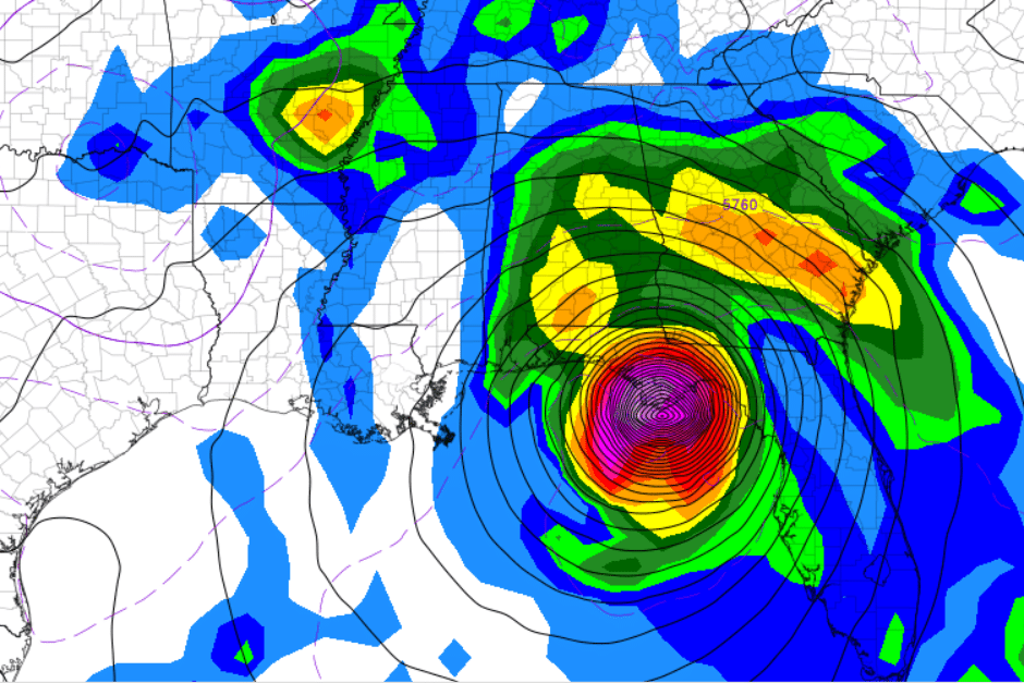
The GFS model also shows a strong storm, but its projected landfall is slightly farther east, still affecting the Florida Panhandle. However, this model emphasizes intense rainfall, expected to extend well beyond the coast. In particular, heavy rains could affect inland areas in Georgia, South Carolina, and even North Carolina.
Critical Areas at Risk: Besides the Florida Panhandle, this model suggests that parts of Georgia and the Carolinas could see widespread flooding, especially in areas prone to flash floods. This storm’s effects could extend far beyond just the coastal regions, making everyone on their path essential to stay informed.
The Track is Still Evolving
While both models show similar paths, it is essential to understand that many factors, including high-pressure systems and other weather patterns, influence hurricane tracks. Because of these constantly changing variables, the track may shift again over the coming days.
What Does This Mean for the East Coast?
Though the storm is expected to land on the Gulf Coast, its impacts could extend far beyond that. As the storm moves inland, the East Coast could face dangerous weather conditions such as flooding rains, high winds, and the potential for tornadoes. This means residents along the Eastern Seaboard should stay alert and closely monitor updates.
What Should You Do Now?
Whether you are located along the Gulf Coast or inland, now is the time to take precautionary steps and prepare for the storm. Here is what you should do based on your location:
Gulf Coast Residents:
Prepare for evacuation orders: If you are in a coastal area, especially along the Florida Panhandle and Alabama, ensure a plan should local authorities issue evacuation notices. Storm surge and flood risks: Coastal communities are at substantial risk of storm surges, which can bring dangerous and rapidly rising floodwaters. Ensure that your home is secure and that you have a supply of sandbags ready if flooding concerns you.
Stock up on supplies: Essentials like water, nonperishable food, medications, and batteries should be on hand in case of power outages or disruptions in services.
Inland and East Coast Residents:
Prepare for potential flooding: Heavy rainfall will likely extend well beyond the coastline, especially in parts of Georgia, South Carolina, and North Carolina. You could still face significant flooding even if you are not in a coastal area.
Monitor travel plans: The storm could cause significant disruptions to travel, including flight delays, road closures, and rail shutdowns. Check for updates and be prepared for changes if you have travel plans.
While there is no need to panic, anyone in this storm’s projected path should take it seriously. The European and GFS models indicate that the storm has shifted east, meaning that previously less likely to be impacted areas could now be at risk. The track could move again so pay attention.
Stay calm, stay informed, and most importantly, take the necessary steps to ensure you and your loved ones are safe as this storm approaches. Whether you are along the Gulf Coast or further inland, the effects of this storm could be far-reaching, and it is better to be prepared early than caught off guard.