Winter Storm Watch: What to Expect & How to Prepare
Before I type this, I want to stress that this is still not a sure bet. The computer models are still slightly conflicted; however, tonight’s Canadian model shows a solid 1-3 inches of snow for Memphis and Shelby County and even into portions of North Mississippi, although slightly less South.
If you ever need an expert witness for weather-related litigation, you can reach out here
A Winter Storm Watch has been issued for portions of Arkansas, Tennessee, Missouri, and Kentucky. The potential for significant snowfall and icy conditions will occur from Tuesday afternoon through early Wednesday morning. If you’re in the Mid-South, here’s what you need to know to stay safe and prepared.
What’s Happening?
A strong weather system will move in from the Great Plains, bringing cold Arctic air into the region. As the system strengthens, it will produce snow, sleet, and freezing rain, especially for areas north of Interstate 40.
How Much Snow Will We Get?
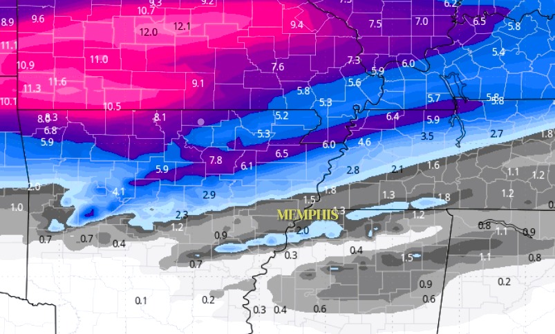
- North of I-40 (Northeast Arkansas, Northwest Tennessee, Southeast Missouri):
- Expect 3 to 5 inches of snow, making travel hazardous.
- Memphis Metro & Along I-40:
- Snowfall totals will likely range from 1 to 3 inches, with possible sleet or freezing rain mixed in.
- South of I-40 (North Mississippi & East Arkansas):
- Less than 1 inch of snow, but icy conditions are possible, making roads slick.
When Will the Storm Arrive?
- Tuesday Afternoon-Evening: Snow and wintry mix begin.
- Overnight Tuesday-Wednesday Morning: Heaviest snowfall occurs.
- Wednesday Morning: Snow tapers off, but roads may remain hazardous.
What Are the Biggest Concerns?
🚗 Slippery Roads: Snow and ice will make driving difficult, especially Tuesday night into Wednesday morning. Be extra careful during the morning commute.
🌬️ Bitter Cold: After the snow, Arctic air will keep temperatures well below freezing through Saturday, making road conditions slow to improve.
⚠️ Power Outages Possible: If ice accumulates, some areas may experience power outages due to ice on power lines.
How to Prepare:
✅ Stay Updated: Keep an eye on weather forecasts and listen to local authorities for any emergency updates.
✅ Avoid Travel if Possible: If you must drive, go slow, leave extra space, and watch for ice on bridges and overpasses.
✅ Stock Up on Essentials: Have food, water, flashlights, and blankets in case of power outages or road closures.
✅ Protect Pipes & Pets: Bring pets inside and let faucets drip to prevent pipes from freezing.
The Bottom Line:
This winter storm has the potential to cause hazardous travel and dangerous cold midweek. Plan ahead, stay safe, and check for updates as we get closer to the storm.