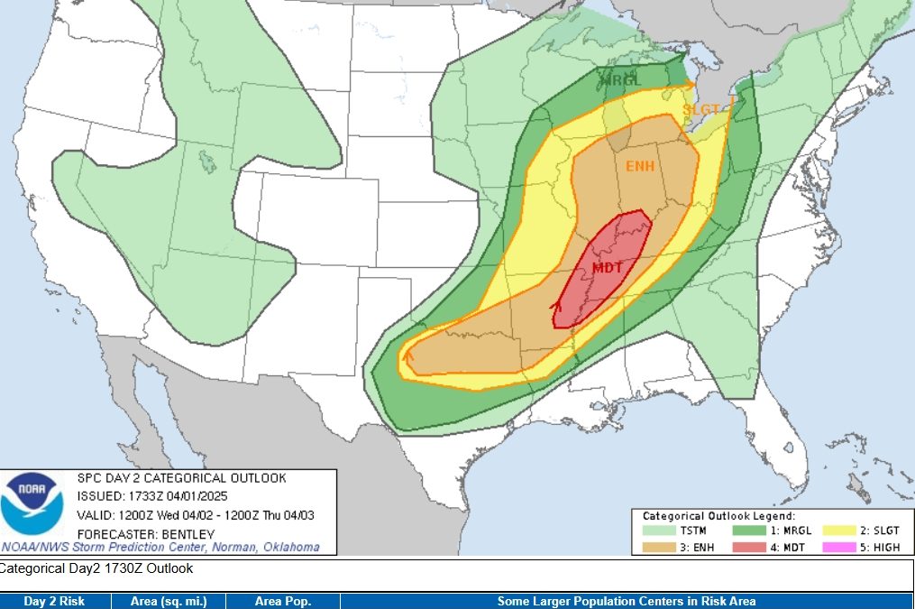
Severe Weather Outlook: Dangerous Storms Expected April 2nd
What This Map Is Showing
This is the Severe Weather Outlook from the Storm Prediction Center (SPC) for Wednesday, April 2nd.
Map Breakdown
The different shaded colors on the map represent how likely and how serious the threat of severe weather is tomorrow in different areas:
| Color | Risk Level | What It Means |
|---|---|---|
| Dark Green | Marginal Risk | Isolated strong storms are possible. Not everyone will see a storm. |
| Yellow | Slight Risk | A few strong to severe storms are likely. Hail, wind, or even a weak tornado is possible. |
| Orange | Enhanced Risk | More organized and widespread severe storms are expected. Some tornadoes and damaging winds are likely. |
| Red | Moderate Risk | A dangerous severe weather day is likely. Strong tornadoes, large hail, and destructive winds are all possible. |
Areas in red (Moderate Risk) include Memphis, TN, Evansville, IN, and Little Rock, AR.
In Simple Terms: What’s Going On?
A powerful storm system is moving through the central United States
- A strong weather disturbance in the upper atmosphere will move across the Plains into the Midwest.
- At the same time, warm, humid air from the Gulf of Mexico is pushing northward.
- The collision of these systems will create the right environment for severe thunderstorms to form, especially from East Texas and Arkansas up into Illinois and Indiana.
What Kind of Storms Are We Talking About?
- Supercells — These are powerful rotating storms that can:
- Produce very large hail
- Create damaging wind gusts
- Spawn tornadoes, including some strong ones (especially in the red Moderate Risk area)
- Squall Line or Line of Storms — Later in the night, storms may form a big line of thunderstorms that can:
- Move quickly and cover wide areas
- Bring strong, damaging winds
- Still possibly produce tornadoes
Who Should Be Most Concerned?
People living in the Moderate Risk area (in red) — particularly:
- Memphis, TN
- Evansville, IN
- Little Rock, AR
- Paducah, KY
- Jonesboro, AR
These areas are under the highest risk for dangerous severe weather tomorrow — including tornadoes, hail larger than golf balls, and very strong wind gusts.
Technical Summary — In Easy Language
- A “negatively tilted trough” is a storm system that is angled in a way that helps storms spin and strengthen.
- A “surface low pressure system” acts like a vacuum at ground level, pulling in warm, moist air that fuels storms.
- A “low-level jet” refers to strong winds just above the ground, which help tilt and rotate storms, increasing the tornado threat.
- CAPE (Convective Available Potential Energy) is the amount of energy available for storms. High CAPE means the atmosphere has a lot of storm fuel.
What You Should Do If You’re in the Risk Area
- Stay aware of weather alerts, especially Wednesday afternoon through the evening.
- Have multiple ways to receive warnings, such as:
- A NOAA Weather Radio
- Wireless emergency alerts on your phone
- Local TV or weather apps
- Know where to go if a warning is issued — ideally a basement or small, windowless interior room.
- Charge your phone and prepare flashlights or backup power in case of outages.
- Take watches and warnings seriously — the threat is real, and preparation saves lives.
Final Takeaway
A serious storm system is expected Wednesday, April 2. If you live in the Mid-South, Mid-Mississippi Valley, or Lower Ohio Valley, be ready. This could be a high-impact severe weather day with tornadoes, strong winds, and large hail. Staying alert and having a plan will help protect you, your family, and your property.

