Major Winter Storm to Bring Heavy Snow Across Arkansas, Tennessee, and Northern Mississippi – January 2025 Forecast
A significant winter storm system is approaching the Mid-South region, with the National American Model (NAM) forecasting substantial snowfall accumulations. Here’s what residents need to know about this updated winter weather forecast.
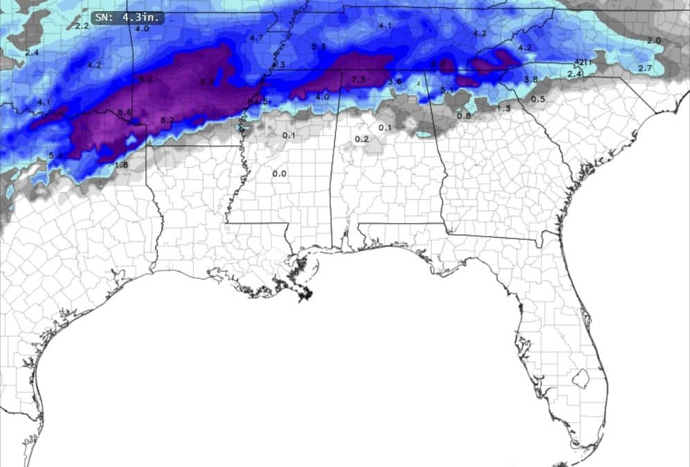
Where Will the Heaviest Snow Fall?
Central and Eastern Arkansas are now expected to bear the brunt of this winter storm, with widespread snowfall totals of 6-8 inches forecast. The heavy snow band extends through West Tennessee and into extreme Northern Mississippi, creating potentially hazardous travel conditions across the tri-state area.
City-by-City Snow Forecast
Arkansas Snow Totals:
- Little Rock: 6-8 inches expected
- Jonesboro: 4-6 inches expected
- Pine Bluff: 6-7 inches expected
- Northwestern Arkansas: 3-4 inches expected
Tennessee Snow Totals:
- Memphis: 4-7 inches expected
- Jackson: 3-6 inches expected
- Nashville: 2-3 inches expected
Mississippi Snow Totals:
- Tupelo: 4-6 inches expected
- Oxford: 4-5 inches expected
- Southaven: 6-7 inches expected
What Should Residents Do to Prepare?
- Stock up on essential supplies before the storm arrives
- Plan to work from home if possible when the snow begins
- Avoid unnecessary travel during the heaviest snowfall
- Keep emergency supplies in your vehicle if travel is essential
- Stay updated with local weather forecasts and emergency information
Frequently Asked Questions
When will the snow start?
I believe it could start as early as late Thursday afternoon in Arkansas.
Will schools be closed?
Given the forecast snowfall amounts, school closures are likely in areas expecting six or more inches of snow, particularly in Central/Eastern Arkansas and West Tennessee.
How will this impact travel?
Travel conditions will become hazardous across the entire region, with Interstate 40 between Little Rock and Memphis and Interstate 55 through Northern Mississippi likely to be significantly impacted.
Tips for Staying Safe During the Winter Storm
- Keep your mobile devices charged
- Have alternate heating sources ready in case of power outages
- Check on elderly neighbors and relatives
- Bring pets indoors
- Monitor local news and weather updates
Areas of Greatest Impact
The heaviest snow band is expected to set up from Central Arkansas, through Eastern Arkansas, across West Tennessee, and into extreme Northern Mississippi. This area could see significant accumulations that may disrupt daily activities and travel. Areas north and south of this band will see sharply lower amounts.
This winter storm system represents a significant weather event for the Mid-South region, with potentially dangerous travel conditions and substantial snowfall accumulations. Residents should closely monitor local forecasts and prepare accordingly.
Great information, John!
Thank you, Trey!
So what’s your prediction on it for the midsouth
I don’t see any the first two weeks of March. For what it’s worth, the European model today does have some Snow in Northwest Arkansas on St Patrick’s Day. Any model that far out almost always changes several times.