Mid-South Winter Storm: 6+ Inches Snow, Ice Expected This Weekend
Last Updated: Tuesday, January 21, 2026, at 3:22 PM CST by John Bryant
Sources include NWS Memphis
| Affected Region | Mid-South (Tennessee, North Mississippi, East Arkansas) |
|---|---|
| Event Start | Friday afternoon as temperatures drop below freezing |
| Heaviest Period | Friday night through Saturday |
| Event End | Early Sunday afternoon |
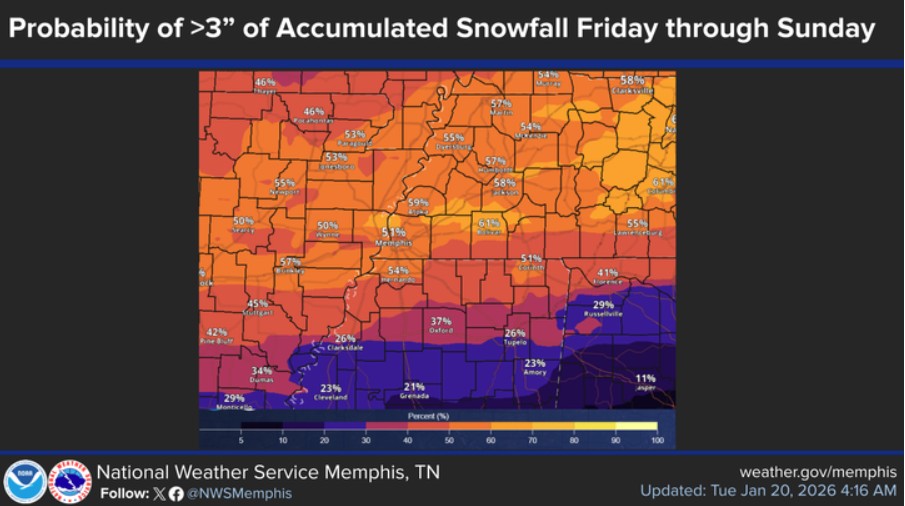
| Snow (I-40 & North) | 50-70% chance of 3″+; 30-50% chance of 6″+ |
| Ice (N. Mississippi) | 30-50% chance of ¼”+ accumulation |
| Temperatures | Air temps: 10s-20s; Wind chills: Teens to single digits |
| Duration of Cold | Below freezing through at least Monday; recovery hindered through mid-week |
| Data Source | National Weather Service Memphis (1:08 PM CST Tuesday) |
Key Messages from the National Weather Service
🌨️ Heavy Snow, Sleet, and Ice: An impactful winter storm will affect the Mid-South beginning Friday afternoon, continuing through Sunday morning.
❄️ Bitterly Cold Air: Dangerous cold will accompany the wintry precipitation and last into early next week. Wind chills will reach the teens and single digits.
🌧️ Wednesday Rain: Light rain is expected Wednesday with only a quarter to half-inch of accumulation. Less than 20% chance of any wintry precipitation—no travel impacts expected.
Current Conditions and Today’s Outlook
Calm weather continues across the Mid-South today as an upper-level weather pattern keeps northwesterly winds flowing over the central United States. A minor weather system currently over British Columbia will move southeast and bring a cold front through our area tonight.
This front will bring increasing moisture late tonight into Wednesday morning, but temperatures will remain too warm for any winter weather concerns tonight.
Wednesday: Light Rain, No Winter Weather Impacts
Rain showers will develop around sunrise Wednesday across eastern Arkansas and spread eastward throughout the day across the entire Mid-South region.
Will There Be Winter Weather Wednesday?
No significant wintry precipitation is expected Wednesday. Some computer forecast models showed a slight possibility of light freezing rain or snow showers across eastern Arkansas tonight. However, detailed forecast analysis shows the significant majority of scenarios keep temperatures above freezing from the surface up to about 5,000 feet, which eliminates serious concerns for wintry precipitation before sunrise.
After sunrise Wednesday, surface temperatures will rise well above freezing. Only plain rain is expected across the region with light accumulations of a quarter to half-inch at most.
The rain will end by sunrise Thursday as the cold front moves east of the region. Dry weather will follow Thursday as high pressure builds in behind the front, bringing mild afternoon temperatures—a brief respite before Friday’s significant storm.
SERVICES FORENSIC METEOROLOGISTS PROVIDE AFTER THE STORM
The Major Event: Friday Through Sunday Winter Storm
A much stronger cold front—significantly more intense than Wednesday’s system—will move south across the Midwest into Friday, setting the stage for an impactful winter storm across the Mid-South.
⚠️ Timeline: When Conditions Deteriorate
Friday Morning: The cold front will reach the Mid-South. Temperatures will quickly drop below freezing by mid-afternoon as arctic air rushes in behind the front.
Friday Afternoon: Precipitation will begin as temperatures fall below freezing. Initial precipitation types depend on location (see details below).
Friday Night Through Saturday: The heaviest snow, sleet, and ice will occur during this period. Precipitation intensity will increase through Friday night.
Sunday Morning: Precipitation will taper off and end by early Sunday afternoon.
The Arctic Lock: Why It Will Stay So Cold
Behind Friday’s cold front, an extremely strong surface high pressure system—exceeding 1045 millibars—will move into the northern United States. This is an exceptionally strong high pressure area that will effectively lock arctic air in place at the surface across the Mid-South.
This strong high pressure will continue pushing cold air into our region throughout the weekend, preventing any warming. Think of it as a massive dome of arctic air settling over the region and refusing to budge for several days.
Understanding the Atmospheric Setup
This winter storm will develop from a complex interaction between arctic air at the surface and moisture flowing in from the Pacific Ocean and Gulf of Mexico. Here’s how the pieces come together:
The Moisture Source
While Friday’s cold front moves across the country, a large area of energy will descend along the Pacific coastline, creating an upper-level low pressure system off the coast of California. This system will allow moisture from the Pacific to move over Mexico and into the southern United States.
This moisture will arrive at exactly the right time to interact with the cold front aloft on Friday. Computer forecast models show this moisture being lifted upward and producing precipitation as early as Friday afternoon, with intensity increasing through Friday night.
The Temperature Profile: Why All Types Are Possible
The vertical temperature structure Friday will feature an increasingly deep layer of below-freezing air at the surface, with temperatures remaining above freezing between about 5,000 and 10,000 feet in the atmosphere.
This specific temperature profile is critical because it allows all modes of wintry precipitation: snow, freezing rain (ice), and sleet. The exact type you experience will depend on your location and how the temperature layers evolve.
Saturday: Intensification
The upper-level weather system off the west coast will merge with another system entering the northwestern United States, pulling the entire complex eastward. This will increase the flow of warm, moist air from the Gulf of Mexico northward into Saturday.
Forecast models now show a distinct area of surface low pressure developing south of the Mid-South on Saturday. All these factors combined will intensify the forcing for precipitation Saturday, with an expansive area of heavy snow, sleet, and ice occupying the entire region.
This is when the storm reaches its peak intensity and delivers the heaviest precipitation.
Expected Snow and Ice Accumulations
Forecast details have come into much clearer focus over the past 24 hours. Yesterday, the American (GFS) and European (ECMWF) forecast models differed significantly on precipitation amounts. Overnight, these models have come into much better agreement, increasing confidence in the forecast.
❄️ Snowfall: Along and North of I-40
Both major forecast models now agree: a swath of 6+ inches of snow is probable along Interstate 40.
Forecast Probabilities (National Blend of Models):
- 3 or more inches: 50-70% probability along and north of I-40
- 6 or more inches: 30-50% probability along and north of I-40
What This Means: The Memphis metro area, Jackson (Tennessee), and areas northward into Kentucky are in the highest probability zone for significant snowfall. Six-inch snow accumulations are well within the realm of possibility for these areas.
Remaining Uncertainty: The exact location of the heaviest snow axis—where the absolute maximum accumulations will occur—is still being refined. This will become clearer in the next 24-48 hours.
🧊 Ice Accumulation: Northern Mississippi
South of the snowfall axis, significant ice or sleet accumulation is expected.
Forecast Probabilities:
- At least ¼ inch of ice: 30-50% probability across northern Mississippi and areas south of I-40
Ice vs. Sleet: The Critical Question
One key uncertainty is whether this area will receive primarily freezing rain (which creates ice) or sleet (which acts more like snow). The difference matters significantly:
- Freezing Rain (Ice): Coats power lines, tree branches, and all surfaces. Quarter-inch ice accumulation is enough to cause widespread power outages and make roads impassable.
- Sleet: Acts more like snow, creating hazardous road conditions but less likely to damage power infrastructure.
The determining factor will be the depth of the below-freezing layer behind the cold front and how far south it extends before the upper-level moisture arrives. Forecast models are currently split on this question.
One thing is certain: significant impacts can be expected from both scenarios—whether related to road infrastructure (sleet) or power infrastructure (ice).
Geographic Breakdown
Memphis, TN Metro & Areas North:
- Primarily snow
- Highest probability for 6+ inch accumulations
- Travel will be extremely hazardous or impossible
Northern Mississippi (Southaven, Olive Branch, Tupelo):
- Mix of sleet and freezing rain likely
- Significant ice accumulation possible
- Power outages probable if ice forms
- Roads will be extremely dangerous
Transition Zone (I-40 Corridor):
- Complex mix of all precipitation types possible
- Precipitation type may change multiple times
- Both snow and ice impacts expected
The Bitterly Cold Aftermath
Precipitation will diminish Sunday morning as the storm system moves away, with most areas becoming dry by early Sunday afternoon. However, the dangerous cold will be just beginning.
🥶 Extreme Cold: Friday Night Through Early Next Week
Air Temperatures: Dropping into the 10s and 20s Friday night through early next week.
Wind Chills: Will feel like the teens and single digits above zero due to northerly winds.
Duration: Temperatures will remain below freezing through at least Monday. This means any snow or ice on the ground will not melt.
Recovery Impact: Road clearing and power restoration efforts may be hindered through the middle of next week due to the persistent cold. Any melting during the day will refreeze at night, creating prolonged hazardous conditions.
The forecast remains dry Sunday through the middle of next week despite the cold. This is a silver lining—no additional precipitation will compound the existing problems. However, the cold will make recovery slow and difficult.
Preparation Timeline: What to Do and When
You have until Thursday evening to prepare. After that, worsening conditions will make preparation difficult or impossible.
📅 Tuesday-Wednesday: Begin Preparation
Stock Essential Supplies:
- Non-perishable food for 5-7 days (assume no grocery trips)
- One gallon of water per person per day (7-day supply recommended)
- All prescription medications with at least one week supply
- Pet food and supplies
- Baby formula, diapers, and supplies if applicable
- Batteries, flashlights, battery-powered or hand-crank radio
- First aid kit and basic tools
- Portable phone chargers and power banks (charge fully)
Home Preparation:
- Locate your main water shut-off valve (in case pipes freeze/burst)
- Test your sump pump if you have one
- Clear gutters and downspouts
- Bring in outdoor furniture, decorations, plants
- Trim dead tree branches that could fall on power lines
📅 Thursday: Final Preparation Day
This is your last opportunity to prepare. Complete everything by Thursday evening.
Critical Tasks:
- Fill all vehicle gas tanks (gas stations may lose power)
- Withdraw cash (ATMs may not work during power outages)
- Charge all devices: phones, tablets, laptops, power banks, flashlights
- Do all laundry (you may not have power for days)
- Wash dishes, clean kitchen
- Fill bathtubs with water (for toilet flushing if water pressure fails)
Pipe Protection (Critical for This Event):
- Insulate all exposed water pipes, especially on exterior walls
- Seal cracks and openings in exterior walls near pipes
- Open cabinet doors under sinks to allow warm air circulation
- Disconnect and drain outdoor hoses
- Insulate outdoor faucets and hose bibs
- Know where your water shut-off is located
Heating Preparation:
- Service your furnace (change filter at minimum)
- Have alternative heating sources ready (ensure proper ventilation)
- Stock firewood if you have a fireplace
- Test your generator if you have one (run outside only, never in garage)
- Weatherstrip doors and windows
- Have heavy blankets readily accessible
Vehicle Preparation:
- Check antifreeze level and tire pressure
- Keep gas tanks full (at least ¾ tank)
- Place emergency kit in vehicle: blankets, water, snacks, jumper cables, flashlight, small shovel, ice scraper
- Clear your schedule Friday through Sunday—plan to stay home
📅 Friday-Sunday: Shelter in Place
AVOID ALL TRAVEL. This cannot be stressed enough.
- Stay home: Snow, sleet, and ice will make roads impassable. Even experienced winter drivers cannot safely navigate these conditions.
- Monitor local media: Watch for Winter Storm Warnings, Ice Storm Warnings, and Wind Chill Advisories.
- Let faucets drip: A small trickle from faucets on exterior walls helps prevent frozen pipes.
- Keep interior doors open: Allow heat to circulate throughout your home.
- If power fails: Close off unused rooms, gather in one central room, use blankets and layers rather than alternative heat sources that could cause carbon monoxide buildup.
- Never use generators indoors: Carbon monoxide kills. Run generators outside only, at least 20 feet from your home.
- Check on neighbors: Especially elderly residents and those with medical conditions.
- Report power outages: Call your utility company to report outages so they can prioritize restoration.
📅 Sunday-Next Week: Recovery Phase
- Beware of refreezing: Even if temperatures rise slightly during the day, overnight lows will cause melting snow and ice to refreeze, creating black ice on roads.
- Remove snow from roofs carefully: Heavy snow can stress roof structures. Use a roof rake from the ground if possible.
- Clear storm drains: Melting snow needs drainage paths. Blocked drains cause localized flooding.
- Be patient with utilities: Power restoration may take several days if ice damages trees and lines.
- Check for frozen pipes: If a faucet produces no water, that pipe may be frozen. Do not attempt to thaw with open flame.
- Document damage: Take photos of any property damage for insurance claims.
Frequently Asked Questions
How much snow will the Mid-South get this weekend?
Areas along and north of Interstate 40 have a 50-70% chance of receiving 3+ inches of snow, with a 30-50% chance of 6+ inches. The Memphis metro area is in the heaviest snowfall zone.
When will the winter storm start?
Precipitation will begin Friday afternoon as temperatures drop below freezing. The heaviest snow and ice will fall Friday night through Saturday, ending by early Sunday afternoon.
Will there be ice accumulation?
Yes. Areas south of the I-40 corridor, particularly northern Mississippi, have a 30-50% chance of at least a quarter-inch of ice accumulation. This could cause significant power outages.
How cold will it get after the storm?
Bitterly cold. Air temperatures will drop into the 10s and 20s with wind chills in the teens and single digits Friday night through early next week. Temperatures will stay below freezing through at least Monday.
Is Wednesday’s rain a concern?
No. Wednesday will bring only light rain with a quarter to half-inch of accumulation. The chance of any wintry precipitation Wednesday is less than 20 percent and would not cause travel impacts.
When should I complete storm preparation?
Complete all preparation by Thursday evening. Stock up on essentials, protect pipes, charge devices, and fill gas tanks by Thursday. Avoid all travel Friday afternoon through Sunday.
What Makes This Forecast More Certain Now
Confidence in this forecast has increased significantly over the past 24 hours due to improved agreement between major forecast models:
- Model Convergence: The American (GFS) and European (ECMWF) models now show similar solutions for precipitation amounts and distribution.
- Surface Low Development: Models now consistently show a surface low pressure developing south of the region Saturday, which will intensify precipitation.
- Snowfall Probabilities: The National Blend of Models and ensemble guidance have increased snowfall probabilities along I-40.
- Arctic High Strength: All models agree on an exceptionally strong surface high (1045+ mb) that will lock cold air in place.
Remaining Uncertainties:
- Exact location of the heaviest snow axis
- Whether northern Mississippi receives primarily freezing rain or sleet
- Precise amounts at specific locations (this will be refined in coming days)
When to Expect Updates and Warnings
The National Weather Service will issue formal watches and warnings as this event approaches:
Winter Storm Watch: Expected to be issued Wednesday or Thursday, 24-48 hours before onset. This means conditions are favorable for significant winter weather.
Winter Storm Warning: Will be issued Thursday night or Friday morning when winter weather is imminent or occurring. This means take action now—dangerous conditions are occurring or about to occur.
Ice Storm Warning: May be issued for areas expecting significant ice accumulation (quarter-inch or more).
Check for forecast updates:
- Wednesday morning and evening
- Thursday morning and evening
- Friday morning (final update before event begins)
Forecasters will refine specific accumulation amounts, timing, and precipitation type boundaries as new data becomes available. The overall pattern is now well-established, but details will continue to improve.
Summary: What You Need to Know
- Impactful winter storm Friday afternoon through Sunday morning
- 6+ inches of snow probable along I-40; significant ice possible in northern Mississippi
- Bitterly cold air with wind chills in single digits will follow
- Temperatures staying below freezing through at least Monday
- Complete all preparation by Thursday evening
- Avoid travel Friday through Sunday
- Power outages likely; prepare for extended outages
- Recovery efforts hindered by cold through mid-week
This is a significant winter weather event for the Mid-South. The combination of heavy snow, ice, and dangerous cold makes this a potentially dangerous situation. Take preparation seriously and complete all tasks by Thursday evening.
Data Sources and Forecast Methodology
This forecast analysis is based on the National Weather Service Memphis office’s 1:08 PM CST Tuesday, January 21, 2026 forecast discussion and includes:
- Model Guidance: GFS (Global Forecast System), ECMWF (European model), HREF (High-Resolution Ensemble Forecast), NBM (National Blend of Models), LREF ensemble
- Surface Analysis: Current and forecast surface high pressure systems (1045+ mb)
- Upper Air Analysis: Upper-level troughs, shortwave energy, and jet stream patterns
- Atmospheric Soundings: Vertical temperature profiles determining precipitation types
- Probability Guidance: NBM and LREF snowfall and ice probabilities
- Ensemble Analysis: Multiple model runs to assess forecast uncertainty
Forecast confidence assessments are based on model agreement, ensemble spread, and historical performance for similar weather patterns. Updates to this forecast will be issued twice daily through Friday as new data refines details.
Need Expert Weather Analysis?
For legal cases, insurance claims, or forensic weather reconstruction, contact me for a professional consultation.
Weather Resources & Warnings
Official Weather Information:
- National Weather Service Memphis (Current Warnings & Forecasts)
- National Weather Service (All Offices)
- NOAA (National Oceanic and Atmospheric Administration)
Emergency Preparedness & Safety:
This forecast is for informational purposes based on National Weather Service data. Always follow official warnings and advisories from the National Weather Service for your specific location. For forensic weather analysis or legal consultation, contact a qualified meteorologist expert witness.