Here are the key changes with the most recent update from the Storm Prediction Center
Key Changes in the Afternoon Update from the Storm Prediction Center (SPC)
1️⃣ The Forecast is Mostly the Same, But the Storm is Taking Shape
- The overall storm outlook hasn’t changed much, but now we have better details on storm development as the system continues to strengthen.
- A strong storm system is moving out of Texas and rapidly organizing over the Lower Mississippi Valley (Arkansas, Louisiana, Mississippi, Tennessee).
2️⃣ Increasing Risk for Damaging Winds & Tornadoes
- A powerful cold front is pushing into Arkansas, helping storms form more quickly.
- Winds high in the atmosphere (55-75 mph at 10,000 feet up) will help push storms into a long, intense line—bringing widespread damaging wind gusts and the chance for quick spin-up tornadoes within the storm line.
3️⃣ Tornado Potential: Watching for Isolated Supercells Before the Main Storm Line
- Some areas in eastern Arkansas, northwestern Mississippi, and southwestern Tennessee may get stronger heating this afternoon, which could help a few isolated supercell storms form ahead of the main squall line.
- Why this matters:
- If these storms form, they could produce stronger tornadoes since wind shear (wind changing speed and direction with height) is extremely strong in this area.
- This part of the forecast remains uncertain, but if isolated supercells develop, they could be especially dangerous.
4️⃣ Gulf Coast Impact Late Tonight
- The main storm line will race eastward late tonight, impacting Mississippi, Alabama, and parts of the Florida Panhandle.
- There’s a small chance for tornadoes ahead of the storm line, but confidence is low because the atmosphere isn’t as supportive for isolated storms.
- The primary threat overnight will be damaging wind gusts and tornadoes embedded within the storm line.
Bottom Line: What’s New?
✔️ Storms are starting to take shape with strong winds and a rapidly developing cold front.
✔️ Tornado potential is increasing, especially if a few isolated storms develop ahead of the main line in eastern Arkansas, northwestern Mississippi, and southwestern Tennessee.
✔️ The squall line will be intense, bringing widespread damaging wind gusts and possible tornadoes overnight.
✔️ The Gulf Coast is still at risk later tonight, but the potential for isolated tornadoes there remains uncertain.
What’s Happening?
A severe weather outbreak is expected today from eastern Texas through the Lower Mississippi Valley and into the Southeast. This means parts of Louisiana, Mississippi, Alabama, Tennessee, and Georgia are at risk for dangerous storms.
- The biggest threats:
- Tornadoes – Some could be strong (EF2 or higher).
- Damaging winds – Widespread power outages and fallen trees are possible.
- Heavy rain and localized flooding in some areas.
Storms will develop this afternoon (around 2-4 PM Central Time) and will continue through the overnight hours. It should be noted that it will not storm everywhere this bad in the risk areas, but ALL of those in the risk areas have the chance.
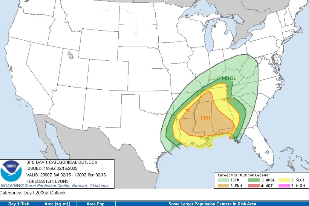
Understanding the Map: What Do the Colors Mean?
The Storm Prediction Center (SPC) uses different colors to show how serious the risk is:
🟢 Marginal Risk (Green) – Isolated storms are possible, but widespread damage is unlikely. Some strong winds or an isolated tornado could occur.
🟡 Slight Risk (Yellow) – More storms, more intense. A few tornadoes and damaging wind gusts are possible.
🟠 Enhanced Risk (Orange) – This is serious. Many strong storms are expected, with the potential for multiple tornadoes and widespread damaging winds. This is the area most at risk for dangerous weather today.
Who is in the highest-risk zones today?
- Memphis, TN | Mobile, AL | Jackson, MS | Tuscaloosa, AL (Enhanced Risk)
- Nashville, TN | New Orleans, LA | Montgomery, AL | Baton Rouge, LA (Slight Risk)
- Atlanta, GA | Chattanooga, TN | Little Rock, AR (Marginal Risk)
What to Expect & When
2️⃣ Afternoon (2-4 PM CST):
- Severe storms begin forming in eastern Texas, Louisiana, and Arkansas.
- Tornadoes could begin in these areas.
3️⃣ Evening (5-9 PM CST):
- Stronger storms move into Mississippi, Tennessee, and Alabama.
- A line of storms (squall line) develops, bringing strong winds and tornadoes.
4️⃣ Overnight (10 PM – 4 AM CST):
- The storm line moves east into Alabama and Georgia.
- Tornadoes at night are especially dangerous because people are sleeping.
How to Stay Safe
✔️ Have multiple ways to receive alerts (Weather radio, phone alerts, TV).
✔️ Charge devices now in case of power outages.
✔️ Know your safe place – A basement or interior room with no windows.
✔️ Stay aware even after dark – Tornadoes overnight can be deadly if people aren’t paying attention.
Bottom Line:
- The most dangerous storms will hit in the Lower Mississippi Valley and Southeast this afternoon and evening.
- Strong tornadoes and damaging winds are the biggest risks.
- If you’re in an orange or yellow zone, be weather-aware and prepared for possible tornadoes and damaging winds.
If you ever need a weather expert witness for litigation, you can contact one here