Mid-South Winter Storm This Weekend: Snow, Ice, Frigid Temps Expected
Last Updated: Tuesday, January 20, 2026, at 11:51 AM CST
| Affected Area | Mid-South (Tennessee, North Mississippi, East Arkansas) |
|---|---|
| Primary Event Window | Friday Night – Saturday (Jan 24-25, 2026) |
| Expected Precipitation Types | Snow (I-40 corridor north), Sleet & Ice (central MS south) |
| Post-Storm High Temps | Near or below 30°F (weekend) |
| Post-Storm Low Temps | Single digits to low teens |
| Forecast Confidence | Medium for winter impacts (50-70%), High for frigid temps (>80%) |
| Data Source | National Weather Service Memphis (00Z Tuesday analysis) |
Current Conditions and Short-Term Outlook
Very cold air has settled over the Mid-South this evening. A strong high-pressure system centered over the Southern Plains is pumping arctic air into the region, with late evening temperatures already dropping into the teens north of Interstate 40 and into the 20s to the south.
Overnight lows tonight will reach the teens to lower 20s region-wide as clear skies allow heat to radiate away from the surface. This cold snap is temporary. By Tuesday afternoon, the high-pressure system will shift eastward into the Tennessee Valley, bringing southerly winds that will warm temperatures back into the 40s across most areas.
HOW FORENSIC METEOROLOGISTS HELP AFTER A STORM
Wednesday’s Rain Event: Minor Winter Weather Concern
A weather system will bring moisture back to the Lower Mississippi Valley late Tuesday night into Wednesday. Rain showers are expected to develop around sunrise Wednesday and spread across the area during the day.
Winter Weather Potential on Wednesday: Very low. Computer forecast models show less than 20% probability for a brief period of sleet mixing with rain as precipitation begins. However, temperatures are expected to warm above freezing quickly, preventing any accumulation or travel impacts.
Rainfall amounts from this system will range from one-tenth to one-quarter inch north of Interstate 40, and one-third to three-quarters of an inch to the south. This rain will move out Wednesday night, setting the stage for Friday’s much more significant event.
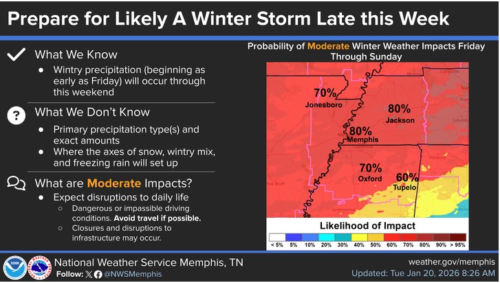
The Main Event: Weekend Winter Storm
Multiple forecast models agree: a strong arctic cold front will drop into the Central United States on Friday and bring significant winter precipitation to the Mid-South this weekend. This is a high-impact weather event that requires preparation.
Precipitation Types and Distribution
The type of winter precipitation you receive depends primarily on your location relative to Interstate 40:
- Along and North of I-40: Primarily snow. The Memphis metro, Jackson (TN), and areas northward have the highest probability for accumulating snowfall.
- Central Mississippi: A mix of sleet and freezing rain becomes more likely. Ice accumulation is a greater concern in this zone.
- Transition Zones: Areas between these regions will likely see a mix of all precipitation types as temperatures fluctuate near the freezing mark.
Timing: Still Being Refined
Forecast models disagree on when precipitation will begin:
- Earlier Scenario (GFS Model): Precipitation develops as early as sunrise Friday and continues through Saturday.
- Later Scenario (ECMWF Model): A dry period exists through much of Friday, with precipitation developing Friday night and spreading across the region Saturday.
Current Assessment: The exact timing will be refined as the event approaches. Assume precipitation could begin anytime Friday and plan accordingly.
Model Trends and Forecast Confidence
Recent forecast model runs show improving agreement on the overall pattern. The latest GFS model has shifted northward to align better with the European (ECMWF) model and ensemble solutions. This convergence increases confidence in the general forecast scenario.
However, specific details about precipitation amounts and exact boundaries between snow, sleet, and ice zones will continue to be adjusted as new data becomes available. Check for updates twice daily.
Dangerous Cold Following the Storm
Perhaps the most certain aspect of this forecast is the extreme cold that will follow the winter precipitation. Forecasters have high confidence (greater than 80%) that frigid temperatures will grip the region next weekend and persist into early next week.
Expected Temperatures:
- High Temperatures: Struggling to reach 30°F on Saturday and Sunday. Many areas may remain below freezing all day.
- Low Temperatures: Single digits above zero to low teens Saturday night through Monday morning. These will be among the coldest temperatures in several years for the Mid-South.
The combination of winter precipitation on the ground, strong arctic high pressure, and clear skies will allow excellent radiational cooling at night. Any melting during the day will refreeze at night, creating hazardous conditions that persist for days.
Preparation Guidance
Given the medium-to-high confidence in this winter weather event, preparation should begin immediately. Here’s what you need to do:
Before the Storm (Complete by Thursday Evening)
Stock Essential Supplies:
- Non-perishable food for at least 3-5 days
- Bottled water (one gallon per person per day)
- Prescription medications with at least a week’s supply
- Batteries, flashlights, and battery-powered or hand-crank radio
- First aid kit and basic tools
Protect Your Home:
- Insulate exposed water pipes, especially those on exterior walls
- Know the location of your main water shut-off valve
- Seal drafts around windows and doors
- Have alternative heating sources ready (ensure proper ventilation)
- Charge all electronic devices and portable power banks
Vehicle Preparation:
- Fill gas tanks by Thursday
- Check antifreeze levels and tire pressure
- Place emergency kit in vehicle (blankets, water, snacks, jumper cables)
- Clear schedule for Friday through Sunday—avoid unnecessary travel
During the Event (Friday–Sunday)
- Avoid travel: Snow, sleet, and ice make roads extremely dangerous. Even experienced winter drivers struggle in these conditions.
- Monitor local media: Watch for Winter Storm Warnings, Ice Storm Warnings, and Wind Chill Advisories from the National Weather Service.
- Conserve heat: If power is lost, close off unused rooms and gather in one central room.
- Let faucets drip: A slight trickle from faucets on exterior walls helps prevent frozen pipes.
- Check on neighbors: Especially elderly residents and those with health conditions.
After the Storm (Next Week)
- Watch for refreezing: Even if temperatures rise slightly during the day, overnight lows will cause standing water and melted snow to refreeze, creating black ice.
- Remove snow from roofs: Heavy, wet snow can stress roof structures, especially when followed by more precipitation.
- Clear storm drains: Melting snow needs somewhere to go. Blocked drains can cause localized flooding.
- Be patient with utilities: Power restoration may take time, especially if ice damages trees and power lines.
Frequently Asked Questions About This Winter Storm
When will the winter storm hit the Mid-South?
The most significant winter precipitation is expected Friday night through Saturday, with exact timing still being refined. Prepare by Thursday evening to be safe.
What types of winter precipitation are expected?
Snow is favored along and north of Interstate 40, while areas toward central Mississippi may see more sleet and ice accumulation. Mix zones will exist between these areas.
How cold will it get after the storm?
Extremely cold. High temperatures next weekend will struggle to reach 30°F, with overnight lows dropping into the single digits to low teens across most of the region.
Should I be concerned about the Wednesday rain?
No significant winter weather impacts are expected Wednesday. A brief period of sleet may mix with rain initially, but temperatures will warm above freezing quickly.
How confident are forecasters about this winter storm?
The National Weather Service reports medium confidence (50-70%) for winter weather impacts and high confidence (greater than 80%) for frigid temperatures following the storm.
What should I do to prepare?
Stock up on essential supplies by Thursday, prepare your home for extended cold, protect outdoor pipes, ensure you have alternative heat sources, and avoid travel Friday night through the weekend if possible.
What to Expect in Coming Updates
Forecast details will continue to be refined as this winter storm approaches. Key questions that will be answered in subsequent updates include:
- Exact timing: When will precipitation begin in each area?
- Specific accumulations: How much snow, sleet, or ice should each location expect?
- Precipitation type boundaries: Where exactly will the line between predominantly snow and predominantly ice fall?
- Duration: How long will winter precipitation persist in each area?
Check back for updates at least twice daily—Wednesday morning, Wednesday evening, Thursday morning, Thursday evening, and Friday morning at a minimum. The National Weather Service will issue Winter Storm Watches 24-48 hours before the expected onset, followed by Winter Storm Warnings when confidence increases.
Bottom Line Recap
- Significant winter storm expected Friday night through Saturday
- Snow favored north of I-40; ice and sleet more likely in central Mississippi
- Dangerous cold follows with highs near 30°F and lows in single digits to teens
- Complete all preparation by Thursday evening
- Avoid travel Friday through Sunday; expect hazardous road conditions that persist for days
This is a potentially significant winter weather event for the Mid-South. Take it seriously and prepare now.
Data Sources and Methodology
This forecast is based on the National Weather Service Memphis office’s 00Z (6:00 PM CST) Tuesday, January 21, 2026 forecast discussion. Analysis includes:
- Upper Air Analysis: 00Z standard atmospheric soundings and wind profiles
- Surface Analysis: Observed surface high pressure (1032 mb) over Southern Plains
- Model Guidance: GFS (Global Forecast System), ECMWF (European model), and ensemble solutions
- Model Run Times: 00Z Tuesday (latest), compared with 12Z and 18Z runs
- Regional Focus: Mid-South area including Tennessee, North Mississippi, and East Arkansas
Forecast confidence levels are provided by the National Weather Service based on model agreement and historical performance for similar weather patterns. Medium confidence (50-70%) indicates reasonable agreement among models but some uncertainty in specific details. High confidence (>80%) indicates strong model agreement and high likelihood of occurrence.
Need Expert Weather Analysis?
For legal cases, insurance claims, or forensic weather reconstruction, contact me for a professional consultation.
Weather Resources
Official Weather Data & Forecasts:
- National Weather Service Memphis
- National Oceanic and Atmospheric Administration (NOAA)
- National Weather Service
- Storm Prediction Center
Emergency Preparedness:
This forecast is for informational purposes based on National Weather Service data. Always follow official warnings and advisories from the National Weather Service for your specific location. For forensic weather analysis or legal consultation, contact a qualified meteorologist expert witness.