2026 Nebraska Wildfires: Forensic Weather Reconstruction for Litigation
By John Bryant, AMS/NWA/EPA-Certified Forensic Meteorologist | Published 2026-03-19 | Last Updated 2026-03-19
| Location | Western and Central Nebraska (CONUS, Great Plains). Morrill, Garden, Arthur, Keith, Grant, Dawson, Lincoln, Frontier, Thomas, Blaine, and Cherry Counties. State of emergency declared for Morrill, Garden, Arthur, Keith, Lincoln, Dawson, and Frontier Counties. |
|---|---|
| Time Window | Morrill Fire discovered 2026-03-12 evening near County Roads 108 & 117, east of Angora. Cottonwood Fire ignited near Cottonwood Road southeast of Maxwell, 2026-03-13. Road 203 Fire reignited 2026-03-12 from prescribed burn conducted 2026-03-10. Anderson Bridge Fire started 2026-03-13 south of Kilgore, Cherry County. Red Flag Warnings issued daily through at least 2026-03-19. |
| Max Wind | NWS-documented gusts reached 61 mph (53 kt) on 2026-03-15 (per NWS data cited by NBC News). Sustained gusts of 45–50 mph on multiple Red Flag Warning days. The Morrill Fire traveled 65 miles in roughly six hours after ignition, and the Anderson Bridge Fire traveled approximately 15 miles east within hours of ignition. |
| Max Rain (24h) | Negligible. Region classified D2 (Severe) to D3 (Extreme) drought per U.S. Drought Monitor. Below-average snowfall through winter 2025–2026. |
| Data Sources | NOAA ASOS/AWOS, NCEI, NWS North Platte and Cheyenne WFOs, NEXRAD (KLNX, KCYS), RAWS, U.S. Drought Monitor, SPC Fire Weather Outlooks, NIFC InciWeb, Rocky Mountain CIMT 1 Situation Reports |
| Confidence | High: Multiple independent surface stations, radar, satellite imagery, and incident command reports confirm extreme fire weather conditions across the burn area. |
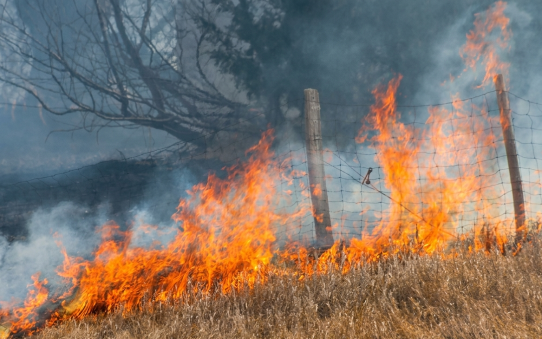
The 2026 Nebraska wildfire complex will generate insurance claims, wrongful death lawsuits, utility negligence actions, and subrogation disputes for years. Unfortunately, the fire was fatal. One died while trying to escape the Morrill Fire. More than 35,000 cattle grazed on land now burned. An estimated 175 structures have been threatened by the Morrill Fire alone. Up to 350,000 acres burned within a single 18-hour period at the peak of the event.
When these cases reach litigation, the central question will be: What were the exact weather conditions at the loss location, at the loss time?
That question cannot be answered by a weather app, a news broadcast, or a regional forecast. It requires forensic weather reconstruction: the systematic retrieval, quality-control, and analysis of archived meteorological data for a specific time and place. This is what a forensic meteorology expert does.
This article walks through the weather evidence, the data sources, and the litigation scenarios that attorneys and claims professionals should understand now, while evidence is still fresh.
The Weather That Built the 2026 Nebraska Firestorm
Three atmospheric ingredients combined to produce extreme fire behavior across the Nebraska Sandhills and western plains: wind, drought, and heat. None alone would have been sufficient. Together, they overwhelmed containment efforts for days.
Wind: The Primary Driver
NWS data documented wind gusts reaching 61 mph across western Nebraska on 2026-03-15, creating firestorm conditions according to NBC News. On Red Flag Warning days, sustained gusts of 45–50 mph were common. The Morrill Fire traveled more than 65 miles in roughly six hours after ignition, according to Watch Duty tracking data cited by Nebraska Public Media.
Wind drove every aspect of fire behavior. Embers traveled hundreds of yards ahead of the fire front. Firefighters described spot fires igniting well beyond containment lines. Wind shifts, from southwest to southeast on one day, then to north overnight, repeatedly changed the fire’s direction. On 2026-03-18, gusty winds caused unburned vegetation within the Morrill Fire’s perimeter to ignite and burn actively on the eastern and southeastern sides in Divisions HH and KK. Blowing dust, smoke, and ash severely restricted visibility for crews, but all flareups were extinguished and the perimeter held.
For litigation, wind evidence comes from ASOS/AWOS stations that record 2-minute sustained wind and 5-second peak gusts every minute. A meteorologist expert witness retrieves METAR and special observations (SPECIs) for the event window and documents wind speed, direction, and timing at each station relevant to the loss location. When the nearest station is more than 10 miles away (common in the Sandhills) the expert applies friction factors, pressure gradient analysis, and multi-station interpolation to estimate conditions at the specific site.
Drought: The Fuel Condition
The U.S. Drought Monitor classified much of western Nebraska as D2 (Severe) to D3 (Extreme) drought at the time the fires started. Below-average snowfall through winter 2025–2026 left rangeland vegetation desiccated. Dormant prairie grass and stands of eastern red cedar, both highly flammable in dry conditions, provided continuous fuel across hundreds of thousands of acres with no natural firebreaks.
Drought data matters in litigation because it establishes foreseeability. If an area carries severe drought classification for weeks, a party that ignites a fire, whether intentionally (prescribed burn) or through negligence (electrical fault), faces stronger arguments that the risk was known and preventable. The Road 203 Fire originated from a federal prescribed burn conducted on 2026-03-10 in the Nebraska National Forest. Residual heat reignited under deteriorating conditions and was reported as wildfire on 2026-03-12. That sequence raises questions about whether burn conditions and post-burn monitoring protocols were adequate given the drought status.
Heat and Humidity: The Atmosphere’s Contribution
Temperatures reached the low 80s °F across western Nebraska during the event, running 15–20 °F above normal for mid-March. NWS North Platte forecast highs in the 80s to low 90s through Saturday, March 22, with potential record-setting heat for the month. Relative humidity dropped as low as 11% on some days and remained in the 15–25% range throughout the event.
The NWS North Platte and Cheyenne Weather Forecast Offices issued Red Flag Warnings repeatedly from 2026-03-12 through at least 2026-03-19. The Red Flag Warning on 2026-03-18 ran from 11:00 a.m. MDT to 7:00 p.m. MDT. A cold front expected Sunday, March 23, may bring cooler temperatures (50s–60s °F) and breezy north winds, marking the first significant weather change since the fires began.
In fire weather science, relative humidity below 15% combined with winds above 25 mph sustained creates critical fire weather conditions. A forensic weather consultant documents these indices from archived surface observations, upper-air soundings, and NWS fire weather products.
Fire-by-Fire Breakdown: What the Record Shows
Morrill Fire: Largest in Nebraska History
Size: 643,361 acres. Containment: 16% per Rocky Mountain CIMT 1 situation report, 2026-03-18. (Note: Containment figures are changing rapidly; some media sources reported higher figures based on different reporting windows.) Personnel: 228. Cause: Officially undetermined per CIMT 1. Gov. Pillen stated a power pole fell near County Roads 108 & 117 near Angora due to gusty winds on 2026-03-12 evening. Counties: Morrill, Garden, Arthur, Keith, Grant. Fatality: Rose White, 86, of Arthur. Structures threatened: ~175 directly; ~500 along perimeter. Agricultural impact: Grazing land for an estimated 35,000 cattle. Nebraska Dept. of Agriculture Director Sherry Vinton confirmed the acreage figure.
Mapping note: The 71,277-acre increase reported on 2026-03-18 was not new fire growth. Rocky Mountain CIMT 1 spokesman Rob Powell confirmed the jump resulted from a mapping flight, the first since Sunday evening, that provided more accurate perimeter data, filling in areas previously unmapped.
Cottonwood Fire
Size: 128,036–131,259 acres (depending on report timing). Containment: 78% (as of March 19). Personnel: 172. Cause: Undetermined. Counties: Dawson, Lincoln, Frontier. Location: South of I-80, near Brady and Gothenburg. Ignited near Cottonwood Road southeast of Maxwell. Structures threatened: ~170. Evacuations issued for Jeffrey Lake area (Level 3, “Go”). National Guard Blackhawk helicopters made bucket drops around Jeffrey Lake where thick stands of red cedar held heat. On 2026-03-18, strong winds drove fire activity for approximately two hours in the southeastern half, but containment lines held.
Road 203 Fire
Size: 35,912 acres. Containment: 76%. Cause: Attributed to a federal prescribed burn conducted on 2026-03-10 in the Nebraska National Forest. Residual heat from the burn reignited under deteriorating fire weather conditions and was reported as the Road 203 Fire on 2026-03-12. Counties: Thomas, Blaine. Location: Within and near the Nebraska National Forest, south of Halsey and Dunning. With decreased fire activity, a smaller management team began overseeing the fire as of 2026-03-19.
Anderson Bridge Fire
Size: 16,182–17,400 acres (16,182 per Cherry County Emergency Management aerial mapping; 17,400 per NIFC). Containment: 60%. Location: Off Anderson Bridge Road, north of the Niobrara River, south of Kilgore, Cherry County. Fire started approximately 9 miles south of Kilgore near the Niobrara River Valley at approximately 4:40 p.m. on 2026-03-13. Preliminary cause: snapped power pole due to wind. Wind gusts over 60 mph pushed the fire approximately 15 miles east to Highway 97 before a wind shift turned it south.
Data Sources for Nebraska Wildfire Reconstruction
Forensic fire weather reconstruction draws on multiple independent data sources. Each serves a different purpose. Each has limitations. A qualified forensic meteorology expert uses all of them together and documents which ones agree and which ones conflict.
NOAA ASOS/AWOS Surface Stations
ASOS stations at airports like KBFF (Scottsbluff), KLBF (North Platte), and KSNY (Sidney) provide the primary wind, temperature, humidity, and visibility record for the western Nebraska fire zone. Additional ASOS and AWOS stations in the broader region supplement coverage. These stations record minute-by-minute data and produce hourly METAR observations plus SPECIs when conditions change rapidly.
Limitation: Station density is low across the Sandhills. The nearest ASOS may be 30–50 miles from a loss location. Interpolation is required, and representativeness must be documented.
RAWS (Remote Automated Weather Stations)
RAWS stations in fire-prone areas measure wind, humidity, temperature, fuel moisture, and precipitation. Data is archived through the Western Regional Climate Center (WRCC) and NOAA. Western Nebraska has RAWS coverage in National Forest and grassland areas.
Limitation: RAWS stations can be damaged or destroyed by fire. If a station was overrun, its data record may end before the event peak. This gap must be documented.
NEXRAD Radar, Satellite, and Incident Command Records
NEXRAD WSR-88D radar from KLNX (North Platte) and KCYS (Cheyenne) detects pyrocumulus clouds and smoke plumes. GOES-18 (West) and GOES-19 (East) satellite imagery provides thermal hotspot detection and smoke extent. Rocky Mountain CIMT 1 situation reports, mapping flight data, and division-level logs document fire perimeter changes and crew actions. These incident records corroborate weather observations and establish the timeline attorneys need.
Limitation: Radar beam height increases with distance. At 100 miles from KLNX, the beam samples well above surface level. UAS mapping flights, like the one that corrected the Morrill Fire acreage on 2026-03-18, provide ground truth but are weather-dependent.
NCEI Archives and SPC Products
NOAA National Centers for Environmental Information (NCEI) maintains the official U.S. weather archive. The Storm Prediction Center (SPC) issues Fire Weather Outlooks that document the official risk assessment for each day.
Forensic value: SPC outlooks establish foreseeability. If SPC issued a Critical fire weather outlook on the day a prescribed burn was conducted or a utility line failed, that fact is directly relevant to negligence claims.
Litigation Scenarios Emerging from the 2026 Nebraska Fires
Each case type requires different weather evidence. A weather litigation expert tailors the analysis to the specific legal question.
Utility Negligence and Ignition Liability
Gov. Pillen stated a power pole fell near County Roads 108 & 117 near Angora due to gusty winds on 2026-03-12, sparking what became the Morrill Fire. The Rocky Mountain CIMT 1 lists the official cause as undetermined. If utility infrastructure failed under wind loads, the critical question is: did the actual wind speed exceed the design standard for the equipment? A meteorologist expert witness documents the precise wind conditions, both sustained and gust, at the ignition point and time. The National Electrical Safety Code (NESC/ANSI C2), which governs utility pole and line design wind loads, utility maintenance records, and NERC reliability standards all come into play.
Regional note: Utility negligence wildfire litigation is well-established in California and Texas. Nebraska cases will follow similar frameworks, but Great Plains spring wind climatology, particularly the frequency of 50+ mph gusts, differs from Gulf Coast or Mountain West wind regimes and may affect foreseeability arguments.
Prescribed Burn Liability (Road 203 Fire)
The Road 203 Fire originated from a federal prescribed burn conducted on 2026-03-10 in the Nebraska National Forest. Residual heat from the burn reignited under worsening fire weather conditions and was reported as the Road 203 Fire on 2026-03-12. A forensic meteorology expert reconstructs the weather conditions at the time of the original burn, during the interim period, and at reignition. Were the original burn conditions within prescribed parameters? Did wind, humidity, or drought conditions change between the burn and reignition? Was the burn site properly monitored during the two-day interim?
Prescribed burn negligence cases turn on the gap between forecast conditions and actual conditions at the burn site. RAWS data, SPC fire weather outlooks, and NWS spot forecasts requested by burn managers are all discoverable evidence.
Insurance Claims and Subrogation
Property damage claims will involve structures, fencing, livestock, equipment, and rangeland. Insurers must determine whether fire, smoke, wind, or a combination caused each loss. Anti-concurrent causation (ACC) clauses complicate coverage when multiple perils contribute. A climate expert witness provides the weather timeline that separates wind damage from fire damage from smoke damage.
Subrogation claims against the responsible ignition party require proving causation from the ignition source through the weather conditions to the specific loss. Weather reconstruction provides the middle link in that chain.
Wrongful Death
Rose White, 86, of Arthur, Nebraska died while attempting to escape the Morrill Fire. Wrongful death litigation may examine whether evacuation warnings were timely, whether the fire’s rate of spread was foreseeable given the weather conditions, and whether the wind-driven advance exceeded what a reasonable person could escape. The fire traveled more than 65 miles in roughly six hours after ignition, according to Watch Duty data cited by Nebraska Public Media. A forensic weather consultant reconstructs minute-by-minute wind speed, fire weather conditions, and atmospheric stability at the time and location of the death.
Limitations of Fire Weather Evidence
No forensic analysis is perfect. Attorneys must understand the limitations a meteorologist expert witness will acknowledge, and opposing counsel will exploit.
Station density: Western Nebraska has fewer surface weather stations per square mile than urban areas. The nearest ASOS may be 30–50 miles from a loss location. Interpolation introduces uncertainty. A credible expert quantifies that uncertainty rather than ignoring it.
Microclimate effects: The Sandhills’ rolling topography creates variable wind exposure. Flat-terrain wind estimates may understate ridgetop conditions. River valleys and canyons channel wind locally.
Fire-generated weather: Large fires create their own wind patterns. Pyroconvection produces erratic gusts and direction shifts that surface stations, often miles away, do not capture. The dust, smoke, and ash that restricted visibility on 2026-03-18 are products of fire-atmosphere interaction.
Mapping lag: As the Morrill Fire demonstrated, acreage figures can jump dramatically when new mapping flights occur. The 71,277-acre increase on 2026-03-18 was not fire growth. It was better measurement. Attorneys should verify whether acreage claims are based on ground-truthed perimeters or estimated figures.
Cost of Hiring a Meteorologist Expert Witness for Wildfire Cases
Forensic meteorology expert witness fees vary by case complexity and scope:
Initial case review: Many forensic meteorologists offer a free or low-cost initial consultation to determine whether weather evidence supports the claim.
Analysis and report preparation: $200–$500 per hour. A standard fire weather reconstruction report requires 10–30 hours depending on the number of loss locations and the complexity of the event timeline.
Deposition and trial testimony: $2,000–$7,500 per day. Travel and preparation billed separately.
The cost is a fraction of the value at stake. The Morrill Fire alone affected grazing land supporting an estimated 35,000 cattle. Individual property claims from wildfire events routinely reach six and seven figures. Subrogation recoveries against negligent parties depend on proving the weather-to-damage causal chain, which is exactly what weather expert witness services provide.
Frequently Asked Questions About Wildfire Weather Evidence
What weather data matters most in Nebraska wildfire litigation?
ASOS/AWOS surface observations (wind speed, relative humidity, temperature), NEXRAD radar for convective activity, RAWS stations for fire weather zones, and NCEI archived records form the primary evidence base. A forensic meteorology expert cross-references these sources to establish wind direction, gust intensity, and humidity at specific times and locations relevant to the claim.
How much does a meteorologist expert witness cost for a wildfire case?
Forensic meteorology expert witness fees typically range from $200 to $500 per hour for analysis and report preparation. Testimony fees run $2,000 to $7,500 per day depending on case complexity, travel, and whether the engagement involves deposition or trial.
Can a forensic meteorologist prove what caused a wildfire to spread?
A certified meteorologist witness can reconstruct wind speed, direction, humidity, and temperature at the time and location of fire spread. This reconstruction establishes whether atmospheric conditions drove the fire’s behavior and rate of spread. The analysis does not determine ignition cause but documents the weather conditions that governed how the fire moved.
What is the difference between fire weather forecasting and forensic fire weather reconstruction?
Fire weather forecasting predicts future conditions using models. Forensic fire weather reconstruction analyzes what already happened using archived observations, radar data, and mesonet records. Reconstruction provides court-admissible evidence tied to specific times and locations. Litigation requires the backward-looking analysis that a forensic meteorology expert performs.
How does drought status affect wildfire insurance claims in Nebraska?
The U.S. Drought Monitor classification at the time of a fire directly affects causation arguments. If an area carried D2 (Severe) or D3 (Extreme) drought status, defense teams may argue conditions were foreseeable and mitigation was required. A weather litigation expert documents the official drought classification, precipitation deficits, and soil moisture data for the claim period.
What qualifications should a wildfire meteorologist expert witness have?
Look for a B.S. or higher in meteorology or atmospheric science, American Meteorological Society (AMS) certification, National Weather Association (NWA) credentials, and documented litigation experience including Daubert or Frye qualifications. Experience with NOAA data systems, NEXRAD radar interpretation, and fire weather indices strengthens testimony.
Key Takeaways
The 2026 Nebraska wildfire complex is generating litigation across utility negligence, prescribed burn liability, insurance coverage disputes, subrogation, and wrongful death. Three facts control every case:
- NWS-documented wind gusts reached 61 mph, relative humidity dropped as low as 11%, and temperatures ran 15–20 °F above normal for mid-March. The Morrill Fire traveled 65 miles in roughly six hours after ignition. Forensic reconstruction of wind, humidity, and temperature at each loss location and time is the foundation of every claim.
- Station density is thin across western Nebraska. The quality of the expert’s interpolation methodology and uncertainty documentation will determine whether the analysis survives Daubert or Frye challenges.
- Evidence preservation starts now. RAWS stations may have been destroyed. Spot forecasts, prescribed burn permits, utility maintenance logs, and CIMT situation reports are all discoverable. Engaging a forensic meteorology expert early ensures the weather data is retrieved, quality-controlled, and documented before records age or become harder to access.
Technical Appendix: Methods, Datasets, and Quality Control
Primary Datasets:
NOAA ASOS stations: KBFF (Scottsbluff), KLBF (North Platte), KSNY (Sidney). AWOS stations in affected counties as available. RAWS stations via WRCC/NIFC archives. NCEI Integrated Surface Database (ISD) for quality-controlled hourly and sub-hourly records. U.S. Drought Monitor weekly classifications. SPC Fire Weather Outlooks (Day 1–3) for 2026-03-10 through present. NEXRAD Level-II data from KLNX (North Platte) and KCYS (Cheyenne). GOES-18 (West) and GOES-19 (East) satellite visible and infrared imagery. Rocky Mountain CIMT 1 situation reports and mapping flight data.
QC Steps:
All ASOS/AWOS observations checked against NCEI quality flags. Observations flagged as erroneous, estimated, or suspect annotated and excluded from primary analysis. Multi-station consistency checks applied. Sensor maintenance logs reviewed where available. RAWS data cross-checked against nearest ASOS for consistency.
Uncertainty Quantification:
Wind speed at locations between stations: ± 5–15 mph depending on distance and terrain. Humidity: ± 3–5% RH. Temperature: ± 2–4 °F. Confidence assigned per three-tier system: High (2+ independent sources agree within expected tolerance), Medium (partial agreement or minor siting concerns), Low (sparse or conflicting data, model reliance for key numbers).
Reanalysis Corroboration:
HRRR (3 km grid spacing, hourly) and RAP (13 km) model analyses used as corroboration only, not primary evidence. Model output conflicting with observations is noted and explained.
Chain of Custody
Data retrieval date: 2026-03-19 (ongoing event; data will be updated as fires reach full containment).
Sources queried: NCEI ISD via Climate Data Online; Iowa Environmental Mesonet ASOS/AWOS archives; WRCC RAWS database; SPC archived fire weather outlooks; NWS North Platte and Cheyenne WFO products; U.S. Drought Monitor; NIFC InciWeb incident reports; Rocky Mountain CIMT 1 situation reports via NRDnet and InciWeb; Nebraska Emergency Management Agency briefings.
Tools: Standard meteorological analysis software; NCEI data retrieval tools; NWS RIDGE radar viewer; GIS mapping for station location and terrain analysis.
Uncertainty note: This event is ongoing as of publication. Final containment figures, official cause determinations, and complete post-fire damage assessments are pending. Figures cited reflect the best available information as of 2026-03-19 and should be verified against official records as they are finalized. The Morrill Fire cause remains officially undetermined per Rocky Mountain CIMT 1 despite Gov. Pillen’s statements attributing it to an electrical issue.
About the Author
John Bryant is a distinguished forensic meteorologist with 30+ years of specialized experience in weather analysis and reconstruction, as well as expert witness testimony. He holds the rare global distinction of triple certification by the American Meteorological Society (AMS), the National Weather Association (NWA), and the Environmental Protection Agency (EPA). He is recognized as one of the few meteorologists worldwide to hold all three certifications concurrently. Mr. Bryant provides authoritative expert testimony and forensic weather reconstruction for high-stakes litigation on behalf of both defense and plaintiff. He holds a B.S. in Geosciences with an emphasis in Meteorology and Atmospheric Science from Mississippi State University and previously served as Chief Meteorologist at an ABC affiliate station in Memphis for over a decade.
Need Expert Weather Analysis for Your Case?
Use the contact form below or email me for a free case review.
Forensic Meteorology Resources
Weather Data & Research:
- National Oceanic and Atmospheric Administration (NOAA)
- National Weather Service
- National Centers for Environmental Information
The author of this article is not an attorney. This content is meant as a resource for understanding forensic meteorology. For legal matters, contact a qualified attorney.