As Hurricane Milton barrels toward the Florida coastline, the latest National Hurricane Center (NHC) updates confirm the storm’s staggering intensity and potential for widespread devastation. Milton has undergone an eyewall replacement, which can temporarily weaken a storm. However, Hurricane Milton has rebounded quickly, now packing winds of 150 mph with a minimum central pressure of 929 mb—a clear signal that this storm is not slowing down.
Milton’s eyewall contraction, now at just 12 nautical miles in diameter, indicates a compact yet ferocious storm with the potential to cause massive destruction. With landfall expected on the west-central coast of Florida by Wednesday night, Milton has the potential to be one of the most powerful hurricanes ever to strike this region.
What to Expect from Hurricane Milton
As of the latest update, Milton remains an extremely dangerous Category 4 hurricane, and there is no sign of significant weakening before it reaches the Florida coastline. Milton’s destructive potential remains extremely high despite the possibility of vertical wind shear and the beginning of its extratropical transition. The hurricane is forecasted to bring life-threatening conditions far beyond its immediate path.
Track and Intensity Update
Milton is currently moving east-northeast at around 8 knots, but it is expected to turn more to the northeast and speed up as it interacts with an incoming trough in the Gulf of Mexico. The projected track places landfall somewhere along Florida’s west-central coast, but residents should remain alert for any last-minute wobbles or shifts. While forecasts predict a landfall late Wednesday night, uncertainty remains about the exact location, and the NHC warns that the track could still deviate by as much as 60-70 nautical miles.
Expanding Wind Field
Another alarming factor is Milton’s expanding wind field. The area affected by hurricane and tropical-storm-force winds is expected to roughly double by landfall, meaning that this storm’s impacts will stretch far beyond the immediate path of its eye. Even communities outside the forecast cone should prepare for dangerous conditions, with hurricane-force winds and storm surge extending well into the surrounding regions.
Major Threats to Florida
Storm Surge
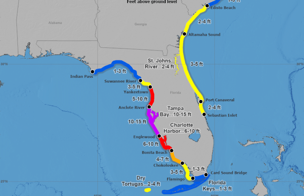
The impending storm surge may be the most significant immediate concern for Florida’s Gulf Coast. Milton is expected to bring a catastrophic surge to parts of the west-central coast, with inundations potentially exceeding 10 feet in some areas. This surge and destructive waves pose a life-threatening hazard to coastal residents. If you are in a storm surge warning area, it is critical to evacuate immediately. The safe evacuation window will close tonight, and waiting until Wednesday may be too late.
Damaging Winds
Hurricane Milton’s intense winds will begin lashing Florida by late Tuesday or early Wednesday. Residents along the coast can expect sustained winds nearing 125 mph at landfall, which is more than capable of causing catastrophic damage to buildings, infrastructure, and power lines. These winds will not only affect coastal areas but will also extend well inland across the Florida Peninsula. Long-duration power outages are highly likely, and preparations to protect life and property should be completed as soon as possible.
Heavy Rainfall and Flooding
In addition to the dangerous winds and storm surge, Milton is expected to dump significant amounts of rain across Florida, leading to widespread flooding. Rainfall totals could exceed 10 inches in some locations, bringing a risk of flash flooding, particularly in urban areas. River flooding is also a significant concern as heavy rainfall combines with the effects of coastal storm surge.
Urgent Preparations and Safety Tips
With landfall just 36-48 hours away, it is time for Florida’s west coast residents to complete their storm preparations. Follow these key safety steps:
1. Evacuate if Ordered: If local officials have issued evacuation orders for your area, do not hesitate. The threat of storm surge and flooding is exceptionally high, and waiting until the storm arrives could put you in significant danger.
2. Secure Your Property: Bring outdoor furniture, secure windows and doors with shutters, and clear debris from yards that could become projectiles in high winds.
3. Prepare for Power Outages: Stock up on essentials like water, non-perishable food, batteries, and medications. Ensure you have a safe way to stay informed about updates from local officials if power and internet services go down.
4. Avoid Floodwaters: Flash flooding can occur with little warning. Avoid driving through flooded streets and stay on higher ground. Water levels can rise quickly, and even shallow floodwaters can be deadly.
Looking Ahead
As Hurricane Milton nears the Florida coastline, the storm is expected to maintain its strength, even as it interacts with stronger vertical wind shear and transitions to an extratropical system. After landfall, Milton will track across Florida and emerge over the Atlantic by Thursday. Even after moving inland, damaging winds, heavy rainfall, and flooding will continue to affect large parts of the state.
The National Hurricane Center will continue to provide frequent updates, and I will keep you informed as new data becomes available. Stay safe and follow all instructions from local emergency management officials.
Key Takeaways
1. Extremely Dangerous Winds: Sustained winds of 125 mph are expected to cause catastrophic damage along Florida’s west coast.
2. Life-Threatening Storm Surge: Surge levels of over 10 feet in some areas will result in significant coastal flooding. Evacuate if ordered.
3. Heavy Rainfall and Flooding: Expect flash flooding in urban areas and along rivers, with combined threats of coastal and inland flooding increasing the overall risk.
Now is the time to act. Make sure your preparations are complete and stay informed.