This Storm System Has Unique Characteristics and Threats
Weather Alert: Memphis, the Mid-South, and numerous other states are facing a serious storm threat tomorrow. Here’s what you need to know to stay safe.
Why This Storm Is Different
This isn’t our average thunderstorm. Friday’s weather system brings several unique dangers:
- Nighttime storms when most people are sleeping – making it harder to stay aware of warnings
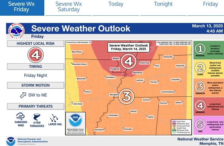
- Extremely powerful winds that could reach 70-90 mph (strong enough to damage homes and buildings)
- Possible tornadoes that could last longer than typical brief touchdowns
- Very large hail (potentially baseball-sized) that can damage cars and homes
- Fast-developing weather system that might intensify more quickly than usual
- It is important to understand that not everyone will be hit, but everyone in the colors is under a threat.
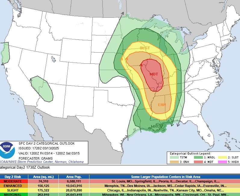
Understanding the Risk Levels for Your Area
The Storm Prediction Center and National Weather Service use a Simple Color System to Show How Dangerous Storms Might be:
What the colors mean:
- Red (Moderate Risk): Highest danger level for this forecast – widespread severe weather expected
- Orange (Enhanced Risk): Significant danger – Memphis is in this zone
- Yellow (Slight Risk): Scattered but still dangerous storms possible
- Dark Green (Marginal Risk): Isolated severe weather
- Light Green: Regular thunderstorms without widespread severe threats
How to Prepare: Simple Steps to Take Today
1. Stay Informed
- Download a reliable weather app with alerts
- Keep your phone charged and nearby
- Have a battery-powered weather radio ready
2. Know Where to Go
- Identify the safest spot in your home (basement is best, or an interior bathroom or closet on the lowest floor)
- Stay away from windows during the storm
- If you live in a mobile home, plan where you’ll go if warnings are issued
3. Prepare Emergency Supplies
- Flashlights and extra batteries
- Bottled water and non-perishable food
- Important medications
- Fully charged power banks for phones
- Essential documents in a waterproof container
4. Create a Family Plan
- Discuss how you’ll contact each other if separated
- Establish a meeting place if you can’t return home
- Make sure everyone knows where to go when warnings are issued
Timeline: When to Expect the Storms in the Mid-South
- Friday Afternoon: Storm system begins developing west of Memphis
- Friday Evening: Storms intensify and move into the Memphis area
- Friday Night through Early Saturday: Highest risk period for dangerous weather
Other Cities at Risk
- Highest Risk (Red): St. Louis, Springfield, Peoria, and other parts of Illinois
- Enhanced Risk (Orange): Memphis, Des Moines, Jackson, Cedar Rapids, Evansville
- Slight Risk (Yellow): Chicago, Indianapolis, Nashville, Kansas City, Omaha
- Marginal Risk (Green): Milwaukee, New Orleans, Minneapolis, Cincinnati, St. Paul
Understanding Weather Warnings
Know the difference between these alerts:
- Watch: Conditions are right for severe weather. Stay alert and have your safety plan ready.
- Warning: Severe weather is happening or imminent. Take action immediately!
After the Storm
- Check on neighbors, especially the elderly or those with special needs
- Watch for downed power lines and report them immediately
- Document any damage with photos for insurance claims
- Listen for updates as additional storms may follow
- Weather-related insurance and storm claims are increasing. If you ever need help from a weather expert, you can click here to get in touch.