Tropical Storm Milton is rapidly strengthening in the Gulf of Mexico, and it’s forecast to become a major hurricane soon. Satellite and aircraft data from the National Hurricane Center (NHC) indicate that Milton has the potential to intensify quickly, posing a serious threat to Florida’s Gulf Coast. With forecasts predicting life-threatening conditions by midweek, residents need to act fast to prepare for what could be a powerful and destructive storm.
Milton’s Rapid Intensification: What You Need to Know
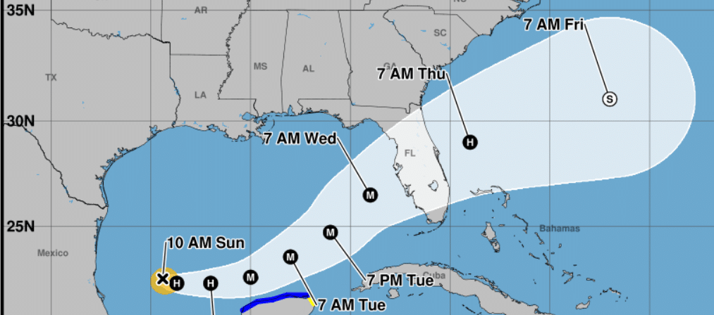
As of the latest NHC advisory, Tropical Storm Milton has winds of 55 knots (about 65 mph) and is moving east southeastward at 105 degrees/5 knots. It is expected to intensify into a hurricane soon, and further strengthening is anticipated over the warm waters of the Gulf of Mexico.
The storm’s path has shifted south of earlier predictions, with a new trajectory aiming toward Florida’s western coast by midweek. NHC forecasts show that Milton could accelerate and turn northeastward toward the Florida Peninsula, likely making landfall around Wednesday. The updated forecast puts areas across Florida’s west coast and parts of the Yucatan Peninsula on high alert.
Milton is expected to produce a dangerous storm surge, particularly along Florida’s Gulf Coast. The low pressure and rapid intensification could lead to widespread flooding, with storm surge heights expected to be extremely dangerous. Maximum sustained winds could reach 125 mph at landfall, causing significant damage to homes, infrastructure, and power lines.
This storm will have huge impacts on Florida and the Gulf Coast.
Rapid Intensification in Progress:
Data from NOAA Hurricane Hunter aircraft show that Milton is intensifying rapidly due to the very warm Gulf waters and low wind shear. The eyewall is already forming, which signals that the storm will likely strengthen into a powerful hurricane. Milton’s pressure has dropped to 991 mb; further drops could mean a stronger storm in the coming days.
Areas Most at Risk:
Florida’s Western coast could see the worst of the storm. Inland areas are also at risk of heavy rainfall and flash flooding. The NHC notes that the track error can be up to 100 miles on day 3, meaning that areas outside the immediate path should still prepare for potential impacts.
Prepare Now:
Residents in Milton’s path should take action immediately:
-Secure outdoor items and make preparations for power outages.
-Evacuation plans should be reviewed and executed if orders are given.
-Stock up on emergency supplies like food, water, batteries, and medications.
-Stay tuned to local weather alerts for updates on evacuation zones.
Why is Milton Gaining Strength So Fast?
The hot waters of the Gulf, coupled with little wind shear, are perfect conditions for rapid intensification. According to the NHC, Milton could become a major hurricane (Category 3 or higher) before landfall. Given the storm’s quick progression, coastal residents have less time to prepare.
Hurricane Milton is shaping up to be a dangerous and rapidly intensifying storm, with life threatening impacts expected along Florida’s Gulf Coast. The NHC’s latest forecasts illustrate the urgency for residents to finalize preparations and follow evacuation orders. The storm’s intensity, fueled by warm Gulf waters, will likely increase significantly in the coming days, making it crucial to act now to ensure your family’s and property’s safety.