How Ocean Maps Help Forecast Hurricanes and Protect Communities (Updated for June 2025)
Written by John Bryant June 16th, 2025
Predicting hurricanes isn’t just about watching a storm on radar. It starts long before a system forms. Ocean maps give meteorologists early clues about how a hurricane might develop, how strong it could become, and where it might go. When used correctly, these maps can save lives and limit damage.
I love explaining what these ocean maps are, why they matter, and how they help experts like me give you accurate warnings.
What Is an Ocean Map?
An ocean map in meteorology is a tool that shows current weather and ocean conditions. These include:
- Wind speed and direction
- Relative humidity
- Sea surface temperatures
- Ocean currents
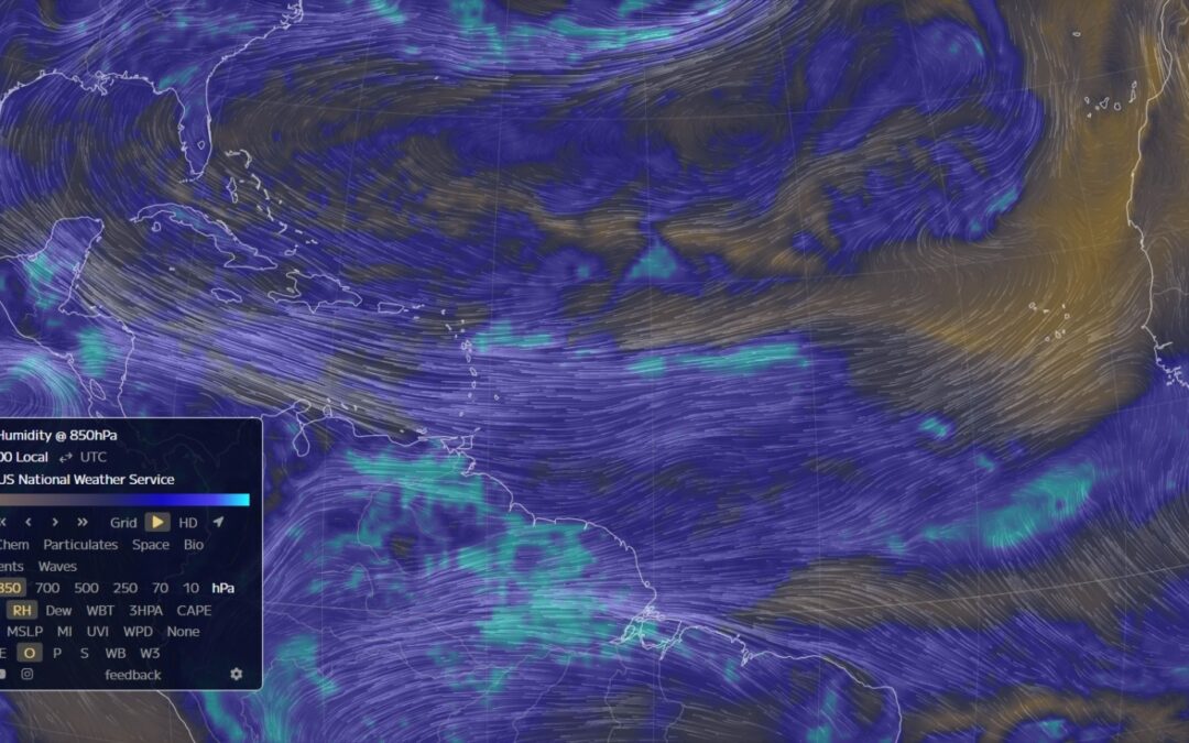
One of the most useful layers for hurricane forecasting is the 850mb level, which sits about 5,000 feet above sea level. It helps forecasters see how moist the air is and how winds are flowing in the lower part of the atmosphere.
This map helps us track tropical waves and early signs of storm formation. For example, if the air is humid and winds are rotating in a specific pattern, it can mean that a tropical system is trying to organize.
Why Ocean Maps Matter in Hurricane Forecasting
Hurricanes need three key ingredients:
- Warm ocean water
- Moist air
- Light upper-level wind shear
Ocean maps help forecasters see if all of these ingredients are present. By watching trends in sea surface temperature, wind patterns, and moisture, meteorologists can forecast not just where a storm is heading, but how strong it might become.
We can also use these maps to identify threats like dry air or Saharan dust that could weaken a storm before it reaches land. This kind of forecasting is not guesswork. It’s based on interpreting clear, observable signals in the atmosphere.
Why You Should Care
If you live anywhere near a coastline, understanding ocean maps can give you a real edge. Here’s why:
- It gives you more time to prepare your home or evacuate if needed
- It helps you understand forecast updates better
- It allows you to make smart decisions for your business, especially if you rely on shipping, logistics, or tourism
The more you understand what the forecasters are seeing, the better you can respond.
Expert Insight From 27 Years in the Field
Over the past three decades, I’ve helped clients from homeowners to Insurance companies prepare for major storms. I’ve worked on legal cases where understanding the 850mb humidity and wind flow made the difference in proving whether a storm had the potential to intensify or not.
Ocean maps are not just pretty visuals. They are trusted, science-backed resources. And when interpreted correctly, they can give you a clearer picture of what’s coming.
What You Can Do Now
Here are three simple things you can start doing today:
- Follow a trusted meteorologist or weather service online
- Bookmark real-time ocean maps like earth.nullschool.net
- Learn how to spot high moisture areas and rotating wind patterns
Even a basic understanding of what these signals mean can help you stay ahead of the storm.
Recap: What to Remember
- Ocean maps track wind, moisture, and temperature patterns that can signal storm development
- The 850mb layer is especially useful for identifying early signs of hurricane formation
- Understanding these maps improves your ability to react quickly and effectively
- You don’t need a degree in meteorology to learn the basics
If you’re facing a storm-related legal issue, insurance claim, or business decision, this knowledge matters. And if you need a second opinion or expert analysis, I’m available for consultations. Feel free to reach out to me here. Contact a Weather Expert
You can learn more about the types of SERVICES an expert can help you with.
Let’s work together to stay informed, stay safe, and stay prepared.
Visit http://www.weatherandclimateexpert.com to learn more about how expert forecasting can support you when it matters most.
Want to help others stay informed? Share this article with friends or family that live in hurricane-risk zones.
Also, visit The National Hurricane Center and their website and bookmark it to use throughout this hurricane season.