Finding a Sun Glare Accident Meteorologist Expert Witness Can Be Tricky; Here’s What You Need to Know
Most sun glare experts use solar calculators and Google Maps to analyze crashes from their desks. That approach misses 5 critical factors that determine whether a driver was actually blinded: local obstructions (trees, buildings, signs), roadway elevation changes (cut/fill slopes alter sun angle by 3-15 degrees), reflective surfaces (glass, wet pavement, vehicle mirrors), atmospheric conditions (fog, haze, pollution reduce glare by 40-70%), and the lack of demonstrative evidence that juries can understand. A qualified forensic meteorologist conducts site visits at the same time of day to document real-world conditions, measures actual sun angles from the driver’s perspective, photographs obstructions and reflective surfaces, and creates evidence that survives cross-examination. Desk analysis fails in court because it cannot account for these location-specific variables.
| Scope | United States — nationwide motor vehicle crashes |
|---|---|
| Critical Variables | Solar azimuth/altitude, roadway heading, obstructions, elevation, atmospheric transmission |
| Site Visit Timing | Same clock time ± 15 minutes, within ± 30 days of the incident date (seasonal variation) |
| Data Sources | NOAA Solar Position Calculator, USGS elevation data, NWS METAR/visibility reports, crash scene photos |
| Key Measurements | Solar altitude 5-20° (peak glare zone), roadway heading ± 30° of solar azimuth, visibility ≥ 5 statute miles |
| Confidence | High (with site visit + contemporaneous weather); Low (desk analysis only) |
Why Desk Analysis Fails in Sun Glare Cases
Solar position calculators provide accurate astronomy. They tell you where the sun was in the sky at any given moment. But they cannot tell you what the driver actually saw. Between the theoretical sun position and the driver’s retina lie five physical variables that desk analysis misses entirely.
Courts require forensic meteorologists to demonstrate causation, not just possibility. Proving that the sun was at 12 degrees above the horizon does not prove the driver was blinded. You must account for local conditions that either create or eliminate glare exposure.
The Five Critical Factors Desktop Analysis Cannot Detect
1. Local Obstructions Block the Sun’s Direct Path
The problem: GPS coordinates and solar calculators assume a clear line of sight from the driver to the sun. Real-world intersections have buildings, trees, overhead signs, utility poles, and elevated roadways that block direct sunlight.
Real-world example: Your expert calculates that the sun was directly in the driver’s line of sight at 7:42 AM. You present this at trial. Opposing counsel produces a photograph showing a 40-foot billboard that completely blocks the sun from that driver’s position. Your case collapses.
Why this matters: A driver cannot be blinded by a sun they cannot see. You must document every obstruction between the driver’s eye position and the solar disc. Google Street View is outdated and shows incorrect tree canopy density. Buildings get constructed. Signs get installed.
What qualified experts do: They visit the location. They stand where the driver stood. They photograph the view at the same time of day, within 30 days of the incident anniversary. They measure obstruction heights and distances. They document seasonal foliage changes in deciduous tree zones (Northeast, Midwest, Pacific Northwest versus desert Southwest).
2. Cut and Fill Slopes Change the Effective Sun Angle
The problem: Solar calculators compute sun altitude relative to a horizontal plane. But roadways are rarely horizontal. Interstate highways cut through hillsides (cut slope) or are built up above grade (fill slope). A road tilted 6 degrees down changes the effective sun angle by 6 degrees.
Real-world example: Your calculations show the sun at 18 degrees altitude—above the typical 5-15 degree glare zone. But the roadway descends at a 5-degree grade into the intersection. The effective sun angle from the driver’s tilted reference frame is 13 degrees. The driver was in the peak glare zone. Your desk analysis missed it.
Why this matters: The same sun position creates different glare exposure depending on roadway grade. Downhill grades increase glare risk. Uphill grades reduce it. This is especially critical in mountainous terrain (Appalachians, Rockies, Sierra Nevada) and highway interchanges with elevation changes.
What qualified experts do: They obtain survey-grade elevation data from highway plans or USGS digital elevation models. They measure roadway grade with inclinometers. They photograph the approach showing the visible grade change. They calculate the sun’s altitude in the driver’s tilted reference frame, not just the horizontal reference frame.
3. Reflective Surfaces Create Secondary Glare Sources
The problem: Drivers are not only blinded by direct sunlight. Reflected glare from glass buildings, wet pavement, vehicle windshields, and metal signs can be as intense as direct sun. Solar calculators only compute the sun’s position. They do not identify reflective surfaces that redirect sunlight into the driver’s eyes.
Real-world example: The sun was 45 degrees to the left of the driver’s heading—no direct glare. But a glass-facade office building to the driver’s right reflected sunlight directly into the vehicle. The driver was blinded by reflected glare, not direct glare. Desk analysis would have concluded that no glare exposure existed.
Why this matters: Reflected glare is unpredictable. It depends on building materials, vehicle positions, and pavement moisture. It changes with weather conditions. Rain creates mirror-like pavement. Snow cover increases albedo. Fog droplets scatter light omnidirectionally.
What qualified experts do: They photograph all reflective surfaces within 300 feet of the driver’s position. They document glass buildings, polished metal signs, wet pavement, and puddles. They analyze reflective angles using the law of reflection (angle of incidence equals angle of reflection). They test whether reflected sunlight could reach the driver’s eye position.
4. Atmospheric Conditions Reduce or Eliminate Glare Intensity
The problem: Solar calculators assume a clear atmosphere. Real atmospheres contain fog, haze, smoke, and pollution that scatter and absorb sunlight. Visibility below 5 statute miles reduces solar intensity by 40-70%. Heavy fog eliminates glare entirely.
Real-world example: Your expert testifies that the sun was in perfect glare position at 7:15 AM. The defense produces a METAR from the nearest airport showing visibility of 2 statute miles in fog at 7:00 AM. The sun was completely obscured. Your glare theory is destroyed.
Why this matters: Glare requires direct or near-direct sunlight. Fog, clouds, and haze prevent glare by scattering light before it reaches the driver. You cannot assume clear conditions. You must verify atmospheric transparency using contemporaneous weather observations. Regional differences matter: coastal fog (California, Pacific Northwest), lake-effect haze (Great Lakes), wildfire smoke (western states in summer), and industrial pollution (urban corridors).
What qualified experts do: They obtain METAR observations from the nearest NWS airport station within 30 minutes of crash time. They document cloud cover, visibility, and present weather. They retrieve ASOS/AWOS 1-minute data when available. They analyze satellite imagery (GOES-16/17 visible channels) to verify cloud cover. They account for microscale fog in river valleys or near bodies of water that airport stations may not capture.
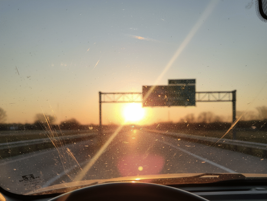
5. Demonstrative Evidence Makes Technical Analysis Understandable to Juries
The problem: Juries do not understand solar azimuth charts, trigonometric calculations, or NOAA algorithm outputs. Expert testimony filled with technical jargon loses jury attention. You need visual evidence that instantly communicates the driver’s experience.
Real-world comparison: You are trying to convince someone that a cake is delicious. You have two options. Option A: Hand them a recipe printout with measurements and baking times. Option B: Bring them an actual slice to taste. Site inspection is Option B.
Why this matters: Photographs from the driver’s seat showing the sun dead-center in the windshield are irrefutable. Opposing counsel can attack your calculations. They cannot attack photographic reality. Courts favor demonstrative evidence over abstract testimony.
What qualified experts do: They photograph the view from the driver’s position at the same time of day, one year after the crash (solar position repeats annually within minutes). They create video recordings driving the approach to show glare duration and intensity. They document the sun’s position relative to traffic signals, road signs, and the point of impact. They produce annotated images with overlays showing solar azimuth and altitude. They provide exhibits that jurors can immediately understand without technical translation.
How to Verify Expert Qualifications
Not all meteorologists understand forensic glare analysis. You need specific qualifications and demonstrated experience in crash reconstruction applications.
Required Technical Background
Your expert must demonstrate competency in atmospheric optics, solar geometry, and photometry. They should hold a degree in meteorology, atmospheric science, or physics. Professional certification from the American Meteorological Society (AMS Certified Consulting Meteorologist) or the National Weather Association provides third-party credential verification.
Litigation Experience Requirements
Ask for a CV listing prior to sun glare cases. Request case numbers and jurisdictions. Verify that the expert has testified in state or federal court, not just provided written reports. Check whether their testimony survived Daubert/Frye challenges. Contact prior attorneys to assess the expert’s courtroom performance and cross-examination resilience.
Site Visit Methodology
Ask whether the expert conducts site visits as standard practice or only when requested. Request sample photographic documentation from prior cases. Verify that they use calibrated equipment (GPS receivers, inclinometers, lux meters). Confirm they document weather conditions, obstructions, and reflective surfaces systematically.
Regional Variations in Sun Glare Risk
Sun glare cases occur nationwide, but risk factors vary by region. Solar altitude at dawn and dusk changes with latitude. Atmospheric transparency differs between arid and humid climates. Roadway design standards vary by state.
Northern States (Latitude 40-49°N)
- Lower solar altitude during the winter months increases glare duration
- Morning and evening commutes align with peak glare angles (November-January)
- Snow cover increases ground reflectance (albedo 0.6-0.9 vs. 0.1-0.2 for asphalt)
- Lake-effect haze reduces visibility in the Great Lakes region
Southern States (Latitude 25-35°N)
- Higher solar altitude year-round reduces low-angle glare frequency
- Increased atmospheric haze from humidity and pollution reduces contrast
- Gulf Coast fog events (October-March) obscure sunrise glare
- Longer daylight hours shift commute patterns relative to solar position
Mountain West (High Elevation)
- A thinner atmosphere increases solar intensity (less scattering)
- Complex terrain creates variable roadway grades and obstruction patterns
- Clearer skies (less humidity) increase glare intensity compared to coastal zones
- Wildfire smoke in the summer months (June-September) reduces visibility
Frequently Asked Questions About Sun Glare Expert Witnesses
Can an expert witness determine sun glare conditions without visiting the crash site?
No. Solar calculators provide accurate sun position but cannot detect local obstructions, roadway grades, or reflective surfaces. Site visits are mandatory for credible glare analysis in litigation.
How soon after a crash should I retain a sun glare expert?
Immediately. Conditions change rapidly. Trees grow, buildings are constructed, signs are installed, and pavement is resurfaced. Early retention preserves perishable evidence and allows seasonal site visits within the optimal 30-day window.
What is the peak sun angle for maximum glare intensity?
Solar altitude between 5 and 15 degrees produces maximum glare. Below 5 degrees, atmospheric extinction reduces intensity. Above 20 degrees, sun visors and windshield tinting provide adequate protection for most drivers.
Can fog or clouds eliminate sun glare even if solar calculations show glare conditions?
Yes. Visibility below 3 statute miles typically eliminates direct solar glare. Overcast conditions prevent glare entirely. Contemporaneous METAR observations from nearby airports verify atmospheric conditions and are admissible in court.
What makes a meteorologist qualified to testify about sun glare in court?
Training in atmospheric optics and radiative transfer, prior litigation experience with admitted testimony, methodology that includes site visits and photographic documentation, and professional certification (AMS CCM or NWA Seal) demonstrate competency.
How much does a sun glare expert witness cost?
Hourly rates range from $250 to $500, depending on experience and credentials. Typical case costs, including site visit, report preparation, and deposition, are $5,000-$15,000. Trial testimony adds $3,000-$8,000 per day. Request a fee schedule and retainer agreement upfront.
Common Mistakes That Weaken Sun Glare Claims
Relying on desktop solar calculators without site verification: Opposing experts will identify obstructions, elevation changes, and reflective surfaces that your expert missed. Your credibility collapses when site photos contradict your calculations.
Ignoring contemporaneous weather observations: Assuming clear skies without checking METAR data invites defense experts to produce fog or cloud cover evidence. Always obtain weather reports within ±30 minutes of crash time.
Failing to document seasonal foliage changes: Deciduous trees in full leaf (summer) provide different obstruction than bare branches (winter). Site visits must occur within ±30 days of the incident anniversary to capture accurate vegetation conditions.
Overlooking driver mitigation options: Courts expect drivers to use sun visors, adjust speed, and avoid staring directly at the sun. Experts must address whether reasonable drivers could have mitigated glare exposure through standard defensive driving techniques.
Key Takeaways for Attorneys
- Site visits are mandatory — desk analysis fails to detect obstructions, slopes, and reflective surfaces that determine actual glare exposure
- Contemporaneous weather data is critical — verify atmospheric transparency using METAR observations; fog and clouds eliminate glare
- Demonstrative evidence wins cases — photographs from the driver’s perspective are more persuasive than technical calculations
Need expert analysis for a sun glare crash case? Contact a board-certified forensic meteorologist for a free case review and site visit consultation.
Technical Appendix: Sun Glare Analysis Methodology
Solar Position Calculation Methods
Solar azimuth and altitude are computed using the NOAA Solar Position Calculator, which implements the algorithm published by Reda and Andreas (2004) in Solar Energy. This algorithm provides ±0.0003° accuracy for dates between -2000 and 6000. Inputs include:
- Crash location latitude and longitude (decimal degrees, WGS84 datum)
- Crash date and time (local time converted to UTC using IANA timezone database)
- Elevation above mean sea level (USGS National Elevation Dataset, 1/3 arc-second resolution)
- Atmospheric refraction correction (0.57° at horizon, decreasing with altitude)
Roadway Geometry Documentation
Roadway heading is measured using GPS tracks (Garmin GPSMAP 66i or equivalent, ±3m accuracy) or extracted from GIS centerline data (state DOT databases). Grade is measured with a digital inclinometer (±0.1° accuracy) over a minimum 100-foot interval centered on the driver’s position. Effective sun altitude in the driver’s reference frame is:
h_effective = h_horizon – grade_angle
where h_horizon is solar altitude above the horizontal, and grade_angle is positive for downhill slopes.
Obstruction Survey Protocol
All obstructions within a 30° cone centered on the solar azimuth are documented using:
- Photographic survey (24mm equivalent focal length, RAW format, GPS-tagged)
- Laser rangefinder measurements (Leica DISTO D510, ±1mm accuracy) for distance and angle
- Clinometer measurements of obstruction top angle relative to driver eye position
- Obstruction type classification (building, tree, sign, terrain) with species identification for vegetation
Obstructions are plotted on a sun path diagram to determine whether direct solar disc visibility existed at crash time.
Atmospheric Transparency Verification
METAR observations from the nearest NWS ASOS/AWOS station within 30 statute miles are obtained for ±30 minutes of crash time. Key parameters:
- Visibility (statute miles) — values < 5 SM indicate reduced glare potential
- Sky condition (clear, few, scattered, broken, overcast) — overcast eliminates direct glare
- Present weather (fog, haze, smoke, precipitation) — all reduce solar intensity
- Temperature/dewpoint spread — values < 3°F indicate fog/haze likelihood
GOES-16/17 satellite visible imagery (Band 2, 0.64 µm, 500m resolution) provides independent verification of cloud cover when available.
Photographic Documentation Standards
Site visit photographs are captured using a full-frame DSLR camera (Canon EOS 5D or equivalent) with:
- 24-70mm f/2.8 lens at 50mm (approximates human field of view)
- RAW format (CR2/NEF) to preserve dynamic range and prevent compression artifacts
- GPS tagging enabled (embedded EXIF coordinates and elevation)
- Neutral density filter for sun-inclusive shots to prevent sensor damage
- Bracketed exposures (±2 EV) for HDR processing when sun is in frame
Camera is positioned at driver eye height (43-51 inches above pavement depending on vehicle type) using a monopod or tripod. Images are timestamped (UTC) and geotagged for later verification.
Uncertainty Quantification
Analysis confidence is classified based on data quality and verification:
- High confidence: Site visit conducted ±30 days of anniversary date, contemporaneous METAR within 15 SM, no contradictory physical evidence
- Medium confidence: Site visit conducted but >30 days from anniversary (vegetation/construction changes possible), METAR 15-30 SM, or minor gaps in obstruction documentation
- Low confidence: Desk analysis only (no site visit), METAR >30 SM or >60 minutes from crash time, significant physical changes documented at scene
All analyses include a limitations section acknowledging data gaps, measurement uncertainties, and assumptions made when complete information is unavailable.
Chain of Custody and Data Provenance
Data Retrieval Information:
- Solar Position Calculations: NOAA Solar Calculator v1.3 (accessed 2025-10-30, algorithm per Reda & Andreas 2004)
- Weather Data: NWS METAR archives via Iowa Environmental Mesonet (mesonet.agron.iastate.edu)
- Elevation Data: USGS 3D Elevation Program (3DEP) 1/3 arc-second DEMs
- Satellite Imagery: NOAA GOES-16/17 Band 2 visible (0.64 µm) via NCEI CLASS archive
- Site Photography: Original RAW files retained with EXIF metadata (GPS, timestamp, camera settings)
Tools and Software Versions:
- Adobe Lightroom Classic 13.5 (RAW processing, no content-aware modifications)
- QGIS 3.34 (GIS analysis, coordinate transformations, viewshed modeling)
- Python 3.11.6 with Astropy 5.3.4 (independent solar position verification)
Uncertainty Statement: Solar position accuracy ±0.0003°, GPS coordinates ±3m horizontal, elevation ±0.5m vertical, grade measurements ±0.1°, METAR spatial representativeness ±15 SM. Obstruction documentation subject to seasonal vegetation changes (±30 day site visit window minimizes variation). Atmospheric transmission estimates based on visibility reports are approximate; actual solar intensity at ground level depends on aerosol loading, Rayleigh scattering, and ozone absorption not fully characterized by METAR observations.
Need Expert Weather Analysis for Your Case?
Use the contact form below or email me for a free case review.
Forensic Meteorology Resources
Weather Data & Research:
- National Oceanic and Atmospheric Administration (NOAA)
- National Weather Service
- National Centers for Environmental Information
Professional Organizations:
- American Meteorological Society
- AMS Professional Development
- National Weather Association
- SEAK Experts – Forensic Meteorology
Academic Programs:
The author of this article is not an attorney. This content is meant as a resource for understanding forensic meteorology. For legal matters, contact a qualified attorney.