Sara’s Current Status: Slow and Steady, with Some Growing Pains
Sara was officially designated as a tropical storm after showing off some new bands of intense thunderstorms. Think of those bands as the swirling “arms” you see in the satellite images, wrapping around the center. Sara is currently packing winds around 40 mph and has a falling central pressure (a sign it’s gathering strength, slowly but surely).
Why the Gulf Should Keep an Eye on Sara
So, why is this a big deal for the Gulf? Well, if Sara manages to stay over warm water for long enough, it could strengthen even more as it approaches the region. As of now, Sara will lose some steam when it brushes past the Yucatan Peninsula, but there’s always that wildcard scenario where it shifts north and catches an energy boost.
The key player here is a high-pressure area hanging out near Florida. This ridge is influencing where Sara goes and how fast it moves is important If the ridge weakens or shifts, we might see the storm make a more northerly track—something that could result in more strengthening, especially if it stays over those nice, warm Gulf waters.
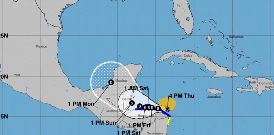
What Are the Forecast Models Saying?
Now, let’s dive into the without getting too deep into meteorological jargon. We’ve got a handful of different models, like the (the American model) and the (the European model), that help predict where Sara might go and how strong it could become. Right now, most of the model guidance suggests that Sara will stick close to the Yucatan and then make its way North before potentially entering the Gulf.
The good news is that many of these models agree that Sara may start to fizzle out over land, with its circulation getting disrupted. The bad news? There’s still a chance it could come out the other side intact and strengthen again over the open waters of the Gulf. This is one of those “wait and see” storms where a lot of variables are still in play.
Meteorologist Brian McNoldy, a Senior Research Associate at the University of Miami’s Rosenstiel School of Marine, Atmospheric, and Earth Science, is known for his in-depth analysis of tropical systems. summed it up well: “Sara’s future largely hinges on its exact track along Central America. A nudge north or south could be the difference between a storm that peters out or one that intensifies again over the Gulf.” This variability makes watching Sara both a bit nerve-wracking and exciting for weather enthusiasts.
Stay Tuned for Updates
At the end of the day, tropical storms like Sara can be unpredictable, and that’s part of what makes tracking them so fascinating. If you’re a weather geek like me, or just someone in the Gulf who wants to stay informed, as the forecast continues to evolve over the next few days. Make sure to bookmark my website for the latest updates. For a list of my services and how I can help after storms pass, check out this link.
Want to know more about how tropical storms like Sara form and what drives their movements? Check out this link.
https://www.hurricanescience.org/science/science/hurricanemovement