High winds are Expected Even If You Don’t Have Severe Weather Warnings, What You Need to know.
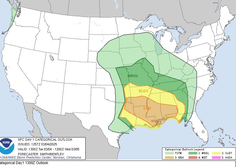
Let me first explain what the different colors mean on the map.
Here is a simple, easy-to-follow breakdown with the severe weather categories clearly ranked from 1 (lowest) to 5 (highest):
Severe Weather Categories (1 lowest – 5 highest):
Category 1: (Light Green – General Thunderstorms)
- Thunderstorms possible but usually not severe.
- Limited risk of severe weather.
Category 2: (Dark Green – Marginal)
- Isolated severe storms are possible.
- Limited risk for damaging wind, small hail, and an isolated tornado.
Category 2: (Yellow – Slight Risk)
- Scattered severe storms possible.
- Potential for damaging winds, hail, and a few tornadoes.
Category 3: (Orange – Enhanced Risk)
- Higher chance for numerous severe storms.
- Increased likelihood of damaging winds, larger hail, and tornadoes.
Category 4: (Red – Moderate Risk) (Not shown on this map)
- Widespread severe weather likely.
- Significant threat of damaging winds, very large hail, and strong tornadoes.
Category 5: (Pink – High Risk)
- Very rare but extremely dangerous weather expected.
- Severe storms are widespread, with significant tornadoes, destructive winds, and large hail likely.
Today’s map specifically highlights areas ranging from general thunderstorm activity (Category 1, Light Green) up to an Enhanced Risk (Category 3, Orange). If you are within the orange area, it’s especially important to stay alert, have a plan, and monitor local weather reports closely throughout the day.
Good Tuesday to you. If you live in the Mid-South and surrounding regions, you’ll want to pay close attention to the weather on Tuesday. A powerful storm system is going to affect millions of people Tuesday and it’s packing quite a punch with damaging winds, heavy rain, and yes, even the possibility of tornadoes, although the greatest threat is South of Memphis, at least at this point. Things can change.
This system won’t stop there—it’ll continue pushing east overnight, affecting parts of the Southeast and Gulf Coast. So if you call those areas home, you’ll need to stay weather-aware too.
Let me explain what to expect and how to keep yourself and your loved ones safe during this weather event.
Timing & What to Expect in the Mid-South
Here’s an easy-to-understand explanation of the forecast discussion you provided, simplified for anyone who isn’t familiar with meteorology:
What Today’s Weather Means for You:
🌦️ What’s Happening Today:
- A large storm system is developing and moving across the region. Think of it as a big spinning storm system currently located west of us, slowly heading our way.
Why is it windy already?
- The storm system is strong, creating differences in air pressure. These differences cause winds to blow harder. Today, winds could gust up to 25 mph this morning and even as strong as 50 mph later, which is why a Wind Advisory is in effect.
Thunderstorms this afternoon:
- A few scattered showers may occur from now through lunchtime, but the main event will be a line of strong thunderstorms moving through this afternoon and evening.
Main Severe Threat:
- The biggest concern with today’s storms is damaging winds. Strong winds could damage trees, power lines, and structures. This is especially true in the areas marked in orange (Enhanced Risk) on the earlier map.
What about tornadoes?
- While the main risk is damaging wind, there’s still a smaller chance (but still possible) for one or two tornadoes. The greatest tornado risk is slightly further south, in the ArkLaMiss region, but it still can’t be completely ruled out for areas of the Mid-South.
When will storms arrive and leave?
- The main line of storms should arrive around:
- Eastern Arkansas around 1-2 PM
- Memphis area between 2 PM and 5 PM
- The storms will mostly leave the region by 8 PM.
Any flooding concerns?
- Brief heavy rains from these thunderstorms might cause minor flooding, especially affecting small streams or poorly drained areas, but major flooding isn’t expected.
After the storms:
- Once the line passes through, the weather will quickly dry out, with only a few isolated, weaker showers remaining. A small chance of showers may linger near the Tennessee/Kentucky border, but it won’t amount to much.
Stay alert, have a plan for safety, and stay updated through the afternoon and evening!
If you ever need a weather expert for insurance disputes, you can contact one here
What About Other Regions?
Gulf Coast & Southeast (Tuesday Night – Early Wednesday)
Your turn comes overnight if you’re in Louisiana, Mississippi, Alabama, or the Florida Panhandle. This region faces a higher tornado risk, particularly with isolated storms ahead of the main line. Gulf Coast residents should be especially vigilant for strong tornadoes and damaging winds.
Here’s a simple, non-technical breakdown of today’s severe weather outlook from the Storm Prediction Center, focusing on regions beyond the Mid-South:
Regions with Severe Weather Concerns (Outside Mid-South)
East Texas, Louisiana, Mississippi, Alabama, and the Southeast:
- Severe thunderstorms will be likely today, especially along a quickly-moving line of storms heading eastward.
- Strong winds are the biggest threat. Winds could cause damage to roofs, trees, power lines, and structures.
- A few isolated tornadoes could occur, with the greatest tornado risk expected in areas closer to Louisiana, Mississippi, and Alabama.
- Some thunderstorms might form ahead of the main line, but these should be fewer and short-lived because the line itself is moving fast.
Timing:
- East Texas and Louisiana storms early to mid-afternoon.
- Mississippi and Alabama storms later this afternoon into tonight.
Be prepared:
- Stay alert, especially if you are in the areas highlighted in orange (Enhanced Risk).
- Have a reliable way to get weather alerts throughout the day.
Eastern Kansas to Western Illinois:
- There’s a smaller chance of severe weather here today, but it’s still important to stay aware.
- As the storm moves east, colder air above may create conditions for some strong thunderstorms.
- These storms could briefly become severe, producing damaging winds, small hail, and possibly even a brief tornado.
- This risk will mostly be during daytime hours and should decrease quickly by evening.
Quick summary for today:
- Stay alert if you’re anywhere from East Texas across the Deep South into Mississippi and Alabama. The strongest storms will likely happen in these areas.
- Further north (Eastern Kansas through Western Illinois), expect isolated strong storms that might produce severe weather, mainly during daylight hours.
Overall, if you live in any of these highlighted areas, pay attention to local weather reports, have a way to receive warnings, and make sure you know what to do if severe weather approaches your area today.
Final Takeaway: Stay Aware, Not Scared
- Mid-South: Prepare for strong winds throughout Tuesday and intense storms by afternoon and evening.
- Southeast & Gulf Coast: With a concerning tornado threat, your weather deteriorates late Tuesday into early Wednesday.
- Missouri & Kansas: Expect some morning and afternoon storms, but the worst conditions will be to your south.
Most importantly—stay updated! Ensure you have multiple ways to receive weather warnings (weather radio, smartphone alerts, local TV). Know where your safe space is in your home and have a plan for everyone in your household, including pets.
Remember, being prepared isn’t about panicking—it’s about having peace of mind knowing you’ve done what you can to stay safe during severe weather.
Also know not everyone will be hit, but you should be prepared.
This is always a good link for additional information.https://www.weather.gov/meg/