
A hurricane could form in the Gulf of Mexico this week, perhaps rapidly, and two important weather models are giving us insights into what we can expect in the coming days. While nobody can predict the exact outcome of a hurricane this far in advance, these models provide a solid picture of what could happen. Both show a potentially dangerous storm heading toward the Gulf Coast. Here is what they show as of this afternoon.
There are dozens of models, but for this blog post and to keep it simple, I am using two: The Artificial Intelligence European Model and the GFS (Global Forecast System)
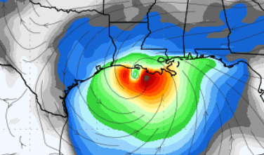
1. The European Model (AIFS) is the first image. This AI-powered model is still in its infancy. It processes tons of data to make highly detailed forecasts about the weather.
2. The Global Forecast System (GFS): This image is directly above. This is a widely used model run by the United States. It also gives us valuable information about where the storm is heading and how strong it might be.
Here is what the colors mean.
In both models, the maps have distinct colors, which tell us a lot about the hurricane’s intensity and potential impact.
Map 1: The European Model (ECMWF)
– Bright Red & Orange: This is the storm’s strongest area, on the East side. In this case, the red and orange colors represent the strongest part of the hurricane. These colors indicate very intense winds.
The European model shows this potential hurricane heading towards the Gulf Coast, making landfall in Louisiana. It suggests that the storm is well-organized and grows stronger as it moves over the Gulf’s warm waters.
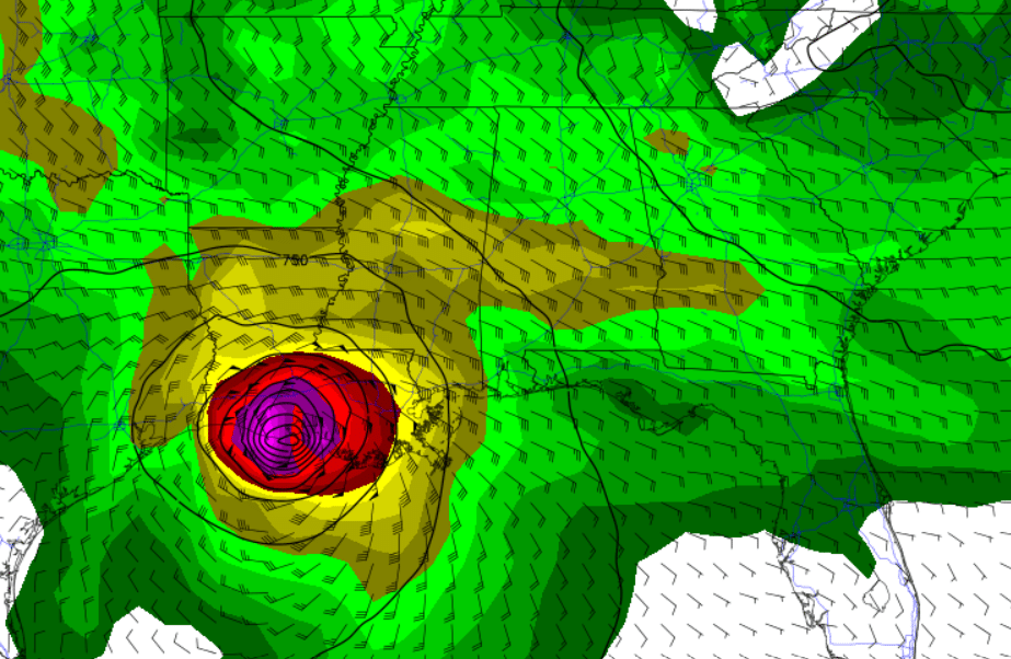
Map 2: The GFS Model
– Purple & Dark Red in the Center: This is the heart of the storm. The deeper the color, the more intense the storm. The purple and red areas have the strongest winds and the lowest pressure. The areas could see the worst wind damage, heavy rainfall, and dangerous storm surge along the coast. Remember that things can and will probably change, but the point is that a tropical system will significantly impact the Gulf next week across a large part of the coast.
– Yellow & Green Around the Center: This shows the extent of the storm’s wind field and rain. The yellow areas show where intense winds extend out from the center, and the green areas indicate heavy rainfall. Even though they are not at the storm’s center, these areas can still experience damaging winds and flooding.
Mid-level winds and rainfall could extend far beyond the storm’s core, suggesting that areas far away from the immediate coast will still get significant rain and wind.
What about timing?
Currently, the consensus between both models suggests Wednesday as the day for landfall. However, it is important to remember that these are models, and the storm has not developed yet. Forecasts often shift as new data becomes available.
While Wednesday seems like the most likely time, the storm could speed up or slow down, which would change when and where it makes landfall. This is why staying updated as we get closer to midweek is essential. You will want to watch for adjustments to the timing as the new model runs come in over the next few days.
What the Models Are Telling Us
Both models agree that a potentially dangerous hurricane is heading toward the Gulf Coast, with landfall around midweek—likely Wednesday. Here are the key takeaways:
1. Strong Winds and Storm Surge: Both models’ bright red and purple areas represent the highest winds, which will be especially dangerous near the storm’s center. Coastal areas must be on high alert for damaging winds and a potentially life-threatening storm surge (where the ocean waters rise along the coast).
2. Heavy Rainfall: Both models show that even areas away from the storm’s eye could see heavy rain and flooding.
3. Wide Area of Impact: Even if you are not directly in the path of the eye, millions of people can expect rain, wind, and power outages. The outer bands of the hurricane, shown in blue and green, extend far beyond the center.
What Should You Do?
Stay Informed: Check updates from local authorities, the National Hurricane Center, and meteorologists. Storm paths can change quickly; the latest updates arrive every few hours.
– Prepare: If you live anywhere along the Gulf Coast or have interests (like property or travel plans), now is the time to prepare. Secure loose objects outside, stock up on supplies, and plan now!
– Do not Panic, but Be Ready: This could be a serious storm, and staying informed and prepared can keep you safe.
While the exact landfall point is still uncertain, anyone in this region should be ready for high winds, heavy rain, and storm surge. Wednesday is the likely time for the storm to make landfall, but timing and track could change as we get closer, so it is essential to stay tuned. I will be watching for you.