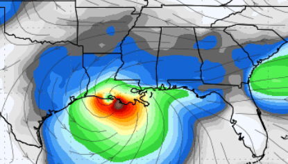
Francine is a tropical storm with winds around 65 mph, but it could get stronger soon. The storm showed signs of strengthening earlier, but some dry air got into the storm, which weakened it slightly. Planes flying into the storm still found it holding steady at 65 mph. However, the pressure has dropped, which usually means the storm could start getting stronger again. Strong winds and rain bands are already near northeastern Mexico and southern Texas.
Francine is moving slowly to the northwest but will pick up speed and turn more to the northeast by Tuesday, influenced by a weather system over Texas. This path will likely take the storm to the Louisiana coast by Wednesday afternoon or evening. While the models that predict the storm’s path agree on this general track, there’s still some uncertainty about when exactly it will reach the coast.
The environment around Francine is primarily favorable for strengthening in the next day or so because the water is very warm, and there isn’t much wind shear (which can disrupt storms). However, just before landfall, the storm is expected to encounter stronger winds aloft, which will likely stop it from getting any stronger. Once it moves inland, it will weaken quickly.
Here are the key points with the late-night update.
- Storm Surge: Areas along the Upper Texas and Louisiana coastlines could experience dangerous storm surges (a rise in seawater level that can flood coastal areas). People in these areas should listen to local authorities and evacuate if told to.
- Strong Winds: Hurricane-force winds (over 74 mph) are expected in parts of southern Louisiana by Wednesday, so people should have their preparations done by Tuesday night.
- Flooding: Heavy rainfall could cause flash flooding along the coast of northeast Mexico, southern Texas, Louisiana, and Mississippi. Later in the week, flash flooding could also affect the Mid-South (areas like northern Mississippi and Tennessee).
Regardless, Francine is expected to get stronger, make landfall in Louisiana, and bring dangerous winds, a storm surge, and flooding to various areas along the Gulf Coast and hundreds of miles inland. People in the storm’s path should rush to complete their plans. I will be watching.