A developing tropical depression over the Caribbean is gaining attention. Here’s what’s happening and important information to know.
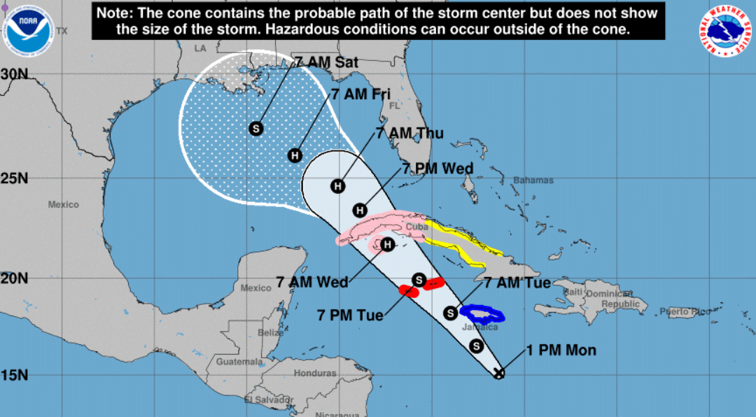
The tropical depression, identified using data from aircraft observations and satellite images, is in the southcentral Caribbean Sea. This system has organized enough to become classified as a tropical depression, which essentially means it has a clear center and bands of thunderstorms spiraling around it. It’s moving at about 9 mph (15 km/h) in a direction slightly north of due west.
The path may change.
Here’s where it gets tricky: The forecast becomes uncertain once the system enters the Gulf. This uncertainty stems from differing opinions among weather models about how the storm might be steered by surrounding weather systems and how strong it could become.
It could intensify. Right now, the environment around the storm is favorable for strengthening. Conditions like warm sea surface temperatures and low wind shear (gentle upper-level winds) help the storm gather energy. As the system moves over western Cuba and into the southeastern Gulf, it is expected to intensify steadily.
However, once it reaches the central Gulf of Mexico, it may face obstacles like stronger upper-level winds (southwesterly vertical wind shear), drier air, and slightly cooler waters. These factors can disrupt a storm’s organization and strength, potentially causing it to weaken before it moves further north.
The official track forecast provided by the National Hurricane Center (NHC) acknowledges some uncertainty, especially once the system enters the Gulf. While we know it’s heading that way, where it might go and how strong it could be when it gets there isn’t set in stone. Residents and those interested in the Gulf region should stay updated frequently.
What to Watch For
Possible Warnings for the Florida Keys: As the storm progresses, tropical storm watches might be issued for parts of the Florida Keys. Keep an ear out for official announcements if you’re in this area.
Heavy Rain and Flooding Concerns: Heavy rainfall is expected alongside the wind, especially as the system approaches. This could lead to localized flooding in vulnerable areas by mid to late week.
Stay Prepared: While it’s still too early to say what exact impacts the Gulf Coast might face, the best step now is to remain informed and be ready to act if forecasts indicate more severe threats.
Bottom Line
The tropical system entering the Gulf of Mexico later this week could bring heavy rain, wind, and a potential storm surge. While it’s too soon to make solid predictions about landfall or strength, keeping an eye on updates is critical. This is a developing situation that could shift, so regular check-ins of my blog are essential this week. Check out The Hurricane Center’s homepage for additional details.