A potential winter storm with still a high degree of uncertainty with many moving parts is set to bring heavy snow, freezing rain, and even perhaps only small amounts of frozen precipitation and most certainly dangerously cold temperatures to the Mid-South beginning Tuesday afternoon and lasting through Saturday morning. Here’s what you need to know:
What’s Happening?
A strong Arctic cold front is moving into the region, and will bring a mix of snow, sleet, and freezing rain. This will create hazardous travel conditions and potentially record-breaking cold temperatures later in the week.
If you ever need an expert meteorologist witness for weather-related litigation, you can click here
Key Highlights:
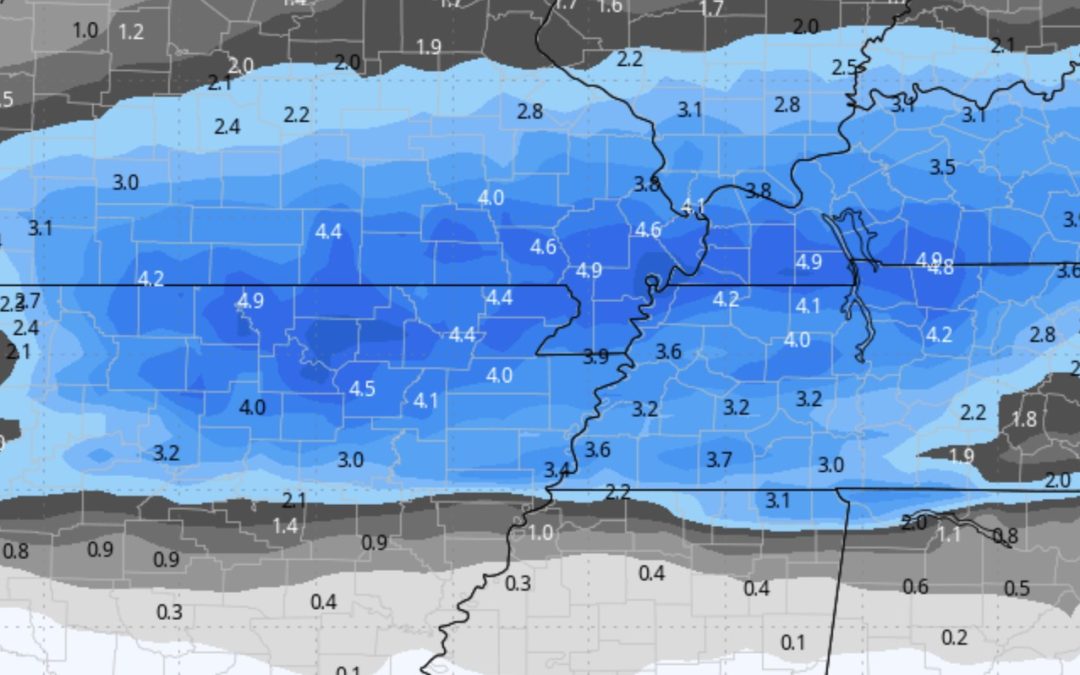
- Winter Storm Warning: Areas along and north of a line from Wynne, AR, to Jackson, TN, to Camden, TN, are expected to see 3 to 5 inches of snow.
- Winter Weather Advisory: South of Interstate 40, including the Memphis metro, a mix of freezing rain, sleet, and light snow will create slippery roads and travel difficulties.
- Uncertain Snow Totals: The exact snowfall amounts remain uncertain due to the mix of precipitation types.
- Bitter Cold Ahead: Once the storm passes, temperatures will remain below freezing for 72+ hours, with wind chills dropping below zero in some areas by Thursday morning.
Timing & Impact
- Tuesday Afternoon – Evening: Precipitation begins, with a wintry mix south of I-40 and snow north of I-40.
- Overnight Tuesday – Wednesday Morning: Snow intensifies, with possible banding leading to locally higher amounts.
- Wednesday Morning – Afternoon: Snow tapers off, but frigid Arctic air moves in.
- Wednesday Night – Friday: Dangerous cold sets in, with below-zero wind chills possible.
Travel & Safety Tips
- Avoid Travel: Roads will quickly become slick and hazardous. If you must drive, take it slow and allow extra time.
- Prepare for Power Outages: Ice accumulation could lead to downed trees and power lines.
- Dress in Layers: Extreme cold can be dangerous. Bundle up if heading outside.
- Check on Vulnerable Populations: Elderly neighbors and those without reliable heat may need assistance.
- Keep Pets Safe: Bring pets inside and provide extra warmth.
Looking Ahead
The good news? Warmer temperatures are expected early next week, with highs reaching the 60s and lows in the 40s. Until then, stay weather-aware and be prepared for hazardous winter conditions.
Stay tuned for my updates, and stay warm.
Thanks John for the weather information.
You are most welcome Gayle!