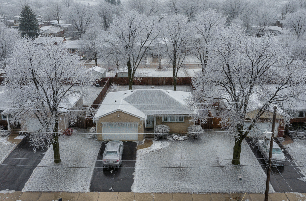
AR-TN-MS Ice Storm Timeline (Jan 23-25): Ice Totals, Power Risk, Road Impacts
Author: John Bryant, AMS/NWA Certified Forensic Meteorologist
| Location | Mid-South (Arkansas, Tennessee, Mississippi) – Ice Storm Warning counties in North MS; Winter Storm Warning AR/TN/MS |
|---|---|
| Time Window | January 24, 2026 6:00 PM CST through January 25, 2026 6:00 PM CST (January 25, 2026 00:00 UTC – January 26, 2026 00:00 UTC) |
| Max Ice (Forecast) | 0.75+ inches (19+ mm) across North Mississippi Ice Storm Warning area; medium-high probability (60-90%) per NWS Memphis AFD issued 2026-01-22 18:54 UTC |
| Max Snow/Sleet (Forecast) | 4-8 inches general; 10+ inches (30-50% probability) northeast Arkansas, Missouri Bootheel, northwest Tennessee per NWS Memphis |
| Data Sources | NWS Memphis Area Forecast Discussion (AFD), Weather Prediction Center (WPC), deterministic model soundings, ASOS/AWOS network |
| Confidence | High for dangerous icing and extreme cold; Medium-High for specific ice/snow/sleet amounts due to narrow precipitation-type boundaries |
Synoptic Setup and Mechanism
A cut-off surface low pressure system near Baja California will be absorbed by a deep upper-level trough on January 23-24, 2026. This absorption enhances southwesterly flow aloft, feeding ample moisture through the atmospheric column. Meanwhile, surface high pressure over southern Illinois establishes a wedge of cold air at the surface across the Mid-South.
The critical factor for ice storm development is the thermal profile. NWS Memphis model soundings show a classic “warm nose” aloft (temperatures above 0°C/32°F) between 850-700 mb, while surface temperatures remain 25-30°F. Precipitation falls as rain from the warm layer, then freezes on contact with subfreezing surfaces.
North Mississippi lies directly beneath the strongest warm nose, resulting in the Ice Storm Warning with crippling ice accumulations forecast. Areas along and south of Interstate 40 between I-55 will see more sleet mixing due to a deeper subfreezing layer, which paradoxically reduces pure ice accumulation but creates hazardous travel nonetheless.
Timeline by Metropolitan Area
Memphis, Tennessee (Shelby County)
Friday Night (January 24): Wintry precipitation begins after 6 PM CST with mixed sleet and freezing rain. Sustained winds 15-20 mph with gusts to 30 mph create wind chill hazard. Bridge decks and overpasses freeze first.
Saturday (January 25): Heavy mixed precipitation continues through afternoon with brief lulls. Accumulations of 0.10-0.25 inch ice plus 2-4 inches sleet. I-40 Mississippi River Bridge and elevated interchanges impassable by midday.
Sunday (January 25): Precipitation tapers by early evening. Temperatures remain below freezing preventing any melt. Arctic air mass arrives overnight with lows near 5°F.
Little Rock, Arkansas (Pulaski County)
Friday Night: Snow begins after 9 PM CST, transitioning to sleet by midnight. Winds gusting 25-30 mph create near-blizzard conditions with blowing snow.
Saturday: Heavy sleet continues with 5-7 inch accumulations expected. Some mixing with freezing rain creates glazing on I-40/I-430 interchange. Thundersleet possible with embedded convection.
Sunday: Precipitation ends by late afternoon. Snowpack and ice prevent warming. Wind chills drop to -5°F to -10°F Sunday night.
Tupelo, Mississippi (Lee County) – Ice Storm Warning
Friday Night: Freezing rain begins 6-8 PM CST. This is the primary threat zone for crippling ice accumulations of 0.75-1.00 inch.
Saturday: Continuous freezing rain with brief breaks. Widespread tree damage and power outages begin by midday. US Highway 78 and Natchez Trace Parkway become impassable. Some sleet mixing reduces pure ice totals slightly but does not mitigate danger.
Sunday: Freezing rain continues into afternoon before ending 6-8 PM CST. Total ice accumulations 0.50-1.00 inch widespread with localized amounts exceeding 1.00 inch possible.
Limitations and Uncertainty Factors
Despite high confidence in a significant ice storm, several factors introduce uncertainty into specific accumulation forecasts:
Precipitation Type Boundaries: The transition zone between freezing rain and sleet will be narrow (10-20 miles wide) and shift position during the event. Areas along I-40 face the highest uncertainty in precipitation type, which directly impacts whether ice or sleet accumulates.
Warm Nose Intensity: Small variations in the strength and elevation of the above-freezing layer aloft (the “warm nose”) can significantly alter ice vs. sleet ratios. Deterministic models show some disagreement, with European models favoring slightly more extensive icing compared to American GFS guidance.
Timing Gaps: NWS Memphis forecasters note potential “lull periods” in precipitation intensity, particularly Saturday evening. These breaks could allow brief warming or cooling that shifts precipitation types.
Mesoscale Banding: Embedded bands of heavier precipitation may create localized areas of higher accumulations. These features typically emerge only 6-12 hours before occurrence and may not be captured in current guidance.
Surface Temperature Sensitivity: Once snow or sleet begins accumulating, the white surface albedo reflects solar radiation and drives surface temperatures even colder. This can change a marginal sleet situation into deeper cold and more sleet, reducing ice accumulations but not reducing danger.
Ice Accumulation Thresholds and Damage Expectations
Ice accumulation severity follows well-documented thresholds based on decades of utility and forestry damage surveys:
Impact Thresholds
0.10-0.25 inch ice: Hazardous driving, especially bridges and overpasses. Small tree limbs break. Minor power outages (<5% of customers).
0.25-0.50 inch ice: Dangerous to impossible travel. Moderate tree damage begins. Power outages affect 5-20% of customers. Restoration 24-72 hours.
0.50-0.75 inch ice: Widespread tree damage. Major limbs and some whole trees fail. Power outages 20-50% of customers. Restoration 3-7 days. Significant infrastructure damage to utility poles and lines.
0.75-1.00+ inch ice (Ice Storm Warning threshold): Crippling damage. Extensive tree failures including large hardwoods. Power outages 50-90% of customers. Restoration 7-14 days or longer. Cascading failures of utility infrastructure. Impassable roads from fallen trees and downed power lines.
North Mississippi faces probabilities of 60-90% for ice accumulations exceeding 0.75 inch according to NWS Memphis probabilistic guidance issued January 22, 2026. This places most of the Ice Storm Warning area in the “crippling” damage category.
For forensic analysis and claims evaluation, note that ice accumulation is typically measured on elevated horizontal surfaces away from building heat sources. Standard ice measurement uses a board or similar flat surface exposed to precipitation. This methodology will be critical for insurance adjusters and expert witnesses evaluating property damage claims.
Travel Impacts: Interstates, Bridges, and Airports
Interstate Corridors at Highest Risk
I-40 Corridor (Memphis to Little Rock; Memphis to Jackson, TN): This interstate lies directly in the mixed precipitation zone Friday night through Sunday. The I-40 Mississippi River Bridge at Memphis will become impassable Saturday with ice and blowing sleet reducing visibility to near-zero at times. Elevated sections through Shelby and Fayette Counties (Tennessee) freeze 3-4 hours before ground-level roads.
I-55 Corridor (Memphis to Grenada, MS): This route traverses the heart of the Ice Storm Warning area in North Mississippi. Expect impossible travel conditions Saturday afternoon through Sunday evening. DeSoto, Marshall, Benton, and Lafayette Counties will see the worst conditions with 0.75+ inch ice accumulations on all surfaces.
I-22 Corridor (Memphis to Tupelo): This newer interstate passes through the most severe icing zone. The stretch from Byhalia, MS to Tupelo will be particularly hazardous with steep grades and curves compounding ice danger.
I-240/I-440 Memphis Loop: All elevated interchanges and overpasses become skating rinks Friday night. The I-240/I-55 interchange, Hernando DeSoto Bridge approaches, and the I-40/I-240 interchange present extreme hazards.
Bridge and Overpass Risk
Bridge decks freeze when air temperatures reach 35-36°F, several degrees warmer than ground-level surfaces. With forecast temperatures 25-30°F Friday night and wind chills in the teens, bridges will freeze immediately upon first precipitation contact.
Critical structures include the I-40 Mississippi River Bridge (Memphis), US-78 Tombigbee River crossings, and hundreds of smaller overpasses throughout the three-state area. For liability cases involving bridge accidents, meteorological evidence must demonstrate not only precipitation occurrence but also the timing when bridge temperatures dropped below freezing relative to the accident time.
Airport Operations
Memphis International Airport (KMEM): Expect significant delays and cancellations beginning Friday evening. De-icing operations will be continuous Saturday. The mix of ice and sleet creates challenges for ground crews. Runway closures likely Saturday afternoon.
Little Rock Airport (KLIT): Heavy sleet accumulations Saturday will shut down operations by midday. Snow removal equipment effective but ice underneath sleet creates ongoing hazards.
Tupelo Regional (KTUP): Freezing rain will force closure Saturday morning. Airport may remain closed 48-72 hours due to power outages affecting runway lighting and navigation aids.
Power Outage Risk and Infrastructure Vulnerability
The combination of heavy ice loading, gusty winds Friday, and weakened trees from previous storms creates high probability for widespread, extended power outages across the Mid-South.
Highest Risk Zones
Critical Risk (50-90% customer outages expected):
- North Mississippi Ice Storm Warning counties: DeSoto, Marshall, Benton, Tippah, Alcorn, Prentiss, Tishomingo, Union, Lee, Pontotoc, Lafayette, Panola, Tate, Yalobusha
- West Tennessee border counties: Shelby (partial), Fayette, Hardeman
Moderate Risk (20-50% customer outages expected):
- Memphis metro (mixed ice and sleet reduces but does not eliminate risk)
- Northeast Arkansas counties in Winter Storm Warning
- West Tennessee north of I-40
Restoration Timeline Factors
Power restoration after ice storms depends on several factors that forensic meteorologists must consider when analyzing utility response for legal cases:
- Ice Accumulation Severity: Areas with 0.75+ inch ice require pole and line replacement, not just repairs. This extends restoration from days to weeks.
- Access Constraints: Fallen trees and impassable roads delay crew access. Typical repair times double or triple when roads are blocked.
- Extended Cold Period: With 72-96 hours of sub-freezing temperatures forecast, ice remains bonded to lines preventing safe work. Crews cannot restore power until temperatures rise above freezing or ice mechanically removed.
- Compounding Damage: As temperatures drop into single digits Sunday-Tuesday, additional ice contraction can cause delayed failures of already-damaged infrastructure.
- Mutual Aid Limitations: The widespread nature of this event means mutual aid crews from neighboring states are likely already deployed or facing their own storm impacts.
For business interruption claims, expect 7-14 day restoration timelines in the Ice Storm Warning area, with some rural locations possibly extending to 21 days. These timelines are consistent with historical ice storms of similar magnitude (Kentucky 2009, Arkansas 2000, Tennessee 1994).
Arctic Blast and Extended Cold Period: Compounding Damage Factor
The ice storm’s impacts will be compounded by an arctic air mass arriving Sunday night that will keep temperatures below freezing for 72-96 hours and drive wind chills to dangerous levels.
Temperature Forecast
Sunday Night (January 25-26): Lows in the single digits (0-9°F) across the entire Mid-South. Wind chills -5°F to -15°F. Rural areas and under clear snowpack could see below zero air temperatures.
Monday-Tuesday (January 26-27): Daytime highs struggle to reach 15-20°F. Nighttime lows again in single digits. Wind chills remain below zero most of the time. This is dangerous cold for the Mid-South where infrastructure is not designed for arctic conditions.
Wednesday-Thursday (January 28-29): Slow moderation begins with highs reaching upper 20s to low 30s, but overnight lows still in teens. Ice and snow remain on roads through this period.
Cold Weather Impacts on Infrastructure and Liability
The extended cold period creates several additional liability concerns beyond the initial ice storm:
Pipe Freezes and Bursts: With 96+ hours below freezing and many hours in single digits, uninsulated pipes in attics, crawl spaces, and exterior walls will freeze. Southern construction standards do not typically include the pipe insulation common in northern states. Expect widespread frozen pipe insurance claims beginning Monday-Tuesday.
HVAC System Failures: Heat pumps lose efficiency below 35°F and become ineffective below 20°F. With prolonged single-digit temperatures, many homes will be without adequate heat even if power is restored. Premises liability cases may arise from inadequate heating in rental properties or commercial buildings.
Ice Dam Formation: Unlike typical ice dams in northern climates (caused by snow melt), this event may see ice dams from the initial freezing rain accumulation on roofs. With no thaw period for 4+ days, this ice remains in place and can lead to roof leaks and interior water damage.
Slip and Fall Hazards: Ice on walkways, parking lots, and stairs will remain dangerous through midweek. Property owners must be aware that typical “24-hour rule” for snow/ice removal does not apply when temperatures never rise above freezing. Melting and treatment are meteorologically impossible during this timeframe.
Carbon Monoxide Incidents: Extended power outages in extreme cold drive improper use of generators, grills, and other combustion devices indoors. Forensic meteorologists may be called to establish that weather conditions created the emergency that led to improper heating methods.
Practical Implications for Legal and Insurance Claims
Insurance Claims Considerations
This ice storm will generate significant insurance claim volume across multiple lines:
Property Damage Claims:
- Tree damage to structures (roofs, siding, vehicles)
- Roof damage from ice loading and falling limbs
- Interior water damage from frozen/burst pipes
- Ice related roof leaks
- Spoiled food and medications from extended outages
Auto Claims:
- Ice-related accidents (single vehicle and multi-vehicle)
- Vehicles damaged by falling trees and power lines
- Comprehensive claims for vehicles stranded/abandoned
Business Interruption Claims:
- Extended power outages preventing operations (7-14 day claims in Ice Storm Warning area)
- Impassable roads preventing employee access or customer traffic
- Perishable inventory losses
- Equipment damage from power surges during restoration
Frequently Asked Questions About the January 2026 Mid-South Ice Storm
Will Memphis get freezing rain or sleet during the January 2026 ice storm?
Memphis will likely see mixed precipitation with both freezing rain and sleet Friday night through Saturday. NWS Memphis soundings show surface temperatures 25-30°F favoring sleet over pure freezing rain, though some icing is still expected.
How much ice causes tree and power line damage?
Tree and power line damage begins at 0.25 inch of ice accumulation. Widespread damage and extended outages typically occur with 0.50 inch or more. North Mississippi faces 0.75+ inch probabilities at 60-90%, creating crippling conditions.
When does the ice storm end in Little Rock, Memphis, and Tupelo?
Wintry precipitation ends Sunday evening (January 25, 2026) across all three metros. Little Rock clears first by late afternoon, Memphis by early evening, and Tupelo by 6-8 PM CST.
What interstates and bridges are most at risk during this ice storm?
I-40, I-55, and I-22 corridors face highest risk Friday night through Sunday morning. Bridge decks and overpasses freeze first, particularly the I-40 Mississippi River Bridge at Memphis and elevated sections through North Mississippi hill country.
Why is this ice storm particularly dangerous for the Mid-South?
The Mid-South faces a triple threat: crippling ice accumulations (0.75″+ in spots), followed by 72-96 hours of sub-freezing temperatures, then an arctic blast with wind chills below zero. This prevents thawing and compounds infrastructure damage.
What data sources confirm the ice storm threat for Arkansas, Tennessee, and Mississippi?
NWS Memphis issued Ice Storm Warning and Winter Storm Warning effective January 24, 2026 at 6 PM CST. Data sources include NWS Memphis forecast soundings, Weather Prediction Center analysis, and ASOS/AWOS station observations across the Mid-South network.
Regional Variations and State-Specific Considerations
While this is a regional event affecting the entire Mid-South, important variations exist by state and sub-region:
Arkansas: Northeast Arkansas and the Delta region will see primarily snow and sleet rather than pure ice. This creates travel hazards but less infrastructure damage compared to ice. The Buffalo River region and Ozark foothills could see 10+ inches of snow with significant drifting due to winds.
Tennessee: West Tennessee lies in the transition zone with mixed precipitation types creating uncertainty. Memphis metro will see less pure ice than areas 30-50 miles to the south, but the combination of sleet and some ice still creates dangerous conditions. The Tennessee Valley in northern portions of the state may see primarily snow.
Mississippi: North Mississippi is ground zero for this ice storm with the most severe impacts. The hill country topography exacerbates tree damage as ice-laden limbs break under their own weight on slopes. The I-55 corridor from Hernando to Grenada will be impassable for days.
Missouri Bootheel: This region will see heavy snow (8-12 inches possible) with less ice concern. However, the subsequent arctic cold creates prolonged hazards as snow remains on roads through Wednesday.
Summary and Call to Action
The January 23-25, 2026 ice storm represents a significant meteorological event with wide-ranging legal and insurance implications across Arkansas, Tennessee, and Mississippi. Key takeaways include:
- Crippling ice accumulations (0.75″+ with 60-90% probability) across North Mississippi Ice Storm Warning area
- Heavy snow and sleet (4-8 inches, locally 10″+) across broader Winter Storm Warning area
- Dangerous to impossible travel Friday night through Sunday on all interstates and bridges
- Extended power outages expected (7-14 days in worst areas) due to ice loading on trees and power lines
- Arctic blast following with 72-96 hours below freezing, preventing thaw and compounding damage
- High confidence in dangerous conditions; medium-high confidence in specific precipitation type boundaries
For attorneys, insurance professionals, and risk managers: Cases arising from this event will require detailed forensic meteorological analysis to establish causation, timeline, and foreseeability. NCEI archived data combined with NWS official products will provide the evidence base for expert testimony.
Need Forensic Meteorology Analysis for Legal Cases Arising from This Storm?
Weather and Climate Expert Consulting LLC provides court-admissible forensic meteorological analysis using NOAA/NCEI data and NWS archives. Our analysis establishes precise timing, precipitation type, accumulation rates, and causation for insurance claims, premises liability cases, and business interruption disputes.
Services for this event include:
- Hour-by-hour weather reconstruction using ASOS/AWOS observations
- Ice accumulation analysis and verification
- Precipitation type determination (freezing rain vs. sleet vs. snow)
- Foreseeability analysis based on warning issuance timeline
- Expert witness testimony in Arkansas, Tennessee, Mississippi, and federal courts
Contact us for a free case review: 901.283.3099 or [email protected]
Technical Appendix: Methods and Data Quality
Forecast Methodology
This analysis synthesizes output from multiple deterministic numerical weather prediction models and ensemble guidance systems:
Model Guidance: GFS (Global Forecast System), ECMWF (European model), NAM (North American Mesoscale), HRRR (High-Resolution Rapid Refresh), RAP (Rapid Refresh). Model soundings analyzed at 6-hour intervals from January 23, 2026 00Z through January 26, 2026 12Z.
Ensemble Systems: GEFS (Global Ensemble Forecast System) and ECMWF EPS provide probabilistic guidance on precipitation type and accumulation ranges. The 60-90% probability for 0.75″+ ice comes from GEFS plume analysis showing strong agreement across ensemble members.
Mesoscale Analysis: Real-time surface observations from 40+ ASOS/AWOS stations across AR/TN/MS provide ground truth for model verification. Radar data from NWS radars KNQA (Memphis), KLZK (Little Rock), KGWX (Columbus, MS), and KDGX (Jackson, MS) will document precipitation onset, type, and intensity.
Precipitation Type Algorithms
Precipitation type forecasting relies on vertical temperature profile analysis using model soundings. The key thresholds:
- Freezing Rain: Requires a “warm nose” (layer above 0°C/32°F) aloft with surface temperatures below freezing. Rain falls from warm layer, freezes on contact with cold surface.
- Sleet: Requires warm nose aloft but deeper subfreezing layer near surface. Rain freezes into ice pellets before reaching ground.
- Snow: Requires entire atmospheric column below freezing from cloud level to surface.
For this event, model soundings show the warm nose strongest over North Mississippi (favoring freezing rain), weakening northward into Tennessee and Arkansas (favoring more sleet mixing). The transition zone is narrow (10-20 miles) and position-sensitive to small model errors.
Ice Accumulation Calculations
Ice accumulation forecasts use liquid equivalent precipitation (LEP) divided by precipitation duration and adjusted for accretion efficiency. Typical accretion efficiency for pure freezing rain is 0.75-0.85 (75-85% of liquid equivalent becomes ice accretion).
For this event, NWS probabilistic ice accumulation guidance shows:
- 0.25″+ ice: 80-100% probability across Ice Storm Warning area
- 0.50″+ ice: 70-90% probability across Ice Storm Warning area
- 0.75″+ ice: 60-90% probability across Ice Storm Warning area
- 1.00″+ ice: 30-50% probability in worst-case locations (DeSoto, Marshall, Lafayette Counties, MS)
Data Quality and Limitations
ASOS/AWOS Network: Automated surface observing systems provide high-quality temperature, wind, and present weather observations every minute. However, ice accumulation is not directly measured by ASOS. Post-event ice measurements require manual observation (typically by NWS cooperative observers) or photographic documentation.
Radar Limitations: Weather radar detects precipitation aloft but cannot directly determine precipitation type at the surface. Dual-polarization radar provides clues (correlation coefficient, differential reflectivity) but soundings and surface observations are definitive.
Model Uncertainty: The narrow transition zone between freezing rain and sleet means small forecast errors (20-30 miles) can significantly change the precipitation type at a given location. This is inherent uncertainty in winter weather forecasting and does not reflect forecaster error.
Observation Gaps: Rural areas have fewer observation points. Ice accumulation may vary significantly over short distances due to elevation changes, urban heat island effects, and microclimatic factors.
Post-Event Verification
After the event concludes, NCEI Storm Data reports will document observed ice accumulations, power outages, and other impacts. NWS offices conduct post-storm surveys in high-impact areas. These reports become the ground truth for forensic reconstruction.
For legal cases, forensic meteorologists retrieve archived ASOS/AWOS observations (available indefinitely through NCEI) to establish minute-by-minute conditions at the nearest representative station to the incident location. Level II radar data archives provide additional precipitation documentation.
Top 3 Verified Facts from Official Sources
1. Ice Storm Warning Issuance: NWS Memphis issued Ice Storm Warning for 14 counties in North Mississippi effective January 24, 2026 at 6:00 PM CST (00:00 UTC January 25) through January 25, 2026 at 6:00 PM CST (00:00 UTC January 26). Source: NWS Memphis AFD issued 2026-01-22 18:54Z, warning products via weather.gov.
2. Ice Accumulation Probabilities: Medium to high probabilities (60-90%) for ice accumulations exceeding 0.75 inch across North Mississippi Ice Storm Warning area. Source: NWS Memphis AFD statement “probabilities still remain medium to high (60-90%) for ice accumulations exceeding three quarters of an inch,” issued 2026-01-22 18:54Z.
3. Extended Sub-Freezing Period: Temperatures forecast to remain below freezing for 72-96 hours beginning Saturday afternoon January 25, 2026, with air temperatures in single digits Monday-Tuesday and wind chills below zero. Source: NWS Memphis AFD issued 2026-01-22 18:54Z, specific statement “expect the Mid-South residing below freezing for at least 72 hours, with potential to be sub-freezing for 96 hours.”
Need Expert Weather Analysis for Your Case?
Use the contact form below or email me for a free case review.
Forensic Meteorology Resources
Weather Data & Research:
- National Oceanic and Atmospheric Administration (NOAA)
- National Weather Service
- National Centers for Environmental Information
Professional Organizations:
- American Meteorological Society
- AMS Professional Development
- National Weather Association
- SEAK Experts – Forensic Meteorology
Academic Programs:
The author of this article is not an attorney. This content is meant as a resource for understanding forensic meteorology. For legal matters, contact a qualified attorney.