Win Flood Claims with Verified Flood Evidence
Flood-related insurance claims often depend on whether actual conditions meet policy thresholds for coverage. I reconstruct flood events using verified rainfall data, stream gauges, and site-specific hydrology to determine what happened, when it happened, and how severe it was at the exact location.
About This Service
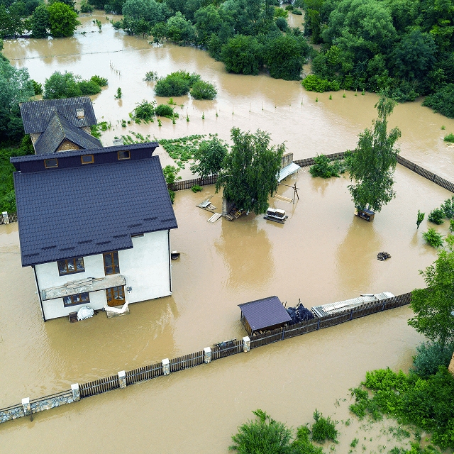
Flood Evidence That Resolves Insurance Disputes
Flooding claims are rarely about general weather conditions. They are about precise, location-specific evidence of water intrusion and intensity.
I analyze rainfall totals, flood models, drainage behavior, and verified station data to establish whether conditions match the claimed loss. This helps clarify coverage eligibility, timing of flooding, and whether reported damage aligns with actual flood conditions.
")
Why It Matters
Flood Coverage Depends on Verified Conditions
Insurance decisions often hinge on specific thresholds such as rainfall intensity, flood depth, and timing of inundation.
When only regional data is used, critical site-level differences are missed. Small variations in terrain, drainage, or storm path can change whether a claim is valid or excluded. Accurate reconstruction removes uncertainty and supports fair claim evaluation.
Core Service Areas
Flood event reconstruction for insurance validation
Analysis of rainfall, streamflow, and hydrology data to confirm whether flood conditions meet policy criteria.
Causation analysis for flood damage claims
Evaluation of whether flood conditions directly caused or contributed to reported property damage.

Policy threshold and exclusion review
Assessment of flood definitions, exclusions, and coverage triggers within insurance policies.

Site-specific flood intensity modeling
Reconstruction of localized flood behavior using verified environmental and hydrology datasets.

Case Types
- Flood insurance disputes
- Water intrusion claims
- Flash flooding property damage cases
- Drainage overflow disagreements
- River overflow loss claims
- Sewer backup flood disputes
- Coastal flooding validation cases
- Stormwater system failure claims
How It Works
1
Submit your request
Provide the location, timeframe, and context of your case, project, or operational need. No technical formatting is required.
2
Define scope & analyze data
I review the details and identify the appropriate datasets, methods, and analytical approach needed for your specific situation. Weather and environmental data are then processed, analyzed, or reconstructed based on the service type.
3
Deliver structured results
You receive a clear, defensible report or insight summary designed for legal, technical, operational, or planning use depending on your needs.
Why Work With John
-

Scientific precision with real-world application
All analysis is grounded in validated meteorological and environmental data to ensure accuracy and reliability across technical, legal, and operational contexts.
-
Clear and defensible insights
Complex weather and environmental data is translated into structured, easy-to-understand findings suitable for professional review and decision-making.
-
Certified expertise and credibility
Work is conducted under rigorous scientific standards, including Daubert-aligned methodology for forensic work and established meteorological best practices.
-
Independent and objective analysis
All conclusions are based strictly on data and established scientific methods, with no assumptions or external bias.


Lamont Matthews
Personal Injury/Weather-Related Vehicular Accident Case
After a harrowing experience of being involved in a motor vehicle accident during a severe winter storm last year, I found myself in an unexpected and challenging situation. The storm brought not just snow but also lots of ice and freezing rain. After the accident, as I stepped out of my car, I slipped on the ice, adding to the complexity of my case. I was initially at a standstill with my insurance company. They disputed the claims about the weather conditions, specifically at the time of the accident. This is when I turned to the expertise of John Bryant. His analysis and reconstruction of the precise weather conditions at the time and location of my accident were remarkable. John’s report detailed the specific weather conditions, including the exact type of precipitation, temperature, and ice conditions at the time and my location. This level of detail was crucial. It was his expert testimony and report that made all the difference. Thanks to his analysis, I was able to settle the dispute with my insurance company quickly after they received his report. I am deeply grateful for John Bryant’s professionalism and expertise. His work not only provided clarity and evidence in my case but also showcased his commitment to applying expert weather knowledge to help people in need when facing challenges like mine. This experience left me with such a respect for forensic meteorology and its significant role in our lives, especially in critical times of need.
New York Attorney
Slip-and-Fall Case
I recently worked with John Bryant of Weather and Climate Consulting, LLC, on a New York slip-and-fall matter in which the ‘Storm in Progress’ defense was the central issue. John’s analysis of NEXRAD radar and site-specific temperature trends was surgical. He pinpointed the exact minute precipitation ceased and tracked the freeze/thaw cycle with a level of precision I haven’t seen from larger national firms. His work provided the objective evidence we needed to establish the timing of the hazard. He is easy to work with, highly responsive, and very cost-effective. If you have a case where the “when” and “how” of ice formation are in question, he is your guy.
Satisfied Defense Attorney
Slip and Fall Case
I hired John Bryant as an expert witness for a slip and fall case involving intricate winter weather data. His exhaustive analysis to find scarce, precise data were instrumental in dismantling the opposition’s claims. The evidence he provided to reconstruct the weather event was critical to securing a favorable settlement for my client. If you need an expert weather witness whose detailed, authoritative reports can distinguish between winning and losing, John Bryant is the person to call.
Satisfied Personal Injury Attorney
Flash Flood Case
John’s Forensic Meteorology expertise was invaluable to a Flash Flood case. When a tragic flash flooding incident occurred in an isolated area, the closest weather reports did not reflect the true conditions at the site. There was not a certified storm report to be found. This posed a serious challenge. However, through his meticulous analysis and reconstruction of the weather patterns, John was able to demonstrate precisely what conditions were like when an individual encountered flood waters that unfortunately led to a loss of life. Despite what the broad regional data showed, he proved beyond a doubt that intense rainfall did occur in that location on that day and weather conditions played a part. John has an uncanny ability to dissect complex weather events and present the findings in a clear, easy to understand manner. His customized report helped bring a bit of justice to such a tragic incident. I would highly recommend retaining John for any legal matter involving the reconstruction of past weather or climate conditions. His skills and precision give attorneys and insurance companies the meteorological facts they need to effectively argue critical cases.
FAQs
- How is flood evidence used in insurance claims?
Flood evidence helps verify whether water levels, rainfall, and timing match the conditions required for coverage approval or dispute resolution.
- Can flood data show if damage was caused by flooding?
Yes. Verified hydrology data can confirm whether flood conditions were severe enough to plausibly cause reported damage.
- Why is site-specific flood analysis important?
Because flood conditions can vary significantly even within short distances, making location-specific analysis critical for accuracy.