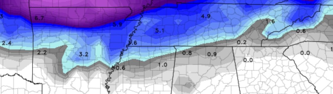
A powerful winter storm is set to bring heavy snow in places, freezing rain, and dangerously cold temperatures to the Mid-South beginning Tuesday afternoon and lasting through Wednesday morning. I want to stress that wind chills will be brutally cold tomorrow morning and afternoon, with a few areas reaching below zero for the wind chill, which can cause frost-bite in minutes. Here’s what you need to know with my latest update. The blue colors in this image indicate 1-3″ inches of snow, with 4 inches not out of the question in a few spots in Memphis and Shelby County. I will be honest: amounts with this system are incredibly tricky to pinpoint.
What’s Happening?
A quick-moving low-pressure system will bring wintry precipitation, dangerously cold temperatures, and hazardous travel conditions across the region.
If you ever need an expert meteorologist witness for weather-related litigation, you can click here
Key Highlights:
- Winter Storm Warning: Areas along and north of Interstate 40 can expect 1 to 6 inches of snow, with the highest amounts near the Arkansas/Missouri and Kentucky/Tennessee borders.
- Winter Weather Advisory: Areas south of Interstate 40 will see 1 to 2 inches of snow and a light glaze of ice, making roads slippery.
- Bitter Cold Ahead: Arctic air will settle in after the storm, keeping temperatures below freezing through late week, with wind chills potentially near or below zero.
Timing & Impact
- This Late Afternoon – Evening: Snow and wintry mix begin in northeast Arkansas and spread across the region.
- Overnight Tuesday – Wednesday Morning: Snow intensifies, especially north of I-40, creating hazardous road conditions.
- Wednesday Morning – Afternoon: Snow tapers off, but blowing snow and Arctic air takes over.
- Wednesday Night – Friday: Extreme cold persists, with wind chills near or below zero in northern areas.
Travel & Safety Tips
- Avoid Travel: Roads will become dangerous, especially where snowbanding occurs. If travel is necessary, drive with caution.
- Prepare for Power Outages: Ice accumulation could cause tree limbs and power lines to fall.
- Bundle Up: Extreme cold can be dangerous. Wear layers, hats, and gloves when heading outside.
- Check on Neighbors & Pets: Vulnerable individuals and pets will need extra care in the cold.
- Stock Up on Essentials: Have flashlights, non-perishable food, water, and emergency supplies ready.
Looking Ahead
This Arctic blast will last through the weekend, with temperatures well below normal. However, the good news is that a warming trend is expected early next week, with highs in the 50s and 60s.
This storm has many moving parts, so remain weather-aware in the coming days.