 All Posts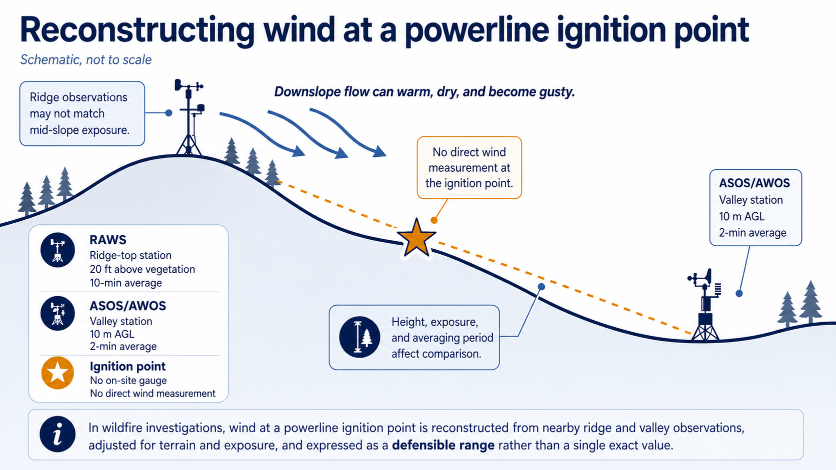


By John Bryant, AMS-, NWA-, and EPA Method 9-Certified Forensic Meteorologist
Last reviewed: . Methodology current as of July 2026.
When a wildfire is traced to electrical equipment, the weather at the moment of ignition often shapes the evidentiary record. A downed conductor, a vegetation contact, or an equipment failure may supply the spark, but wind, humidity, and fuel dryness determine whether that spark dies in the grass or grows into a catastrophic fire. In powerline wildfire litigation, a forensic meteorologist reconstructs those conditions, and whether they were forecast in advance, giving attorneys and insurers a defensible weather record that these matters so often turn on.
John Bryant is an AMS-, NWA-, and EPA Method 9-certified forensic meteorologist and expert witness based in Memphis, Tennessee, specializing in weather reconstruction for slip-and-fall, wind, hail, wildfire, and ice-storm litigation. In utility wildfire matters, that work centers on reconstructing wind, relative humidity, and fuel-dryness conditions at the ignition point and comparing them against what the National Weather Service and Storm Prediction Center forecast in the hours and days beforehand. For the underlying process, see how weather conditions are reconstructed.
This article is general information for attorneys and claims professionals, not legal advice, and it does not resolve any specific matter. A forensic meteorological analysis is based on the weather records available for the exact date, time, and location at issue, and it addresses what those records show and do not show, not the ultimate question of negligence or liability.
Fire-Weather Factors in a Utility Wildfire Reconstruction
The table below summarizes the weather factors a forensic meteorologist reconstructs in a powerline wildfire matter, what each factor drives, where the data comes from, and the key limitation counsel should understand.
| Factor | What it drives | Primary data sources | Key limitation |
|---|---|---|---|
| Sustained wind and gusts | Rate of spread, conductor movement, ember transport | RAWS, ASOS/AWOS, HRRR (transitioning to RRFS) | Nearest station rarely sits at the ignition point; gusts vary sharply with terrain |
| Wind direction | Direction of travel toward or away from structures | RAWS, ASOS/AWOS, reanalysis | Local terrain channels wind; a distant station may not represent the slope |
| Relative humidity | Fuel receptivity and ignition potential | RAWS, ASOS/AWOS | Humidity changes quickly overnight and with elevation |
| Temperature | Fuel drying and downslope warming | RAWS, ASOS/AWOS | Site temperature can differ from valley stations |
| Fuel moisture and drought | Whether fine and heavy fuels will carry fire | NFDRS indices, RAWS, drought monitoring | Fuel moisture is modeled or estimated, not measured at every point |
| Forecast status (Red Flag / Watch) | Foreseeability of dangerous fire weather | NWS Red Flag archive, SPC Fire Weather Outlooks | A warning covers a zone, not a single parcel |
Direct Answer: Does the weather determine utility wildfire liability?
No. Weather evidence does not determine liability in a utility wildfire matter, and a forensic meteorologist should not offer that opinion. What the weather record can establish is narrower and more defensible: the wind, humidity, temperature, and fuel-dryness conditions at the time and place of ignition, how those conditions drove the fire’s initial spread, and what forecasters predicted in the hours and days before the fire started.
The weather record does not prove that a utility acted reasonably or unreasonably, that a de-energization decision was right or wrong, or that equipment failure caused the ignition. Those are legal, operational, and engineering questions. A meteorologist supplies the forecast-and-observed facts; counsel argues duty, breach, and causation from that record and from the other evidence in the matter.
How does weather turn a powerline fault into a catastrophic wildfire?
A powerline fault supplies ignition; the atmosphere supplies the fire behavior. The same spark that dies harmlessly on a calm, humid day can become a fast-moving fire when three conditions align: strong and gusty wind, low relative humidity, and dry fuels. Wind transports embers and pushes the flame front, low humidity makes fine fuels receptive, and drought-dried vegetation carries fire quickly once it starts.
Many of the most damaging utility fires occur during downslope, offshore wind regimes. Santa Ana winds in Southern California, Diablo winds in Northern California, and foehn-type downslope winds elsewhere are warm, dry, and gusty because air descending terrain compresses and warms, which lowers relative humidity. These events often peak overnight and in the early morning, when firefighting resources and detection are most limited.
Damaging utility fires are not limited to the West Coast, however. Dry, gusty winds behind cold fronts across the Southern Plains and Southeast, and downslope Chinook or foehn winds along the Colorado Front Range, can produce comparable fire-weather conditions in matters far from California. The reconstruction method is the same regardless of region; only the wind regime and the local station network change.
What weather conditions matter most in a utility wildfire matter?
Four measurements do most of the work: peak and sustained wind speed with direction, relative humidity, temperature, and indicators of fuel dryness. Each maps to a question counsel will ask, and each is reconstructed from the observational and model record for the specific location.
- Wind speed and gusts: govern rate of spread and ember transport, and may bear on whether conductors moved or contacted vegetation.
- Wind direction: establishes the likely direction of travel toward or away from structures and the reported origin.
- Relative humidity and temperature: indicate how receptive fine fuels were and how effectively fuels had dried.
- Fuel dryness and antecedent drought: indicate whether both fine and heavier fuels were positioned to carry fire.
These same measurements let a meteorologist compare observed conditions against a utility’s own stated wind or operating thresholds, which can be relevant to foreseeability. The comparison is a factual one; whether the utility’s response met a standard of care is a legal question for counsel.
Red Flag Warnings and PSPS: what was forecast, and when?
Foreseeability in a utility wildfire matter often turns on the forecast record. A forensic meteorologist documents whether the National Weather Service had issued a Red Flag Warning or Fire Weather Watch for the area, what the Storm Prediction Center’s Fire Weather Outlooks showed in the days prior, and how observed conditions compared to those forecasts. Because Red Flag criteria are set by local NWS offices and vary by region, a defensible analysis identifies the specific criteria in effect for that zone rather than applying a single national threshold.
Where PSPS decisions fit
Public Safety Power Shutoff (PSPS) programs de-energize lines when fire-weather risk is high. The meteorologist’s role is to establish what conditions were forecast and what conditions were observed. Whether de-energization was warranted, and whether a utility followed its own protocols, is an operational and legal judgment that counsel argues from that weather record. Keeping that line clean, meaning supplying the forecast-and-observed facts rather than the liability conclusion, is what makes the testimony defensible.
What data reconstructs conditions at the exact time and place of ignition?
No single station usually sits at the ignition point, so a defensible reconstruction combines several independent sources and discloses the uncertainty in any interpolated value. The records most often reviewed are:
- RAWS (Remote Automated Weather Stations), the interagency fire-weather network, which report wind as a 10-minute average at the 20-foot (6.1 meter) height above vegetation used in fire-weather analysis.
- ASOS/AWOS surface observations, which report wind as a 2-minute average at the standard 10-meter height, so comparing them to RAWS requires reconciling both the different height and the different averaging period.
- NEXRAD Level II radar, useful for precipitation, outflow boundaries, and in some events smoke or debris signatures.
- SPC Fire Weather Outlooks and the NWS Red Flag Warning and Fire Weather Watch archives, which document what was forecast.
- High-resolution model output such as the HRRR (3-kilometer grid), which is transitioning to the Rapid Refresh Forecast System (RRFS) in 2026, along with reanalysis, used to fill gaps between stations. Archived HRRR output remains available for past dates.
- Satellite thermal detection, led by VIIRS (375-meter resolution) with GOES-East for rapid updates, which can help corroborate fire timing and early progression. MODIS provides a historical archive for older events as its instruments approach end of service.
Station spacing rarely matches the ignition point exactly, which is why interpolation and modeling are part of the reconstruction rather than an afterthought. The strength of the analysis depends on stating that uncertainty plainly, not concealing it.
How the Weather Records Fit Together
In practice, these records are layered from the most direct observation to the modeled estimates that bridge the gaps between them:
- 1Nearby fire-weather observations: RAWS closest to the ignition point, at the 20-foot fire-weather wind standard.
- 2Airport surface observations: ASOS/AWOS at the 10-meter standard, reconciled for height and exposure.
- 3High-resolution model and reanalysis fields: HRRR (transitioning to the RRFS in 2026) and reanalysis used to estimate conditions between stations.
- 4Forecast products: Red Flag Warnings, Fire Weather Watches, and SPC Fire Weather Outlooks for the foreseeability question.
- 5Satellite and radar corroboration: VIIRS (375 meter) and GOES-East, with NEXRAD, to support timing and early progression (MODIS as historical archive only).
How does wind-gust reconstruction at the ignition point work?
When no wind gauge sat at the ignition point, a meteorologist estimates conditions there by combining the nearest station observations with terrain and high-resolution model wind fields. The goal is a defensible range for the likely wind at that location and time, not a single false-precision number. Gusts matter as much as sustained wind because brief peaks are what move conductors, which can cause conductor-to-conductor or conductor-to-vegetation contact, and what loft embers ahead of the fire.
Reconciling instruments is part of the work. RAWS report a 10-minute average at the 20-foot height above vegetation, while ASOS and AWOS report a 2-minute average at 10 meters, so the two cannot be compared without accounting for both the height and the averaging period. Where fire behavior is at issue, a Wind Adjustment Factor may also be applied to translate an open-station wind to the midflame wind that actually drives spread. Where a utility has published wind or operating thresholds, the reconstructed range can be compared against them as a factual matter, leaving the reasonableness of any operating decision to counsel.
What can, and cannot, a forensic meteorologist testify to here?
A forensic meteorologist can reconstruct observed and forecast weather, characterize fire-weather severity, establish the timing and spatial pattern of conditions, and assess whether witness or utility accounts are consistent with the weather record. That scope is both useful to counsel and defensible under scrutiny.
A meteorologist should not opine on the ultimate legal issue of negligence or liability, should not offer electrical-engineering causation opinions outside meteorological scope, and does not determine the physical cause and origin of the fire, which is a separate discipline. Staying within that lane is what keeps the testimony credible when it is tested. Under Federal Rule of Evidence 702 and the Daubert framework, an opinion is most defensible when it rests on reliable data and accepted methods and stays within the expert’s field.
Common Attorney Mistakes With Utility Wildfire Weather Evidence
A few recurring assumptions can weaken a weather argument before it reaches an expert:
- Relying on a single distant airport observation to describe wind at a remote ridgeline ignition point.
- Treating a Red Flag Warning as proof that extreme conditions occurred at a specific parcel, when the warning covers a zone.
- Confusing forecast conditions with observed conditions, or the reverse.
- Assuming a gust value from one station applies across complex terrain without adjustment.
- Overlooking the difference between the 20-foot fire-weather wind standard and the 10-meter airport standard.
- Expecting a meteorologist to opine on liability or on the physical cause and origin of the fire.
Hypothetical Illustration
The following is a hypothetical illustration, not a real matter. A fire is reported near a rural distribution line at 2:10 a.m. The nearest ASOS is 14 miles away in a valley, and the nearest RAWS sits on a ridge 6 miles away at a different elevation. Neither station sits at the ignition point.
A defensible reconstruction would combine both stations with high-resolution model wind fields and terrain to estimate the likely wind range at the ignition point, disclose the uncertainty in that estimate, and note whether a Red Flag Warning was in effect for the zone. It would stop short of declaring an exact gust value at the pole or opining on whether the line should have been de-energized. Those limits are what make the resulting opinion usable in litigation.
When to Retain a Forensic Meteorologist
Attorneys and insurers should consider retaining a wildfire meteorology expert witness when a matter is traced or alleged to be traced to electrical equipment and the weather at ignition is in dispute.
Expert review may be useful when the matter involves:
- A utility or powerline ignition where wind, humidity, or fuel dryness is contested.
- A dispute over whether dangerous fire weather was forecast, including PSPS and de-energization decisions.
- Disagreement about wind speed or direction at a remote ignition point.
- A rural ignition point with no nearby weather station.
- Subrogation or insurance recovery where the fire-weather record affects causation or foreseeability.
Frequently Asked Questions About Powerline Wildfire Weather Analysis
Do you need the utility’s records to reconstruct the weather?
No. Weather reconstruction can proceed independently from public and archived meteorological data. Utility operating data, such as recorded line conditions or internal wind thresholds, can strengthen and contextualize the picture, but it is not required to establish the weather record.
Can weather be reconstructed for a rural ignition point with no nearby station?
Yes, using modeled and interpolated data from the surrounding network combined with terrain analysis, with the uncertainty of the estimate clearly stated. The absence of an on-site gauge is a limitation to disclose, not a bar to analysis.
Is this the same as a fire cause-and-origin investigation?
No. Cause-and-origin determination, meaning the physical point and mechanism of ignition, is a separate discipline governed by NFPA 921 and handled by fire investigators. A forensic meteorologist addresses the weather conditions and forecasts, not the physical origin determination.
What is the difference between a Red Flag Warning and what actually happened at the site?
A Red Flag Warning is a forecast product covering a fire-weather zone; it signals that dangerous conditions are expected, not that a specific parcel experienced them. Confirming conditions at the ignition point requires observed and reconstructed data for that location.
Methods and Sources
A forensic meteorological reconstruction in a powerline wildfire matter draws on the following data and authority sources. Specific data must be pulled for the exact date, time, and location at issue:
- NWS Fire Weather program, for Red Flag Warnings and Fire Weather Watches: weather.gov/fire
- NOAA/NWS Storm Prediction Center Fire Weather Outlooks: spc.noaa.gov/products/fire_wx
- RAWS fire-weather observations (Western Regional Climate Center and NIFC): raws.dri.edu and nifc.gov
- NOAA NCEI, for archived surface observations, radar, and climate data: ncei.noaa.gov
- NEXRAD Level II radar archive (NCEI): ncei.noaa.gov radar
- NOAA HRRR high-resolution model output: rapidrefresh.noaa.gov/hrrr
- American Meteorological Society, for professional-standard framing: ametsoc.org
Internal Resources for Attorneys
The following Weather and Climate Consulting LLC resources may help attorneys and claims professionals evaluate weather evidence in wildfire matters:
Conclusion
In a powerline wildfire matter, the weather record frequently sits at the center of the dispute: it establishes how a fault became a fire and what forecasters warned beforehand. A defensible reconstruction reconciles multiple data sources, discloses the uncertainty in any interpolated value, and keeps a clear line between meteorological findings and legal conclusions.
A forensic meteorologist can help attorneys and insurers determine what the weather evidence supports, what it does not support, and what limitations should be disclosed. The strongest opinions rest on multiple reliable data sources, transparent methodology, and a careful distinction between fire-weather facts and questions of liability.
This article is informational and is not legal advice.
Handling a Utility or Powerline Wildfire Matter?
Weather and Climate Consulting LLC reconstructs the wind, fire-weather, and forecast record that these matters turn on: defensible, source-based, and communicated clearly for attorneys, insurers, and the court.
Contact Weather and Climate Consulting LLC to discuss the weather evidence in your matter.